Donald · Borders
Drumelzier Law
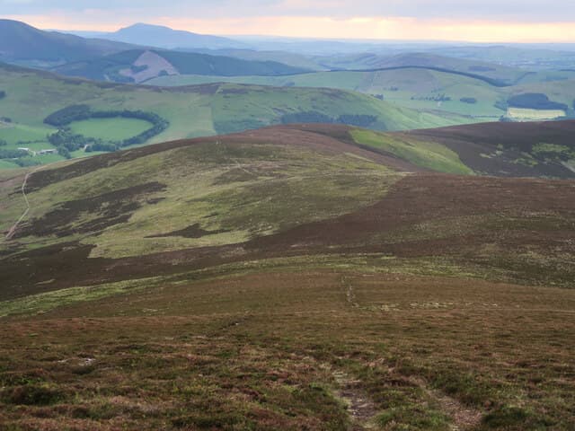
Drumelzier Law overlooks the Tweed valley below Broughton, the western end of the long Manor Hills ridge. A bare patch of trampled grass marks the unmarked top, with the wedge of Tinto rising across Tweeddale to the west.
Quick facts
- Height
- 668m/ 2192ft
- Prominence
- 97 m
- Distance
- 13 km
- Ascent
- 548 m
- Time
- 3–6 hrs
- Grid ref
- NT149312
- Parking
- NT155307
- Nearest city
- Edinburgh· 44km
- Dogs
- Dogs on lead required near livestockDog-friendly guide ↗
Height and prominence cross-checked against the Database of British and Irish Hills (CC BY).
No GPX track yet
Walked this route? Share your track to help other walkers.
Standard route
grass moorland 80% · heather patches 15% · summit area 5%
Quickest from Drumelzier village, climbing the south-west shoulder onto the ridge. About 8km return with 530m of climb. A boundary wall runs almost continuously up the spur and gives a useful line if cloud drops onto the Manor Hills.
Terrain
Sheep-bitten grass on the upper slopes, with bracken and pockets of gorse on the lower farmland. A dry-stone wall serves as a useful boundary low down.
In winter
Snow gathers on the lee side of the watershed wall. The Tweed valley fog can sit at 400m for days, leaving the summit in sun above an inversion.
Best time of year
Getting there
- Glasgow2h 33m
- Edinburgh1h 3m
OS maps: OS Landranger 72
Mobile signal: Decent up top; EE seldom drops. Tweeddale and Biggar moorland viewpoint.
Current conditions
Daylight Today
- Sunrise
- 04:54
- Sunset
- 21:45
- Civil dawn
- 04:00
- Civil dusk
- 22:39
NOAA Solar Calculator · 17 July 2026
Around Drumelzier Law on the SCOT network
Getting there, basing yourself, and what to do off the hill.
Drumelzier Law — common questions
- What difficulty is Drumelzier Law?
- On the OutdoorSCOT scale, Drumelzier Law comes in at 3/5 — moderately challenging. Expect roughly 13km and 548m of ascent on the usual route — 3-6 hours for most parties. Terrain: Sheep-bitten grass on the upper slopes, with bracken and pockets of gorse on the lower farmland.
- How prominent is Drumelzier Law?
- Drumelzier Law has 97m of topographic prominence — the height of its summit above the highest col connecting it to higher ground.
- Where should I park to climb Drumelzier Law?
- Standard parking is at NT155307. Check the parking grid reference on an OS map before travel; informal laybys can fill on summer weekends.
- When should I climb Drumelzier Law?
- The standard good-weather months for Drumelzier Law are March, April, May, June, July, August, September, October, November. Outside those months, expect winter conditions on the high ground — full mountain kit, navigation skills, and a check of the SAIS avalanche forecast for the relevant region.
- Can I bring my dog up Drumelzier Law?
- On a lead only — the route crosses ground with livestock or nesting-bird interest.
- What's mobile reception like on Drumelzier Law?
- Decent up top; EE seldom drops. Tweeddale and Biggar moorland viewpoint.
- Is Drumelzier Law safe in winter?
- Snow gathers on the lee side of the watershed wall. The Tweed valley fog can sit at 400m for days, leaving the summit in sun above an inversion.
Get the OutdoorSCOT weekly
One email a week — new route, hill and bothy guides, seasonal conditions and the odd hard-won lesson. No spam, unsubscribe in one click.