Donald · Borders
Black Law
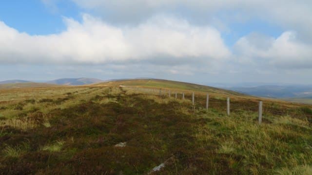
Black Law sits east of Talla Reservoir on the inner watershed, a small handful of stones beside the boundary fence marking the top. The name is common in the Borders for any dark heathery rise — and this one fits the bill.
Quick facts
- Height
- 698m/ 2290ft
- Prominence
- 103 m
- Distance
- ~13 km
- Ascent
- ~572 m
- Time
- 3–6 hrs
- Grid ref
- NT222279
- Parking
- NT232299
- Nearest city
- Edinburgh· 46km
- Dogs
- Dogs on lead required near livestockDog-friendly guide ↗
Height and prominence cross-checked against the Database of British and Irish Hills (CC BY).
No GPX track yet
Walked this route? Share your track to help other walkers.
Standard route
grass moorland 80% · heather patches 15% · summit area 5%
Most often picked up as part of the Manor–Tweedsmuir round; the shortest standalone ascent is from the road end at Stanhope, climbing through bracken and onto the grassy crest of Long Grain Knowe.
Terrain
Mostly heather above the bracken band — calf-deep in places where managed burning is overdue. The ridge fence guides the walker along the crest.
In winter
Heather under snow is exhausting to push through. After a freeze the going firms up quickly. Watch for hidden boulders below the cairn — they tend to grab crampon points in shallow cover.
Kit for this: the winter Munro kit list · which boots take crampons
Best time of year
Getting there
- Glasgow2h 44m
- Edinburgh1h 6m
OS maps: OS Landranger 73
Mobile signal: Reliable up top; EE holds throughout. Smooth Southern Uplands grass hill.
Current conditions
Daylight Today
- Sunrise
- 07:41
- Sunset
- 18:17
- Civil dawn
- 07:04
- Civil dusk
- 18:54
NOAA Solar Calculator · 14 October 2026
Around Black Law on the SCOT network
Getting there, basing yourself, and what to do off the hill.
Black Law — common questions
- How difficult is Black Law?
- Black Law carries a 3/5 (moderately challenging) grade on the OutdoorSCOT scale. Count on about 13km, 572m of ascent and a 3-6 hour day on the standard route. Terrain: Mostly heather above the bracken band — calf-deep in places where managed burning is overdue.
- How prominent is Black Law?
- Black Law has 103m of topographic prominence — the height of its summit above the highest col connecting it to higher ground.
- Where should I park to climb Black Law?
- Standard parking is at NT232299. Check the parking grid reference on an OS map before travel; informal laybys can fill on summer weekends.
- When should I climb Black Law?
- The standard good-weather months for Black Law are March, April, May, June, July, August, September, October, November. Outside those months, expect winter conditions on the high ground — full mountain kit, navigation skills, and a check of the SAIS avalanche forecast for the relevant region.
- Can I bring my dog up Black Law?
- On a lead only — the route crosses ground with livestock or nesting-bird interest.
- What's mobile reception like on Black Law?
- Reliable up top; EE holds throughout. Smooth Southern Uplands grass hill.
- Is Black Law safe in winter?
- Heather under snow is exhausting to push through. After a freeze the going firms up quickly. Watch for hidden boulders below the cairn — they tend to grab crampon points in shallow cover.
Get the OutdoorSCOT weekly
One email a week — new route, hill and bothy guides, seasonal conditions and the odd hard-won lesson. No spam, unsubscribe in one click.