Donald · Borders
Glenrath Heights
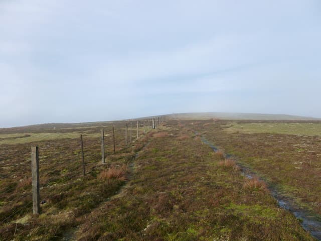
Glenrath Heights crowns the east arm of the Glenrath Horseshoe, joining the Dollar Law plateau to the Glensax ridge above Peebles. A small heap of stones beside the boundary fence is all that marks the watershed. Walkers tag it as part of the bigger Manor round.
Quick facts
- Height
- 730.5m/ 2397ft
- Prominence
- 87 m
- Distance
- 13 km
- Ascent
- 599 m
- Time
- 3–6 hrs
- Grid ref
- NT241322
- Parking
- NT243315
- Nearest city
- Edinburgh· 42km
- Dogs
- Dogs on lead required near livestockDog-friendly guide ↗
Height and prominence cross-checked against the Database of British and Irish Hills (CC BY).
No GPX track yet
Walked this route? Share your track to help other walkers.
Standard route
grass moorland 80% · heather patches 15% · summit area 5%
From the road end at Glenrath Hope, follow the burn into the corrie before climbing onto the north ridge over Black Law. The fence carries you west to Dun Rig or south to Dollar Law for the full horseshoe.
Terrain
Hard sheep tracks weave through tussocky moor grass on the upper plateau. The boundary wire is the dependable guide line. Lower down a shepherds' quad route follows the burn.
In winter
Sits high on the inland watershed and catches snow showers off both coasts; one of the slightly snowier Manor tops. The cairn-like marker disappears under a few centimetres of drift — note the bearing off it before pressing on.
Best time of year
Getting there
- Glasgow2h 44m
- Edinburgh1h 0m
OS maps: OS Landranger 73
Current conditions
Daylight Today
- Sunrise
- 04:47
- Sunset
- 21:50
- Civil dawn
- 03:52
- Civil dusk
- 22:45
NOAA Solar Calculator · 13 July 2026
Around Glenrath Heights on the SCOT network
Getting there, basing yourself, and what to do off the hill.
Glenrath Heights — common questions
- How difficult is Glenrath Heights?
- Glenrath Heights carries a 3/5 (moderately challenging) grade on the OutdoorSCOT scale. Count on about 13km, 599m of ascent and a 3-6 hour day on the standard route. Ground conditions: Hard sheep tracks weave through tussocky moor grass on the upper plateau.
- How much drop does Glenrath Heights have?
- The drop is 87m: measured from the summit of Glenrath Heights down to the saddle joining it to higher terrain.
- Where's the parking for Glenrath Heights?
- Park at NT243315. Double-check the grid reference on an OS map first; informal laybys here fill early in high season.
- What's the best month to climb Glenrath Heights?
- Aim for April, May, June, July, August, September, October on Glenrath Heights. In the remaining months treat it as a winter hill — full kit, solid navigation, and a look at the relevant SAIS avalanche forecast before you go.
- Can dogs go up Glenrath Heights?
- Dogs are fine on a lead. The route passes livestock or ground-nesting bird habitat, so keep them close throughout.
- Is Glenrath Heights safe in winter?
- Sits high on the inland watershed and catches snow showers off both coasts; one of the slightly snowier Manor tops. The cairn-like marker disappears under a few centimetres of drift — note the bearing off it before pressing on.
Get the OutdoorSCOT weekly
One email a week — new route, hill and bothy guides, seasonal conditions and the odd hard-won lesson. No spam, unsubscribe in one click.