Donald · Borders
Greenside Law
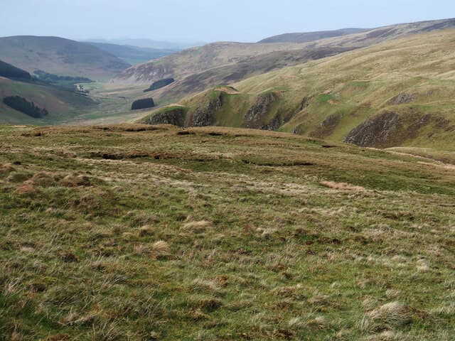
Greenside Law (643m) is a quiet whaleback in the Manor Hills west of St Mary's Loch, a tussocky dome above the headwaters of the Megget and Talla burns. The summit is unmarked — a patch of cropped grass among rougher tussock — and is most often reached as part of the long ridge sweep shared with Dollar Law and Black Law. Visitors come for the silence and the long views east over the upper Yarrow.
Quick facts
- Height
- 643m/ 2110ft
- Prominence
- 77 m
- Distance
- 12 km
- Ascent
- 482 m
- Time
- 3–5 hrs
- Grid ref
- NT197256
- Parking
- NT151206
- Nearest city
- Edinburgh· 49km
- Dogs
- Dogs on lead required near livestockDog-friendly guide ↗
Height and prominence cross-checked against the Database of British and Irish Hills (CC BY).
No GPX track yet
Walked this route? Share your track to help other walkers.
Standard route
grass moorland 80% · heather patches 15% · summit area 5%
From the Megget Stone parking area at NT151206 a quad-bike track climbs the steep prow of Hunt Law before easing out onto the broad Cramalt Craig ridge. Greenside Law lies further east beyond a shallow saddle of peat hags, 12km return with 482m ascent. The ground is cropped sheep grass interlaced with hag systems that turn to porridge after rain. Return by the outward ridge.
Terrain
Short cropped grass dominates the ridge, but the watershed is broken by deep peat hags that braid the line of march. There are no waymarks and the summit itself is anonymous — a GPS or compass-and-pace approach is wise off the obvious ridge crest. The Megget Stone marks the start and is a useful catching feature on return.
In winter
In winter the Manor watershed feels much higher than 643m. Snow drifts settle deep in the peat hags and freeze hard into ankle-trapping pockets, while wind funnels through the gap above Talla Reservoir. SAIS Southern Uplands rarely issues bulletins this far east, but cornices can build along the steep northern edge dropping into the Megget cleuchs.
Best time of year
Getting there
- Glasgow2h 43m
- Edinburgh1h 9m
OS maps: OS Landranger 72
Mobile signal: Signal is good; EE reliable. Southern Uplands viewpoint.
Current conditions
Daylight Today
- Sunrise
- 04:54
- Sunset
- 21:45
- Civil dawn
- 04:00
- Civil dusk
- 22:38
NOAA Solar Calculator · 17 July 2026
Around Greenside Law on the SCOT network
Getting there, basing yourself, and what to do off the hill.
Greenside Law — common questions
- How hard is Greenside Law?
- We grade Greenside Law at 3/5, which puts it in moderately challenging territory. The usual route is around 12km with 482m of climbing; allow 3-5 hours. Terrain: Short cropped grass dominates the ridge, but the watershed is broken by deep peat hags that braid the line of march.
- How prominent is Greenside Law?
- Greenside Law has 77m of topographic prominence — the height of its summit above the highest col connecting it to higher ground.
- Where should I park to climb Greenside Law?
- Standard parking is at NT151206. Check the parking grid reference on an OS map before travel; informal laybys can fill on summer weekends.
- When should I climb Greenside Law?
- The standard good-weather months for Greenside Law are March, April, May, June, July, August, September, October, November. Outside those months, expect winter conditions on the high ground — full mountain kit, navigation skills, and a check of the SAIS avalanche forecast for the relevant region.
- Can I bring my dog up Greenside Law?
- On a lead only — the route crosses ground with livestock or nesting-bird interest.
- What's mobile reception like on Greenside Law?
- Signal is good; EE reliable. Southern Uplands viewpoint.
- Is Greenside Law safe in winter?
- In winter the Manor watershed feels much higher than 643m. Snow drifts settle deep in the peat hags and freeze hard into ankle-trapping pockets, while wind funnels through the gap above Talla Reservoir. SAIS Southern Uplands rarely issues bulletins this far east, but cornices can build along the steep northern edge dropping into the Megget cleuchs.
Get the OutdoorSCOT weekly
One email a week — new route, hill and bothy guides, seasonal conditions and the odd hard-won lesson. No spam, unsubscribe in one click.