Donald · Galloway
Millfore
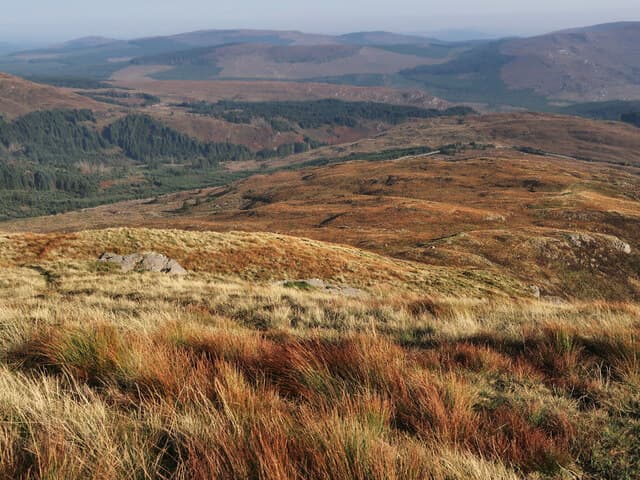
Millfore sits in the wild moorland heart of the Minnigaff range, west of Loch Dee. The summit is a low band of layered rock — almost a small tor — with views across to the Awful Hand and out over Cairnsmore of Fleet.
Quick facts
- Height
- 657m/ 2156ft
- Prominence
- 250 m
- Distance
- 13 km
- Ascent
- 539 m
- Time
- 3–6 hrs
- Grid ref
- NX478754
- Parking
- NX458760
- Nearest city
- Dumfries· 50km
- Dogs
- Dogs on lead required near livestockDog-friendly guide ↗
Height and prominence cross-checked against the Database of British and Irish Hills (CC BY).
No GPX track yet
Walked this route? Share your track to help other walkers.
Standard route
heather moorland 60% · grass moorland 30% · rocky outcrops 10%
From the Black Loch car park or the Loch Dee track, follow the forest road east before breaking onto open heather and bog. Around 14km return with 540m of climb.
Terrain
Wet heather, broken peat, and granite slabs — typical inner Galloway terrain. No clear path above the forest road.
In winter
Galloway granite holds black ice. Verglas on the slabby summit is a regular hazard in freeze-thaw weather.
Best time of year
Getting there
- Glasgow2h 56m
- Edinburgh3h 40m
OS maps: OS Landranger 77
Mobile signal: Moderate. EE in and out; stronger toward Newton Stewart.
Current conditions
Daylight Today
- Sunrise
- 04:55
- Sunset
- 21:51
- Civil dawn
- 04:02
- Civil dusk
- 22:45
NOAA Solar Calculator · 13 July 2026
Pair with
Curated multi-hill combinations from Millfore.
Around Millfore on the SCOT network
Getting there, basing yourself, and what to do off the hill.
Getting there: Ayr station
Ayrshire coast; Galloway approach via bus/car
49km from the hill
tripscot.co.uk
On TripSCOTBase yourself in Kirkcudbright
Galloway base — Solway coast, Galloway Forest, Mull of Galloway Trail
32km from the hill
tripscot.co.uk
On TasteSCOTAfter the hill: Bladnoch
Wigtown — Galloway's only distillery; Scotland's most southerly
22km from the hill
tastescot.co.uk
Millfore — common questions
- How difficult is Millfore?
- Millfore carries a 3/5 (moderately challenging) grade on the OutdoorSCOT scale. Count on about 13km, 539m of ascent and a 3-6 hour day on the standard route. Terrain: Wet heather, broken peat, and granite slabs — typical inner Galloway terrain.
- How prominent is Millfore?
- Millfore has 250m of topographic prominence — the height of its summit above the highest col connecting it to higher ground.
- Where should I park to climb Millfore?
- Standard parking is at NX458760. Check the parking grid reference on an OS map before travel; informal laybys can fill on summer weekends.
- When should I climb Millfore?
- The standard good-weather months for Millfore are March, April, May, June, July, August, September, October, November. Outside those months, expect winter conditions on the high ground — full mountain kit, navigation skills, and a check of the SAIS avalanche forecast for the relevant region.
- Can I bring my dog up Millfore?
- On a lead only — the route crosses ground with livestock or nesting-bird interest.
- What's mobile reception like on Millfore?
- Moderate. EE in and out; stronger toward Newton Stewart.
- Is Millfore safe in winter?
- Galloway granite holds black ice. Verglas on the slabby summit is a regular hazard in freeze-thaw weather.
Get the OutdoorSCOT weekly
One email a week — new route, hill and bothy guides, seasonal conditions and the odd hard-won lesson. No spam, unsubscribe in one click.