Donald · Galloway
Meikle Millyea
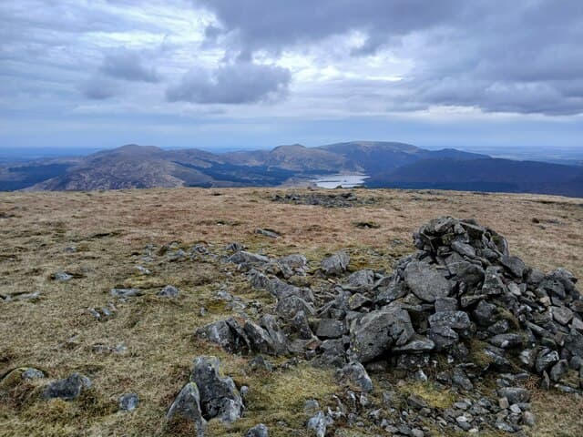
The southern bookend of the Rhinns of Kells, Meikle Millyea sits at the head of the Polharrow Burn looking out across the Galloway Dark Sky Park towards Cairnsmore of Fleet. A flat lichen-streaked summit slab gives the high point a slightly unfinished feel.
Quick facts
- Height
- 748.64m/ 2456ft
- Prominence
- 121 m
- Distance
- 14 km
- Ascent
- 613 m
- Time
- 4–7 hrs
- Grid ref
- NX516825
- Parking
- NX502855
- Nearest city
- Dumfries· 46km
- Dogs
- Dogs on lead required near livestockDog-friendly guide ↗
Height and prominence cross-checked against the Database of British and Irish Hills (CC BY).
No GPX track yet
Walked this route? Share your track to help other walkers.
Standard route
heather moorland 55% · granite boulders 30% · grass moorland 15%
Start from Forrest Lodge and either tackle the south ridge direct from the Polharrow forest road, or include it at the end of a full Rhinns of Kells traverse coming down from Corserine.
Terrain
Forest road for the first 4 km, then rough tussock and bog up onto Milldown of Cairnsmore before easy slabs to the top. The plateau is broad and confusing without map and compass to hand.
In winter
Once cold weather grips the Galloway uplands the bog freezes hard and the going turns rapid; in mild winters the same ground is shin-deep mud. Hill fog tends to dump down off the Atlantic with little warning.
Best time of year
Getting there
- Glasgow2h 46m
- Edinburgh3h 30m
OS maps: OS Landranger 77
Mobile signal: Moderate. EE unreliable on top; limited coverage in the Rhinns of Kells area.
Current conditions
Daylight Today
- Sunrise
- 04:55
- Sunset
- 21:51
- Civil dawn
- 04:01
- Civil dusk
- 22:45
NOAA Solar Calculator · 13 July 2026
Around Meikle Millyea on the SCOT network
Getting there, basing yourself, and what to do off the hill.
Getting there: Ayr station
Ayrshire coast; Galloway approach via bus/car
43km from the hill
tripscot.co.uk
On TripSCOTBase yourself in Kirkcudbright
Galloway base — Solway coast, Galloway Forest, Mull of Galloway Trail
36km from the hill
tripscot.co.uk
On TasteSCOTAfter the hill: Bladnoch
Wigtown — Galloway's only distillery; Scotland's most southerly
30km from the hill
tastescot.co.uk
Meikle Millyea — common questions
- Is Meikle Millyea a hard climb?
- Meikle Millyea is rated 4/5 (challenging) on the OutdoorSCOT scale. The standard route covers about 14km with 613m of ascent and takes most walkers 4-7 hours. Ground conditions: Forest road for the first 4 km, then rough tussock and bog up onto Milldown of Cairnsmore before easy slabs to the top.
- How much drop does Meikle Millyea have?
- The drop is 121m: measured from the summit of Meikle Millyea down to the saddle joining it to higher terrain.
- Where's the parking for Meikle Millyea?
- Park at NX502855. Double-check the grid reference on an OS map first; informal laybys here fill early in high season.
- What's the best month to climb Meikle Millyea?
- Aim for April, May, June, July, August, September, October on Meikle Millyea. In the remaining months treat it as a winter hill — full kit, solid navigation, and a look at the relevant SAIS avalanche forecast before you go.
- Can dogs go up Meikle Millyea?
- Dogs are fine on a lead. The route passes livestock or ground-nesting bird habitat, so keep them close throughout.
- Will I get phone signal on Meikle Millyea?
- Moderate. EE unreliable on top; limited coverage in the Rhinns of Kells area.
- Is Meikle Millyea safe in winter?
- Once cold weather grips the Galloway uplands the bog freezes hard and the going turns rapid; in mild winters the same ground is shin-deep mud. Hill fog tends to dump down off the Atlantic with little warning.
Get the OutdoorSCOT weekly
One email a week — new route, hill and bothy guides, seasonal conditions and the odd hard-won lesson. No spam, unsubscribe in one click.