Donald · Galloway
Dungeon Hill
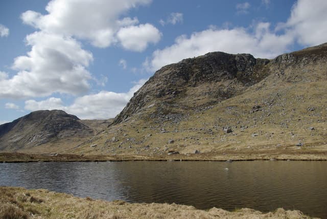
Dungeon Hill (620m) lies at the heart of the Dungeon of Buchan, the rough, lochan-pocked wilderness between the Awful Hand and the Rhinns of Kells. A bare rock slab marks the summit. This is one of the loneliest Donalds — the nearest road is hours away on foot, and the Round Loch of the Dungeon, Loch Neldricken and Murder Hole lie in the basin below. Linked southwards to Craignaw and northwards to Mullwharchar.
Quick facts
- Height
- 620.9m/ 2037ft
- Prominence
- 116 m
- Distance
- 12 km
- Ascent
- 465 m
- Time
- 3–5 hrs
- Grid ref
- NX460850
- Parking
- NX442846
- Nearest city
- Dumfries· 52km
- Dogs
- Dogs on lead required near livestockDog-friendly guide ↗
Height and prominence cross-checked against the Database of British and Irish Hills (CC BY).
No GPX track yet
Walked this route? Share your track to help other walkers.
Standard route
granite boulders 40% · heather moorland 40% · bog and grass 20%
The classic approach comes from Bruce's Stone at Loch Trool (NX415803), tracking north past Loch Valley and Loch Neldricken before scrambling onto Dungeon's slabby south ridge. The day is 12km return with 465m of ascent over slabs, granite boulder fields, deep heather and bog. The Awful Hand traverse can be tagged on, but Dungeon Hill alone makes a full Galloway day given the rough terrain.
Terrain
Granite slabs and boulder fields dominate the upper hill — characterful but slow underfoot, especially in wet weather when the lichen-coated slabs become slick. The lower approach is heather and tussock bog around the lochs of the Dungeon. No clear paths; route-finding among the slabs is a navigational exercise in its own right.
In winter
The Dungeon basin lies at the snowy heart of Galloway and Dungeon Hill's slabs grow extensive verglas in cold spells, including bona fide winter routes on the eastern crags above Loch Enoch. The lochans freeze hard but the surrounding bog rarely does, and the rough granite makes a navigational maze in whiteout. Carry full winter kit — escape is slow from this remoteness.
Best time of year
Getting there
- Glasgow2h 44m
- Edinburgh3h 32m
OS maps: OS Landranger 77
Mobile signal: Poor. Remote central Galloway; limited coverage in this area.
Current conditions
Daylight Today
- Sunrise
- 04:55
- Sunset
- 21:52
- Civil dawn
- 04:01
- Civil dusk
- 22:46
NOAA Solar Calculator · 13 July 2026
Pair with
Curated multi-hill combinations from Dungeon Hill.
Around Dungeon Hill on the SCOT network
Getting there, basing yourself, and what to do off the hill.
Dungeon Hill — common questions
- How difficult is Dungeon Hill?
- Dungeon Hill carries a 3/5 (moderately challenging) grade on the OutdoorSCOT scale. Count on about 12km, 465m of ascent and a 3-5 hour day on the standard route. Underfoot: Granite slabs and boulder fields dominate the upper hill — characterful but slow underfoot, especially in wet weather when the lichen-coated slabs become slick.
- What is Dungeon Hill's prominence?
- 116m of prominence. That's the vertical drop from the summit to the col that links Dungeon Hill to the next higher ground.
- Where do I park for Dungeon Hill?
- Most walkers start from NX442846. Verify the grid reference on an OS map before you set off — space is tight on busy summer weekends.
- When is the best time to climb Dungeon Hill?
- March, April, May, June, July, August, September, October, November give the most reliable conditions on Dungeon Hill. Beyond that window the high ground turns wintry: carry full mountain kit, be confident navigating, and check the SAIS avalanche forecast for the area.
- Is Dungeon Hill dog-friendly?
- Yes, but dogs must be kept on a lead — there is livestock or ground-nesting bird interest on the route.
- Is there mobile signal on Dungeon Hill?
- Poor. Remote central Galloway; limited coverage in this area.
- Is Dungeon Hill safe in winter?
- The Dungeon basin lies at the snowy heart of Galloway and Dungeon Hill's slabs grow extensive verglas in cold spells, including bona fide winter routes on the eastern crags above Loch Enoch. The lochans freeze hard but the surrounding bog rarely does, and the rough granite makes a navigational maze in whiteout. Carry full winter kit — escape is slow from this remoteness.
Get the OutdoorSCOT weekly
One email a week — new route, hill and bothy guides, seasonal conditions and the odd hard-won lesson. No spam, unsubscribe in one click.