Donald · Galloway
Milldown
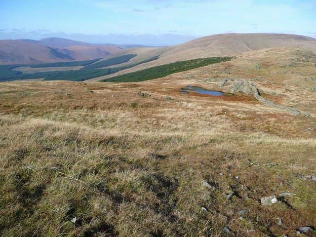
Milldown lies on the southern Kells ridge between Meikle Millyea and Millfire, a low rocky outcrop on a broad plateau of close-cropped grass. A great place for hares — they bolt from underfoot in late summer when the bracken below is at its rankest.
Quick facts
- Height
- 738m/ 2421ft
- Prominence
- 90 m
- Distance
- 14 km
- Ascent
- 605 m
- Time
- 4–6 hrs
- Grid ref
- NX511839
- Parking
- NX512833
- Nearest city
- Dumfries· 47km
- Dogs
- Dogs on lead required near livestockDog-friendly guide ↗
Height and prominence cross-checked against the Database of British and Irish Hills (CC BY).
No GPX track yet
Walked this route? Share your track to help other walkers.
Standard route
heather moorland 65% · grass moorland 25% · rocky summit 10%
Almost always taken in as part of the full Rhinns of Kells ridge walk from Forrest Lodge, sandwiched between Meikle Millyea to the south and Corserine to the north. The outcrop is easily missed in cloud unless you take a bearing.
Terrain
A short cropped sward over granite slabs makes for excellent walking on the ridge itself. Below the plateau a confusing mosaic of bog, bracken and felled timber needs care — keep to obvious fire-breaks.
In winter
In a cold snap the plateau becomes ideal walking — frozen turf and rock under crampons. Wet snow over heather lower down is exhausting. Watch the western edge for the small cornice formations that build in north-west winds.
Best time of year
Getting there
- Glasgow2h 44m
- Edinburgh2h 29m
OS maps: OS Landranger 77
Mobile signal: Variable. EE fitful up top; stronger toward Newton Stewart.
Current conditions
Daylight Today
- Sunrise
- 04:55
- Sunset
- 21:51
- Civil dawn
- 04:01
- Civil dusk
- 22:45
NOAA Solar Calculator · 13 July 2026
Around Milldown on the SCOT network
Getting there, basing yourself, and what to do off the hill.
Milldown — common questions
- What difficulty is Milldown?
- On the OutdoorSCOT scale, Milldown comes in at 3/5 — moderately challenging. Expect roughly 14km and 605m of ascent on the usual route — 4-6 hours for most parties. Terrain: A short cropped sward over granite slabs makes for excellent walking on the ridge itself.
- How prominent is Milldown?
- Milldown has 90m of topographic prominence — the height of its summit above the highest col connecting it to higher ground.
- Where should I park to climb Milldown?
- Standard parking is at NX512833. Check the parking grid reference on an OS map before travel; informal laybys can fill on summer weekends.
- When should I climb Milldown?
- The standard good-weather months for Milldown are April, May, June, July, August, September, October. Outside those months, expect winter conditions on the high ground — full mountain kit, navigation skills, and a check of the SAIS avalanche forecast for the relevant region.
- Can I bring my dog up Milldown?
- On a lead only — the route crosses ground with livestock or nesting-bird interest.
- What's mobile reception like on Milldown?
- Variable. EE fitful up top; stronger toward Newton Stewart.
- Is Milldown safe in winter?
- In a cold snap the plateau becomes ideal walking — frozen turf and rock under crampons. Wet snow over heather lower down is exhausting. Watch the western edge for the small cornice formations that build in north-west winds.
Get the OutdoorSCOT weekly
One email a week — new route, hill and bothy guides, seasonal conditions and the odd hard-won lesson. No spam, unsubscribe in one click.