Donald · Galloway
Carlin's Cairn
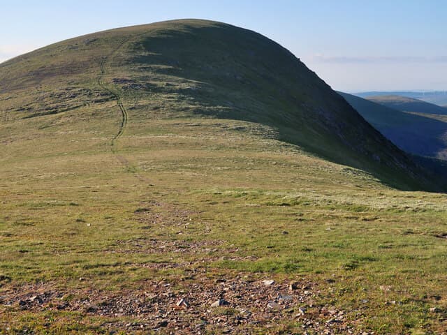
A close neighbour of Corserine on the Rhinns of Kells, Carlin's Cairn carries one of the most impressive summit cairns in Galloway — a great drystone tower said to have been raised by an old woman in gratitude to Robert the Bruce. The view west to the Awful Hand of Merrick is superb.
Quick facts
- Height
- 807m/ 2648ft
- Prominence
- 99 m
- Distance
- 15 km
- Ascent
- 710 m
- Time
- 4–7 hrs
- Grid ref
- NX496883
- Parking
- NX497877
- Nearest city
- Dumfries· 49km
- Dogs
- Dogs on lead required near livestockDog-friendly guide ↗
Height and prominence cross-checked against the Database of British and Irish Hills (CC BY).
No GPX track yet
Walked this route? Share your track to help other walkers.
Standard route
heather moorland 50% · granite boulders 35% · grass moorland 15%
The usual line is from Forrest Lodge near Loch Doon, taking the forest road past Loch Harrow before climbing onto the ridge. The natural continuation is south to Corserine, returning by the same forest gate.
Terrain
Heather and tussock on the lower ground gives way to neat grass and granite slabs on the ridge. The Kells boundary fence makes a useful guide between Carlin's Cairn and Corserine in dud weather.
In winter
Galloway snow rarely settles deep at this altitude but rime ice can plaster the summit cairn for days at a time. The boggy approach freezes solid in a cold spell — boots crunch over what is normally a long wet slog.
Best time of year
Getting there
- Glasgow2h 51m
- Edinburgh2h 26m
OS maps: OS Landranger 77
Mobile signal: Patchy. EE intermittent up top; better on south-facing slopes.
Current conditions
Daylight Today
- Sunrise
- 04:55
- Sunset
- 21:52
- Civil dawn
- 04:01
- Civil dusk
- 22:46
NOAA Solar Calculator · 13 July 2026
Pair with
Curated multi-hill combinations from Carlin's Cairn.
Around Carlin's Cairn on the SCOT network
Getting there, basing yourself, and what to do off the hill.
Carlin's Cairn — common questions
- How difficult is Carlin's Cairn?
- Carlin's Cairn carries a 4/5 (challenging) grade on the OutdoorSCOT scale. Count on about 15km, 710m of ascent and a 4-7 hour day on the standard route. Underfoot: Heather and tussock on the lower ground gives way to neat grass and granite slabs on the ridge.
- What is Carlin's Cairn's prominence?
- 99m of prominence. That's the vertical drop from the summit to the col that links Carlin's Cairn to the next higher ground.
- Where do I park for Carlin's Cairn?
- Most walkers start from NX497877. Verify the grid reference on an OS map before you set off — space is tight on busy summer weekends.
- When is the best time to climb Carlin's Cairn?
- April, May, June, July, August, September, October give the most reliable conditions on Carlin's Cairn. Beyond that window the high ground turns wintry: carry full mountain kit, be confident navigating, and check the SAIS avalanche forecast for the area.
- Is Carlin's Cairn dog-friendly?
- Yes, but dogs must be kept on a lead — there is livestock or ground-nesting bird interest on the route.
- Is there mobile signal on Carlin's Cairn?
- Patchy. EE intermittent up top; better on south-facing slopes.
- Is Carlin's Cairn safe in winter?
- Galloway snow rarely settles deep at this altitude but rime ice can plaster the summit cairn for days at a time. The boggy approach freezes solid in a cold spell — boots crunch over what is normally a long wet slog.
Get the OutdoorSCOT weekly
One email a week — new route, hill and bothy guides, seasonal conditions and the odd hard-won lesson. No spam, unsubscribe in one click.