Donald · Galloway
Coran of Portmark (Corran of Portmark)
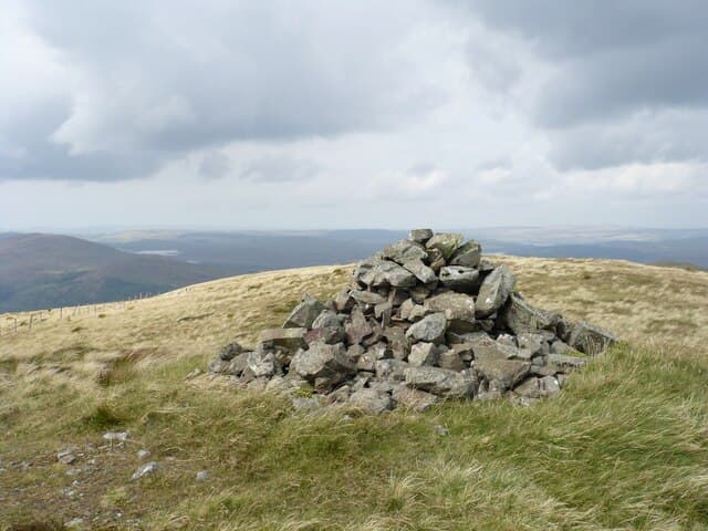
Coran of Portmark (623m) is the northernmost summit of the Rhinns of Kells ridge in the Galloway Hills, looking down on Loch Doon and the Carrick Forest. A small cairn caps the granite top, with the rough whaleback continuing south to Bow and Meaul. The Glenkens and the Solway open out to the south — on clear days the Isle of Man sits low on the horizon beyond the firth.
Quick facts
- Height
- 623m/ 2044ft
- Prominence
- 61 m
- Distance
- 12 km
- Ascent
- 467 m
- Time
- 3–5 hrs
- Grid ref
- NX509936
- Parking
- NX502922
- Nearest city
- Dumfries· 50km
- Dogs
- Dogs on lead required near livestockDog-friendly guide ↗
Height and prominence cross-checked against the Database of British and Irish Hills (CC BY).
No GPX track yet
Walked this route? Share your track to help other walkers.
Standard route
heather moorland 60% · grass moorland 30% · rocky outcrops 10%
From the Loch Doon dam at NX475951 follow the lochside road and forestry track east through the plantation to break out onto the open hill near Eglin Lane. A direct climb up the steep north-west ridge gives 12km and 467m of ascent on heather, granite slabs and short grass. The summit cairn is exposed; many parties continue south along the Kells ridge to Meaul before descending Eglin Lane.
Terrain
The forestry approach can be muddy and re-route signs appear after felling — keep an eye on Forestry and Land Scotland updates. Above the trees the ground is the classic Galloway mix of granite slabs, deep heather and bog. The Kells ridge crest is well-defined but the descent into the Doon basin is path-free and quickly disorienting in mist.
In winter
The Galloway granite holds ice when the wider Southern Uplands have melted out, and the Kells ridge can give surprisingly serious winter outings. Verglas glazes the slabs after thaw–freeze cycles; the steep north-west face above Loch Doon ices hard. Whiteouts blowing in off the Solway can blank out the ridge crest, and self-rescue is slow once committed.
Best time of year
Getting there
- Glasgow2h 43m
- Edinburgh2h 20m
OS maps: OS Landranger 77
Mobile signal: Mixed. EE fitful up top; coverage limited north of Ken Valley.
Current conditions
Daylight Today
- Sunrise
- 05:00
- Sunset
- 21:47
- Civil dawn
- 04:07
- Civil dusk
- 22:40
NOAA Solar Calculator · 17 July 2026
Got a photo of Coran of Portmark (Corran of Portmark)?
30 seconds, helps other walkers.
Submit a photoAround Coran of Portmark (Corran of Portmark) on the SCOT network
Getting there, basing yourself, and what to do off the hill.
Coran of Portmark (Corran of Portmark) — common questions
- Is Coran of Portmark (Corran of Portmark) a hard climb?
- Coran of Portmark (Corran of Portmark) is rated 3/5 (moderately challenging) on the OutdoorSCOT scale. The standard route covers about 12km with 467m of ascent and takes most walkers 3-5 hours. Underfoot: The forestry approach can be muddy and re-route signs appear after felling — keep an eye on Forestry and Land Scotland updates.
- What is Coran of Portmark (Corran of Portmark)'s prominence?
- 61m of prominence. That's the vertical drop from the summit to the col that links Coran of Portmark (Corran of Portmark) to the next higher ground.
- Where do I park for Coran of Portmark (Corran of Portmark)?
- Most walkers start from NX502922. Verify the grid reference on an OS map before you set off — space is tight on busy summer weekends.
- When is the best time to climb Coran of Portmark (Corran of Portmark)?
- March, April, May, June, July, August, September, October, November give the most reliable conditions on Coran of Portmark (Corran of Portmark). Beyond that window the high ground turns wintry: carry full mountain kit, be confident navigating, and check the SAIS avalanche forecast for the area.
- Is Coran of Portmark (Corran of Portmark) dog-friendly?
- Yes, but dogs must be kept on a lead — there is livestock or ground-nesting bird interest on the route.
- Is there mobile signal on Coran of Portmark (Corran of Portmark)?
- Mixed. EE fitful up top; coverage limited north of Ken Valley.
- Is Coran of Portmark (Corran of Portmark) safe in winter?
- The Galloway granite holds ice when the wider Southern Uplands have melted out, and the Kells ridge can give surprisingly serious winter outings. Verglas glazes the slabs after thaw–freeze cycles; the steep north-west face above Loch Doon ices hard. Whiteouts blowing in off the Solway can blank out the ridge crest, and self-rescue is slow once committed.
Get the OutdoorSCOT weekly
One email a week — new route, hill and bothy guides, seasonal conditions and the odd hard-won lesson. No spam, unsubscribe in one click.