Corbett · Argyll & Bute
Beinn Bhuidhe
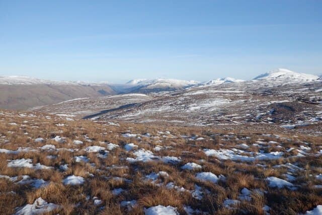
Beinn Bhuidhe — 'the yellow hill' — is the great isolated Corbett rising between Loch Fyne and Glen Shira above the head of the loch, with the longest standard approach of any Corbett in the southern Highlands. The 901m summit sits behind a 10km walk-in up Glen Fyne, which is most efficiently bagged on a bike. The long approach has the effect of keeping the mountain quiet even in good weather, and the summit ridge gives a fine front-row view across to Ben Lui, Beinn an Lochain and Loch Awe.
Quick facts
- Height
- 901m/ 2956ft
- Distance
- 24 km
- Ascent
- 950 m
- Time
- 6–10 hrs
- Grid ref
- NN203187
- Parking
- NN196127
- Nearest city
- Oban
- Dogs
- Dogs on lead required near livestockDog-friendly guide ↗
No GPX track yet
Walked this route? Share your track to help other walkers.
Standard route
glen track 35% · open hillside 30% · steep grass 25% · rocky summit 10%
Park at the small layby at the head of Loch Fyne near Cairndow (NN196127). Walk or cycle up the Glen Fyne hydro track for around 10km to a small bridge near the head of the glen. Leave the track here and climb steeply north-west onto the south-east flank of Beinn Bhuidhe, picking a line up grass to gain the upper ridge. The summit cairn is a short walk west along the broad top. Allow 8–9 hours on foot, 6 with a bike.
Terrain
Excellent hydro/estate track for the long approach — easy walking, faster cycling. Above the track the going is steep grass with a few peat hags, slow on the climb and surprisingly tough on the descent. The broad summit dome has no landmarks of consequence; in cloud, accurate bearings off the top matter.
In winter
The walk-in's length makes a winter Beinn Bhuidhe a long day even with bike — and the bike becomes a liability once the track ices up. Snow lies well on the summit plateau from January through March. The upper grass face holds wind slab in lee aspects. Plan for early starts and headtorches at both ends.
Best time of year
Getting there
- Glasgow2h 45m
- Edinburgh3h 30m
OS maps: OS Explorer 364
Mobile signal: No signal for most of the approach; brief 1-bar on the summit in clear conditions
Current conditions
Daylight Today
- Sunrise
- 04:41
- Sunset
- 21:54
- Civil dawn
- 03:42
- Civil dusk
- 22:53
NOAA Solar Calculator · 31 May 2026
Pair with
Curated multi-hill combinations from Beinn Bhuidhe.
Around Beinn Bhuidhe on the SCOT network
Getting there, basing yourself, and what to do off the hill.
Beinn Bhuidhe — common questions
- How hard is Beinn Bhuidhe?
- Beinn Bhuidhe is rated 3/5 (moderately challenging) on the OutdoorSCOT scale. The standard route covers about 24km with 950m of ascent and takes most walkers 6-10 hours. Terrain: Excellent hydro/estate track for the long approach — easy walking, faster cycling.
- Where do I park for Beinn Bhuidhe?
- Standard parking is at NN196127 near Glasgow. Check the parking grid reference on an OS map before travel; informal laybys can fill on summer weekends.
- When is the best time to climb Beinn Bhuidhe?
- The standard good-weather months for Beinn Bhuidhe are May, June, July, August, September. Outside those months, expect winter conditions on the high ground — full mountain kit, navigation skills, and a check of the SAIS avalanche forecast for the relevant region.
- Can I bring my dog up Beinn Bhuidhe?
- Yes, but dogs must be kept on a lead — there is livestock or ground-nesting bird interest on the route.
- Is there mobile signal on Beinn Bhuidhe?
- No signal for most of the approach; brief 1-bar on the summit in clear conditions
- Is Beinn Bhuidhe safe in winter?
- The walk-in's length makes a winter Beinn Bhuidhe a long day even with bike — and the bike becomes a liability once the track ices up. Snow lies well on the summit plateau from January through March. The upper grass face holds wind slab in lee aspects. Plan for early starts and headtorches at both ends.