Munro · Kintail
Ladhar Bheinn
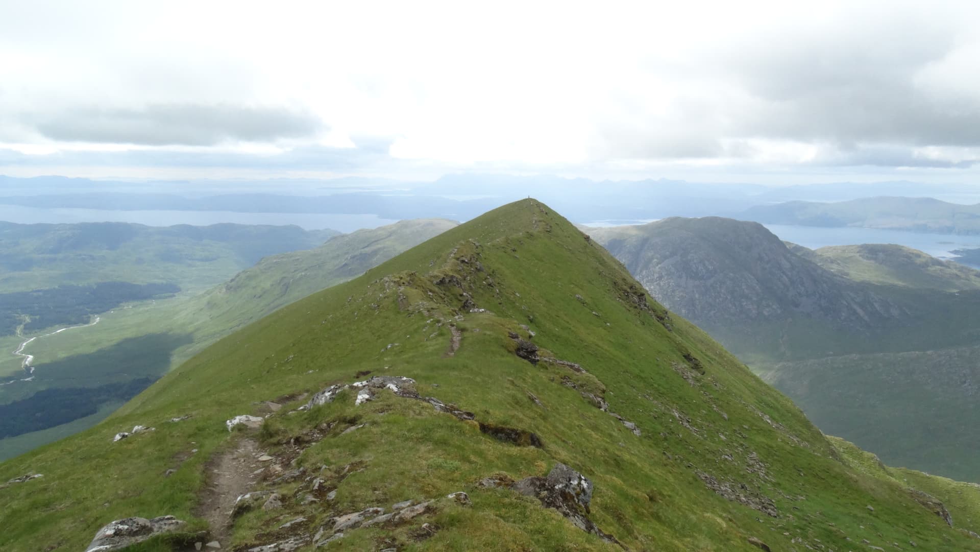
Ladhar Bheinn (1020m) — pronounced "Larven", "hoof mountain" — is the most westerly Munro on the British mainland and widely considered the most dramatically positioned of all Munros. The peak rises straight out of the sea-lochs of Knoydart, with no roads within 10km. Its west-facing corrie, Coire Dhorrcaill, is among the most spectacular in Scotland — a great Atlantic-facing amphitheatre with views to Skye, Rum, Eigg and the Outer Hebrides. A genuine adventure regardless of approach.
Quick facts
- Height
- 1020m/ 3346ft
- Prominence
- 795 m
- Distance
- ~17 km
- Ascent
- ~898 m
- Time
- 6–10 hrs
- Grid ref
- NG824039
- Parking
- NM764995
- Nearest city
- Fort William· 41km
- Dogs
- Dogs on lead required near livestockDog-friendly guide ↗
Height and prominence cross-checked against the Database of British and Irish Hills (CC BY).
No GPX track yet
Walked this route? Share your track to help other walkers.
Standard route
Glen path from Inverie 30% · Steep corrie approach 35% · Summit ridge 35%
Two main approaches. Most parties take the Western Isles ferry from Mallaig to Inverie (the village in Knoydart), then walk north-east up Gleann an Dubh-Lochain and over the high bealach to Coire Dhorrcaill, climbing the spectacular south-east ridge of Ladhar Bheinn. Alternative is a long walk-in from Kinloch Hourn via the rough coast path to Barrisdale Bay, then climbing direct from the north. Inverie return is 18km with 1100m of ascent — usually done as part of a 2–3 day Knoydart trip.
Terrain
The Inverie estate path through Gleann an Dubh-Lochain is firm in places, boggy in others. The climb to the high bealach is sustained on grass and broken rock. The south-east ridge of Ladhar Bheinn is the highlight — a narrow rocky crest with sustained airy exposure on both sides above Coire Dhorrcaill. The summit area is a small flat ridge with the cairn at the high point. The Barrisdale Bay coastal path is one of the rougher long walks in Scotland.
In winter
A serious, very remote winter Munro. Winter access via the Mallaig–Inverie ferry depends on weather and schedule. The south-east ridge becomes a Grade I/II winter climb; Coire Dhorrcaill itself holds Grade II–IV winter routes. There is no helicopter rescue stand-by in the immediate area. Phone signal is absent throughout Knoydart. Inverie has the Old Forge pub for shelter. Full self-sufficient mountaineering kit essential.
Kit for this: the winter Munro kit list · which boots take crampons
Best time of year
Getting there
- Glasgow3h 2m
- Edinburgh4h 43m
Ferry access
Mallaig → Inverie (Knoydart)
- Crossing time45 min
- Summer sailingsMon–Sat, 2–3 sailings daily (Apr–Oct, Western Isles Cruises)
- Winter sailingsMon/Wed/Fri only (Nov–Mar)
- Book ahead3 days
- Last ferry backLast ferry from Inverie ~17:30 (check Western Isles Cruises timetable)
Knoydart is a roadless peninsula — not an island, but accessible only by ferry or a very long walk (18+ km over difficult terrain). Day trips to Sgùrr Coire Choinnichean are achievable in summer. For Ladhar Bheinn, base yourself overnight at Inverie.
Book on ferry operator ↗OS maps: OS Landranger 33
Mobile signal: No signal in Knoydart — no roads, no masts. The ferry from Mallaig to Inverie has no coverage en route. Download maps at home in advance of the trip.
Current conditions
Daylight Today
- Sunrise
- 08:10
- Sunset
- 18:04
- Civil dawn
- 07:31
- Civil dusk
- 18:43
NOAA Solar Calculator · 22 October 2026
Pair with
Curated multi-hill combinations from Ladhar Bheinn.
Around Ladhar Bheinn on the SCOT network
Getting there, basing yourself, and what to do off the hill.
Ladhar Bheinn — common questions
- Is Ladhar Bheinn a hard climb?
- Ladhar Bheinn is rated 5/5 (very challenging) on the OutdoorSCOT scale. The standard route covers about 17km with 898m of ascent and takes most walkers 6-10 hours. Underfoot: The Inverie estate path through Gleann an Dubh-Lochain is firm in places, boggy in others.
- What is Ladhar Bheinn's prominence?
- 795m of prominence. That's the vertical drop from the summit to the col that links Ladhar Bheinn to the next higher ground.
- Where do I park for Ladhar Bheinn?
- Most walkers start from NM764995. Verify the grid reference on an OS map before you set off — space is tight on busy summer weekends.
- When is the best time to climb Ladhar Bheinn?
- May, June, July, August, September give the most reliable conditions on Ladhar Bheinn. Beyond that window the high ground turns wintry: carry full mountain kit, be confident navigating, and check the SAIS avalanche forecast for the area.
- Is Ladhar Bheinn dog-friendly?
- Yes, but dogs must be kept on a lead — there is livestock or ground-nesting bird interest on the route.
- Is there mobile signal on Ladhar Bheinn?
- No signal in Knoydart — no roads, no masts. The ferry from Mallaig to Inverie has no coverage en route. Download maps at home in advance of the trip.
- How do I get the ferry to Ladhar Bheinn?
- Mallaig → Inverie (Knoydart). Mon–Sat, 2–3 sailings daily (Apr–Oct, Western Isles Cruises) in summer; Mon/Wed/Fri only (Nov–Mar) in winter. Book at least 3 days ahead. Knoydart is a roadless peninsula — not an island, but accessible only by ferry or a very long walk (18+ km over difficult terrain). Day trips to Sgùrr Coire Choinnichean are achievable in summer. For Ladhar Bheinn, base yourself overnight at Inverie.
- Is Ladhar Bheinn safe in winter?
- A serious, very remote winter Munro. Winter access via the Mallaig–Inverie ferry depends on weather and schedule. The south-east ridge becomes a Grade I/II winter climb; Coire Dhorrcaill itself holds Grade II–IV winter routes. There is no helicopter rescue stand-by in the immediate area. Phone signal is absent throughout Knoydart. Inverie has the Old Forge pub for shelter. Full self-sufficient mountaineering kit essential.
Get the OutdoorSCOT weekly
One email a week — new route, hill and bothy guides, seasonal conditions and the odd hard-won lesson. No spam, unsubscribe in one click.