Corbett · Knoydart
Sgurr Coire Choinnichean
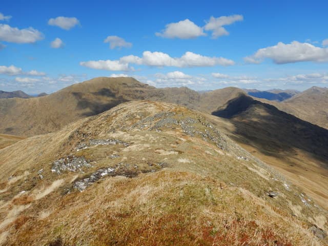
Sgùrr Coire Choinnichean rises directly above the township of Inverie at the heart of Knoydart — one of the few hills in Scotland with no road access of any kind to its base. The 796m summit comes via a steep walk straight from the village (itself reached only by ferry from Mallaig or by foot across the Knoydart hills). The mountain is a fine vantage point over Loch Nevis, Loch Hourn, the Sleat peninsula of Skye, and the long wild rampart of Ladhar Bheinn to the north-west. Often climbed in conjunction with a night at the Old Forge — the most isolated pub in mainland Britain.
Gaelic: “sharp peak, corrie” · Pronunciation: skoor kor-a choinnichean
Quick facts
- Height
- 796m/ 2612ft
- Prominence
- 304 m
- Distance
- 8 km
- Ascent
- 750 m
- Time
- 2–4 hrs
- Grid ref
- NG790010
- Nearest city
- Fort William· 41km
- Dogs
- Dogs on lead required near livestockDog-friendly guide ↗
Height and prominence cross-checked against the Database of British and Irish Hills (CC BY).
No GPX track yet
Walked this route? Share your track to help other walkers.
Standard route
township track 20% · heather hillside 35% · rocky ridge 35% · summit area 10%
From the pier at Inverie, walk south along the village road and turn up the track behind the Knoydart Foundation office heading east-north-east. The route climbs steeply through bracken and woodland onto open hillside, then follows the broad south-west ridge to the summit. The ascent is short and sharp — under 4km each way but with 750m of climbing. Return is the same way. Allow 4–5 hours from Inverie, plus ferry timings from Mallaig.
Terrain
Steep grass and bracken on the lower slopes — slippery in wet, slow in summer growth. Above the bracken line the going is grass and heather with rock outcrops. The upper ridge is broad and grassy; the top itself is a small rocky platform with a modest cairn. No path of note above the lower township track.
In winter
In winter the south-west ridge becomes a steep snow climb in firm conditions. Knoydart's maritime location means snow rarely persists at the modest summit altitude, but when it does the ascent is committing because the only escape is back to Inverie and the ferry. Mallaig–Inverie ferry runs are reduced in winter — check timetables carefully.
Best time of year
Getting there
- Glasgow3h 2m
- Edinburgh4h 43m
Ferry access
Mallaig → Inverie (Knoydart)
- Crossing time45 min
- Summer sailingsMon–Sat, 2–3 sailings daily (Apr–Oct, Western Isles Cruises)
- Winter sailingsMon/Wed/Fri only (Nov–Mar)
- Book ahead3 days
- Last ferry backLast ferry from Inverie ~17:30 (check Western Isles Cruises timetable)
Knoydart is a roadless peninsula — not an island, but accessible only by ferry or a very long walk (18+ km over difficult terrain). Day trips to Sgùrr Coire Choinnichean are achievable in summer. For Ladhar Bheinn, base yourself overnight at Inverie.
Book on ferry operator ↗OS maps: OS Landranger 33
Mobile signal: Patchy at Inverie village; usually none on the upper hill. Knoydart has no road access — there is no driveable parking
Current conditions
Daylight Today
- Sunrise
- 04:47
- Sunset
- 22:10
- Civil dawn
- 03:46
- Civil dusk
- 23:11
NOAA Solar Calculator · 13 July 2026
Around Sgurr Coire Choinnichean on the SCOT network
Getting there, basing yourself, and what to do off the hill.
Sgurr Coire Choinnichean — common questions
- How difficult is Sgurr Coire Choinnichean?
- Sgurr Coire Choinnichean carries a 2/5 (moderate) grade on the OutdoorSCOT scale. Count on about 8km, 750m of ascent and a 2-4 hour day on the standard route. Ground conditions: Steep grass and bracken on the lower slopes — slippery in wet, slow in summer growth.
- How much drop does Sgurr Coire Choinnichean have?
- The drop is 304m: measured from the summit of Sgurr Coire Choinnichean down to the saddle joining it to higher terrain.
- What's the best month to climb Sgurr Coire Choinnichean?
- Aim for May, June, July, August, September on Sgurr Coire Choinnichean. In the remaining months treat it as a winter hill — full kit, solid navigation, and a look at the relevant SAIS avalanche forecast before you go.
- Can dogs go up Sgurr Coire Choinnichean?
- Dogs are fine on a lead. The route passes livestock or ground-nesting bird habitat, so keep them close throughout.
- Will I get phone signal on Sgurr Coire Choinnichean?
- Patchy at Inverie village; usually none on the upper hill. Knoydart has no road access — there is no driveable parking
- How do I get the ferry to Sgurr Coire Choinnichean?
- Mallaig → Inverie (Knoydart). Mon–Sat, 2–3 sailings daily (Apr–Oct, Western Isles Cruises) in summer; Mon/Wed/Fri only (Nov–Mar) in winter. Book at least 3 days ahead. Knoydart is a roadless peninsula — not an island, but accessible only by ferry or a very long walk (18+ km over difficult terrain). Day trips to Sgùrr Coire Choinnichean are achievable in summer. For Ladhar Bheinn, base yourself overnight at Inverie.
- Is Sgurr Coire Choinnichean safe in winter?
- In winter the south-west ridge becomes a steep snow climb in firm conditions. Knoydart's maritime location means snow rarely persists at the modest summit altitude, but when it does the ascent is committing because the only escape is back to Inverie and the ferry. Mallaig–Inverie ferry runs are reduced in winter — check timetables carefully.
Get the OutdoorSCOT weekly
One email a week — new route, hill and bothy guides, seasonal conditions and the odd hard-won lesson. No spam, unsubscribe in one click.