Corbett · Knoydart
Beinn Bhuidhe
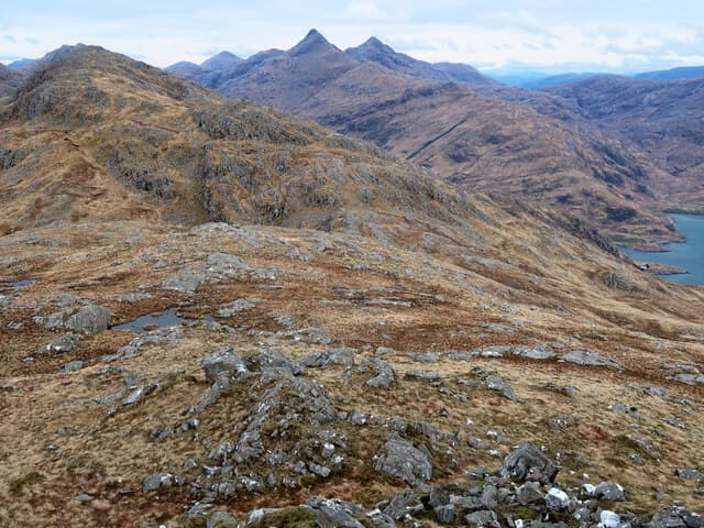
Beinn Bhuidhe of Knoydart — distinct from the Glen Fyne Corbett of the same name — is the 855m hill at the south-east corner of the Knoydart peninsula, rising above Barrisdale on the south side of Loch Hourn. Across the loch lie the larger Knoydart Munros; the rough coastal path from Kinloch Hourn that also serves Ladhar Bheinn is the standard access. The Gaelic name simply means 'the yellow hill', a reference to the autumn moor-grass colour that dominates the slopes.
Quick facts
- Height
- 855.4m/ 2806ft
- Prominence
- 308 m
- Distance
- 18 km
- Ascent
- 1000 m
- Time
- 5–8 hrs
- Grid ref
- NM821967
- Parking
- NG949068
- Nearest city
- Fort William· 36km
- Dogs
- Dogs on lead required near livestockDog-friendly guide ↗
Height and prominence cross-checked against the Database of British and Irish Hills (CC BY).
No GPX track yet
Walked this route? Share your track to help other walkers.
Standard route
glen path 20% · steep grass 45% · rocky upper section 25% · summit area 10%
From the Kinloch Hourn road head (NG949068), follow the coastal path west-south-west around the loch shore for around 5km to Barrisdale Bay. From the bay, climb directly north-east up the steep grassy flank of Beinn Bhuidhe. The summit cairn is reached after a sustained pull on grass and rock. Return reverses the line — or extend along the ridge to Sgùrr nan Eugallt for a long Knoydart-edge day. Allow 7–8 hours.
Terrain
Coastal path on the long approach — rough and undulating, with several streams to cross. Above Barrisdale the slope is steep grass with rocky outcrops; the upper ridge is firmer underfoot. The summit cairn sits on a low rocky outcrop. The descent to Barrisdale is slippery in wet.
In winter
A serious far-west winter day. The Kinloch Hourn road can be closed by snow, the coastal path holds ice in lee aspects, and the steep grass ascent above Barrisdale becomes a real snow climb in firm conditions. No phone signal anywhere on the route. Best as a multi-day with bothy bases at Barrisdale.
Best time of year
Getting there
- Glasgow3h 55m
- Edinburgh4h 37m
OS maps: OS Landranger 33, OS Landranger 40
Mobile signal: No usable signal at Kinloch Hourn or on the route — Knoydart edge is a recognised blackspot. PLB or satellite messenger recommended
Current conditions
Daylight Today
- Sunrise
- 04:53
- Sunset
- 22:04
- Civil dawn
- 03:54
- Civil dusk
- 23:03
NOAA Solar Calculator · 17 July 2026
Around Beinn Bhuidhe on the SCOT network
Getting there, basing yourself, and what to do off the hill.
Beinn Bhuidhe — common questions
- How difficult is Beinn Bhuidhe?
- Beinn Bhuidhe carries a 3/5 (moderately challenging) grade on the OutdoorSCOT scale. Count on about 18km, 1000m of ascent and a 5-8 hour day on the standard route. Terrain: Coastal path on the long approach — rough and undulating, with several streams to cross.
- How prominent is Beinn Bhuidhe?
- Beinn Bhuidhe has 308m of topographic prominence — the height of its summit above the highest col connecting it to higher ground.
- Where should I park to climb Beinn Bhuidhe?
- Standard parking is at NG949068. Check the parking grid reference on an OS map before travel; informal laybys can fill on summer weekends.
- When should I climb Beinn Bhuidhe?
- The standard good-weather months for Beinn Bhuidhe are May, June, July, August, September. Outside those months, expect winter conditions on the high ground — full mountain kit, navigation skills, and a check of the SAIS avalanche forecast for the relevant region.
- Can I bring my dog up Beinn Bhuidhe?
- On a lead only — the route crosses ground with livestock or nesting-bird interest.
- What's mobile reception like on Beinn Bhuidhe?
- No usable signal at Kinloch Hourn or on the route — Knoydart edge is a recognised blackspot. PLB or satellite messenger recommended
- Is Beinn Bhuidhe safe in winter?
- A serious far-west winter day. The Kinloch Hourn road can be closed by snow, the coastal path holds ice in lee aspects, and the steep grass ascent above Barrisdale becomes a real snow climb in firm conditions. No phone signal anywhere on the route. Best as a multi-day with bothy bases at Barrisdale.
Get the OutdoorSCOT weekly
One email a week — new route, hill and bothy guides, seasonal conditions and the odd hard-won lesson. No spam, unsubscribe in one click.