Munro · Cairngorms
Beinn a' Ghlo - Carn nan Gabhar
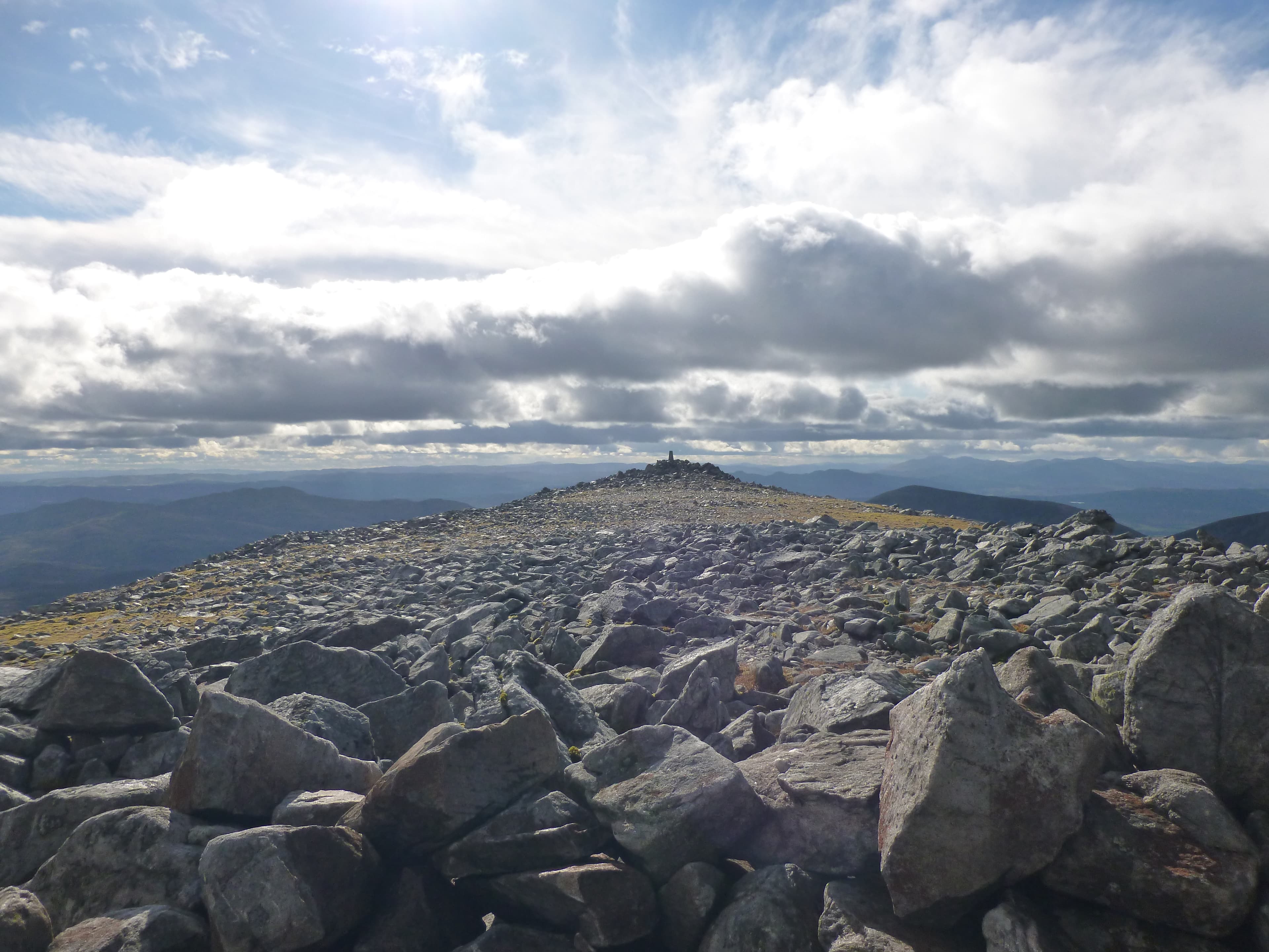
Beinn a' Ghlo — "hill of the mist" — is the great rolling mountain massif east of Blair Atholl, the dominant skyline feature from the A9 corridor through Perthshire. Carn nan Gabhar is the highest of its three Munros at 1121m, the eastern peak of a 4km horseshoe that includes Bràigh Coire Chruinn-bhalgain and Carn Liath. The hill is famous for its endless rolling summit ridges and broad heathery flanks; Queen Victoria called it her favourite Highland mountain.
Gaelic: “mountain, of the, cairn-topped hill, of the, goat” · Pronunciation: bine uh ghlo karn nan gabhar
Quick facts
- Height
- 1121.9m/ 3681ft
- Prominence
- 658 m
- Distance
- 18 km
- Ascent
- 987 m
- Time
- 6–9 hrs
- Grid ref
- NN971733
- Parking
- NN905671
- Nearest city
- Perth· 52km
- Dogs
- Dogs on lead required near livestockDog-friendly guide ↗
Height and prominence cross-checked against the Database of British and Irish Hills (CC BY).
No GPX track yet
Walked this route? Share your track to help other walkers.
Standard route
Forest / moorland path 35% · Mountain path 35% · Plateau / boulder field 30%
The classic Beinn a' Ghlo round starts from Loch Moraig east of Blair Atholl, climbing Carn Liath first via the prominent south ridge, then traversing the broad horseshoe over Bràigh Coire Chruinn-bhalgain and on to Carn nan Gabhar at the far east end. Around 22km with 1400m of cumulative ascent for the three Munros. Carn nan Gabhar alone via the same start is 18km return with 987m of ascent.
Terrain
The Loch Moraig and Glen Tilt approach tracks are firm gravel. The ridges of Beinn a' Ghlo are broad heather and short turf with intermittent path — easy walking but pathless in places between tops. The summit area of Carn nan Gabhar is a stony plateau with the large cairn at the high point. No exposure on the standard line; navigation across the broad ridges in mist demands compass work.
In winter
A friendly winter Munro round with no avalanche slopes of consequence and broad ridge walking. The cornicing on the north-east edges above Glen Tilt is moderate. The summit plateau picks up easterly snowfall and can be a navigation challenge in whiteout. The Loch Moraig road is gritted by the estate. SAIS Southern Cairngorms covers the area.
This hill is in the Northern Cairngorms SAIS forecast area. Check SAIS forecasts in winter (December–April).
Best time of year
Getting there
- Glasgow2h 26m
- Edinburgh2h 12m
OS maps: OS Landranger 43
Mobile signal: Signal can't be trusted above the treeline. The Loch Moraig and Glen Tilt car parks have very patchy coverage. Càrn nan Gabhar demands offline maps and independent navigation.
Current conditions
Daylight Today
- Sunrise
- 04:57
- Sunset
- 21:46
- Civil dawn
- 04:02
- Civil dusk
- 22:40
NOAA Solar Calculator · 23 July 2026
Around Beinn a' Ghlo - Carn nan Gabhar on the SCOT network
Getting there, basing yourself, and what to do off the hill.
Getting there: Blair Atholl station
Beinn a Ghlo; Glen Tilt corridor north to the Cairngorms
13km from the hill
tripscot.co.uk
On TripSCOTBase yourself in Pitlochry
Perthshire base — Schiehallion, Beinn a Ghlo, Ben Vrackie
15km from the hill
tripscot.co.uk
On TasteSCOTAfter the hill: Edradour
Pitlochry — until recently Scotland's smallest distillery; charming Perthshire setting
14km from the hill
tastescot.co.uk
Beinn a' Ghlo - Carn nan Gabhar — common questions
- How difficult is Beinn a' Ghlo - Carn nan Gabhar?
- Beinn a' Ghlo - Carn nan Gabhar carries a 3/5 (moderately challenging) grade on the OutdoorSCOT scale. Count on about 18km, 987m of ascent and a 6-9 hour day on the standard route. Terrain: The Loch Moraig and Glen Tilt approach tracks are firm gravel.
- How prominent is Beinn a' Ghlo - Carn nan Gabhar?
- Beinn a' Ghlo - Carn nan Gabhar has 658m of topographic prominence — the height of its summit above the highest col connecting it to higher ground.
- Where should I park to climb Beinn a' Ghlo - Carn nan Gabhar?
- Standard parking is at NN905671. Check the parking grid reference on an OS map before travel; informal laybys can fill on summer weekends.
- When should I climb Beinn a' Ghlo - Carn nan Gabhar?
- The standard good-weather months for Beinn a' Ghlo - Carn nan Gabhar are May, June, July, August, September, October. Outside those months, expect winter conditions on the high ground — full mountain kit, navigation skills, and a check of the SAIS avalanche forecast for the relevant region.
- Can I bring my dog up Beinn a' Ghlo - Carn nan Gabhar?
- On a lead only — the route crosses ground with livestock or nesting-bird interest.
- What's mobile reception like on Beinn a' Ghlo - Carn nan Gabhar?
- Signal can't be trusted above the treeline. The Loch Moraig and Glen Tilt car parks have very patchy coverage. Càrn nan Gabhar demands offline maps and independent navigation.
- Is Beinn a' Ghlo - Carn nan Gabhar safe in winter?
- A friendly winter Munro round with no avalanche slopes of consequence and broad ridge walking. The cornicing on the north-east edges above Glen Tilt is moderate. The summit plateau picks up easterly snowfall and can be a navigation challenge in whiteout. The Loch Moraig road is gritted by the estate. SAIS Southern Cairngorms covers the area.
Get the OutdoorSCOT weekly
One email a week — new route, hill and bothy guides, seasonal conditions and the odd hard-won lesson. No spam, unsubscribe in one click.