Corbett · Cairngorms
Ben Vuirich
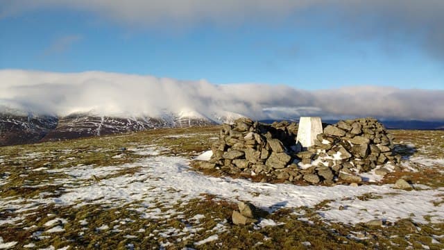
Ben Vuirich is the rounded 903m Corbett standing alone above Glen Loch in Atholl, north-east of Blair Atholl. The mountain has the lived-in character of an estate hill — peat hag, deer fence, distant stalking shelters — and gives a fine vantage on the great rampart of Beinn a' Ghlò to the south-west. North of the summit the moor rolls away toward the Cairngorm plateau in an empty sweep. Bike-and-walk is the standard tactic for the long approach up Glen Loch.
Quick facts
- Height
- 903.1m/ 2963ft
- Prominence
- 346 m
- Distance
- 22 km
- Ascent
- 770 m
- Time
- 5–8 hrs
- Grid ref
- NN997700
- Parking
- NN876662
- Nearest city
- Perth· 48km
- Dogs
- Dogs on lead required near livestockDog-friendly guide ↗
Height and prominence cross-checked against the Database of British and Irish Hills (CC BY).
No GPX track yet
Walked this route? Share your track to help other walkers.
Standard route
forest track 20% · stalkers path 45% · heather ridge 25% · summit area 10%
Start from the same Atholl trailhead at Old Bridge of Tilt (NN876662). Take the estate road that runs east of Glen Tilt, gaining height through farmland before turning into the wider Glen Loch system. The route loops round the head of the loch, then turns up the south-west flank of the hill — a broad grassy face leading to the rounded summit. Most parties also tag Beinn Mheadhonach to the west for the Atholl Corbett pair. Plan on 7–8 hours on foot from the bridge, or shave a couple by riding the lower track.
Terrain
An excellent estate road covers the lower miles — wide, dry and bike-friendly. From the track end it is open heather and peat with only a faint trail. The summit crest is a wide grassy whale-back; a pointed stone marks the cairn. Tilt-system rain shadow keeps the ground noticeably drier than west-coast Corbetts.
In winter
Snow gathers heavily on the lee aspect through midwinter and the broad top hangs onto cover well into March. Once temperatures fall the upper miles of the Glen Tilt track freeze hard even when the southern reach has been gritted. A friendly winter ascent for parties prepared to start in the dark — no avalanche issues on the standard ascent route.
This hill is in the Northern Cairngorms SAIS forecast area. Check SAIS forecasts in winter (December–April).
Best time of year
Getting there
- Glasgow2h 23m
- Edinburgh2h 7m
OS maps: OS Landranger 43
Mobile signal: EE/Vodafone usable at Old Bridge of Tilt; signal weakens in Glen Loch; brief signal returning on the summit when you can see Pitlochry
Current conditions
Daylight Today
- Sunrise
- 04:41
- Sunset
- 22:00
- Civil dawn
- 03:40
- Civil dusk
- 23:00
NOAA Solar Calculator · 13 July 2026
Around Ben Vuirich on the SCOT network
Getting there, basing yourself, and what to do off the hill.
Getting there: Pitlochry station
Schiehallion, Ben Vrackie, Beinn a Ghlo, Edradour distillery
13km from the hill
tripscot.co.uk
On TripSCOTBase yourself in Pitlochry
Perthshire base — Schiehallion, Beinn a Ghlo, Ben Vrackie
13km from the hill
tripscot.co.uk
On TasteSCOTAfter the hill: Edradour
Pitlochry — until recently Scotland's smallest distillery; charming Perthshire setting
11km from the hill
tastescot.co.uk
Ben Vuirich — common questions
- How difficult is Ben Vuirich?
- Ben Vuirich carries a 2/5 (moderate) grade on the OutdoorSCOT scale. Count on about 22km, 770m of ascent and a 5-8 hour day on the standard route. Ground conditions: An excellent estate road covers the lower miles — wide, dry and bike-friendly.
- How much drop does Ben Vuirich have?
- The drop is 346m: measured from the summit of Ben Vuirich down to the saddle joining it to higher terrain.
- Where's the parking for Ben Vuirich?
- Park at NN876662. Double-check the grid reference on an OS map first; informal laybys here fill early in high season.
- What's the best month to climb Ben Vuirich?
- Aim for May, June, July, August, September, October on Ben Vuirich. In the remaining months treat it as a winter hill — full kit, solid navigation, and a look at the relevant SAIS avalanche forecast before you go.
- Can dogs go up Ben Vuirich?
- Dogs are fine on a lead. The route passes livestock or ground-nesting bird habitat, so keep them close throughout.
- Will I get phone signal on Ben Vuirich?
- EE/Vodafone usable at Old Bridge of Tilt; signal weakens in Glen Loch; brief signal returning on the summit when you can see Pitlochry
- Is Ben Vuirich safe in winter?
- Snow gathers heavily on the lee aspect through midwinter and the broad top hangs onto cover well into March. Once temperatures fall the upper miles of the Glen Tilt track freeze hard even when the southern reach has been gritted. A friendly winter ascent for parties prepared to start in the dark — no avalanche issues on the standard ascent route.
Get the OutdoorSCOT weekly
One email a week — new route, hill and bothy guides, seasonal conditions and the odd hard-won lesson. No spam, unsubscribe in one click.