Corbett · Cairngorms
Beinn Mheadhonach
Beinn Mheadhonach — 'the middle hill' — is the 900m Atholl Corbett standing immediately west of Ben Vuirich, the natural pairing for a long Glen Tilt day. The mountain is named for its position between Glen Tilt to the south and Glen Bruar to the north, and its broad whaleback summit gives one of the cleanest views of the great Beinn a' Ghlò ridge to the south-west. Most parties combine it with Ben Vuirich on the same bike-in from Old Bridge of Tilt, making a satisfying Atholl Corbett double from a single Blair Atholl base.
Quick facts
- Height
- 900.9m/ 2956ft
- Prominence
- 165 m
- Distance
- 20 km
- Ascent
- 780 m
- Time
- 4–7 hrs
- Grid ref
- NN880758
- Parking
- NN876662
- Nearest city
- Perth· 57km
- Dogs
- Dogs on lead required near livestockDog-friendly guide ↗
Height and prominence cross-checked against the Database of British and Irish Hills (CC BY).
No GPX track yet
Walked this route? Share your track to help other walkers.
Standard route
estate road 30% · rough grass 40% · heather moorland 20% · grassy summit 10%
Start at Old Bridge of Tilt (NN876662). Cycle or walk the Glen Tilt estate road for around 7km to Marble Lodge, then take the path north-east up the slopes of Beinn Mheadhonach. Open hillside leads to a long broad ridge running roughly north-south; the summit cairn sits midway along it. For the natural double, continue east across the moor and re-climb Ben Vuirich. Allow 7–8 hours for Beinn Mheadhonach alone, faster with a bike.
Terrain
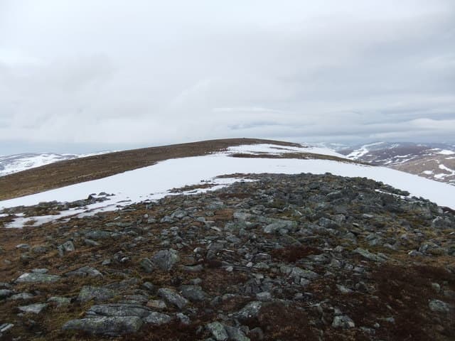
Excellent estate road for the Glen Tilt approach. Above Marble Lodge the going is heather and grass on a sustained but gentle gradient, with no rocky difficulties. The summit ridge is wide and flat-topped; the cairn is small and sits on an embedded rock near the middle of the ridge — easy to miss in cloud.
In winter
Snow lies long on the upper Atholl plateau through January and February. The broad summit ridge needs careful navigation in poor visibility — featureless ground with the cairn well off the obvious line of travel. No avalanche concerns on the standard ascent. The lower Glen Tilt track can hold ice but is generally driveable to the public road end.
This hill is in the Northern Cairngorms SAIS forecast area. Check SAIS forecasts in winter (December–April).
Best time of year
Getting there
- Glasgow2h 26m
- Edinburgh2h 19m
OS maps: OS Landranger 43
Mobile signal: Poor to no signal in this remote Atholl glen
Current conditions
Daylight Today
- Sunrise
- 04:41
- Sunset
- 22:01
- Civil dawn
- 03:41
- Civil dusk
- 23:02
NOAA Solar Calculator · 13 July 2026
Pair with
Curated multi-hill combinations from Beinn Mheadhonach.
Around Beinn Mheadhonach on the SCOT network
Getting there, basing yourself, and what to do off the hill.
Getting there: Blair Atholl station
Beinn a Ghlo; Glen Tilt corridor north to the Cairngorms
11km from the hill
tripscot.co.uk
On TripSCOTBase yourself in Pitlochry
Perthshire base — Schiehallion, Beinn a Ghlo, Ben Vrackie
18km from the hill
tripscot.co.uk
On TasteSCOTAfter the hill: Blair Athol
Pitlochry — main town distillery and home of Bell's blends
19km from the hill
tastescot.co.uk
Beinn Mheadhonach — common questions
- Is Beinn Mheadhonach a hard climb?
- Beinn Mheadhonach is rated 2/5 (moderate) on the OutdoorSCOT scale. The standard route covers about 20km with 780m of ascent and takes most walkers 4-7 hours. Underfoot: Excellent estate road for the Glen Tilt approach.
- What is Beinn Mheadhonach's prominence?
- 165m of prominence. That's the vertical drop from the summit to the col that links Beinn Mheadhonach to the next higher ground.
- Where do I park for Beinn Mheadhonach?
- Most walkers start from NN876662. Verify the grid reference on an OS map before you set off — space is tight on busy summer weekends.
- When is the best time to climb Beinn Mheadhonach?
- May, June, July, August, September, October give the most reliable conditions on Beinn Mheadhonach. Beyond that window the high ground turns wintry: carry full mountain kit, be confident navigating, and check the SAIS avalanche forecast for the area.
- Is Beinn Mheadhonach dog-friendly?
- Yes, but dogs must be kept on a lead — there is livestock or ground-nesting bird interest on the route.
- Is there mobile signal on Beinn Mheadhonach?
- Poor to no signal in this remote Atholl glen
- Is Beinn Mheadhonach safe in winter?
- Snow lies long on the upper Atholl plateau through January and February. The broad summit ridge needs careful navigation in poor visibility — featureless ground with the cairn well off the obvious line of travel. No avalanche concerns on the standard ascent. The lower Glen Tilt track can hold ice but is generally driveable to the public road end.
Get the OutdoorSCOT weekly
One email a week — new route, hill and bothy guides, seasonal conditions and the odd hard-won lesson. No spam, unsubscribe in one click.