Corbett · Cairngorms
Beinn Bhreac
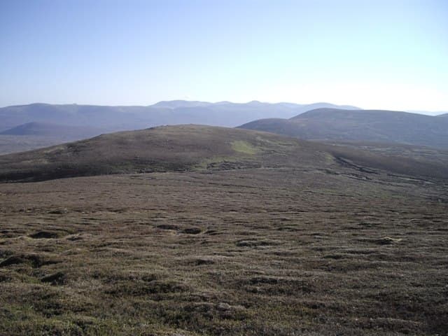
Beinn Bhreac — 'the speckled hill' — is the broad heather Corbett rising north of Glen Tilt above the head of Glen Bruar in Atholl. The 912m summit sits at the eastern edge of the great Cairngorm plateau system and gives a wide-angle view across to Beinn a' Ghlò to the south and the wild Tarf country to the north. Most parties bag it as a long bike-and-walk from Glen Tilt or as part of a multi-day Cairngorm crossing. The hill is quiet, remote, and characteristic of the eastern Cairngorm outliers — high but rounded, with a sense of empty space.
Quick facts
- Height
- 912.44m/ 2994ft
- Prominence
- 171 m
- Distance
- 30 km
- Ascent
- 800 m
- Time
- 7–11 hrs
- Grid ref
- NN868820
- Parking
- NN876662
- Nearest
- Perth· Inverness 66km
- Dogs
- Dogs on lead required near livestockDog-friendly guide ↗
Height and prominence cross-checked against the Database of British and Irish Hills (CC BY).
No GPX track yet
Walked this route? Share your track to help other walkers.
Standard route
peat moorland 50% · heather 30% · grass and moss 15% · summit plateau 5%
The standard approach is from Old Bridge of Tilt near Blair Atholl (NN876662). Take the estate track north up Glen Tilt — best ridden — for around 12km to Forest Lodge, then continue another 4km up Tarf Water. Leave the track and climb west onto Beinn Bhreac's broad south ridge, gaining the summit after a steady pull. Allow 9–11 hours on foot, 5–7 with a bike on the inward miles.
Terrain
Excellent estate track for the long approach — Glen Tilt is one of the great walking-and-cycling routes in the eastern Highlands. Above the track the going is heather, grass and peat hag with no path of consequence. The summit plateau is wide and shallow-domed; a small cairn marks the high point on a low outcrop.
In winter
A long winter day. The southern part of Glen Tilt sometimes sees the track plough but the upper miles hold deep drifts. Once the surface ices up, the bike becomes a liability rather than a help. Snow lies long on the summit plateau; cornices form on the north side. Best as a two-day trip with a bivouac or bothy base, given midwinter daylight constraints.
This hill is in the Northern Cairngorms SAIS forecast area. Check SAIS forecasts in winter (December–April).
Best time of year
Getting there
- Glasgow3h 33m
- Edinburgh2h 26m
OS maps: OS Landranger 43
Mobile signal: Reasonable EE/Vodafone at Old Bridge of Tilt; signal weakens through Glen Tilt; no signal on the summit or in the upper Tarf country
Current conditions
Daylight Today
- Sunrise
- 04:41
- Sunset
- 22:02
- Civil dawn
- 03:40
- Civil dusk
- 23:02
NOAA Solar Calculator · 13 July 2026
Around Beinn Bhreac on the SCOT network
Getting there, basing yourself, and what to do off the hill.
Getting there: Blair Atholl station
Beinn a Ghlo; Glen Tilt corridor north to the Cairngorms
17km from the hill
tripscot.co.uk
On TripSCOTBase yourself in Pitlochry
Perthshire base — Schiehallion, Beinn a Ghlo, Ben Vrackie
24km from the hill
tripscot.co.uk
On TasteSCOTAfter the hill: Dalwhinnie
Dalwhinnie — Scotland's highest distillery on the Drumochter pass
24km from the hill
tastescot.co.uk
Beinn Bhreac — common questions
- What difficulty is Beinn Bhreac?
- On the OutdoorSCOT scale, Beinn Bhreac comes in at 3/5 — moderately challenging. Expect roughly 30km and 800m of ascent on the usual route — 7-11 hours for most parties. Terrain: Excellent estate track for the long approach — Glen Tilt is one of the great walking-and-cycling routes in the eastern Highlands.
- How prominent is Beinn Bhreac?
- Beinn Bhreac has 171m of topographic prominence — the height of its summit above the highest col connecting it to higher ground.
- Where should I park to climb Beinn Bhreac?
- Standard parking is at NN876662 near Perth. Check the parking grid reference on an OS map before travel; informal laybys can fill on summer weekends.
- When should I climb Beinn Bhreac?
- The standard good-weather months for Beinn Bhreac are May, June, July, August, September, October. Outside those months, expect winter conditions on the high ground — full mountain kit, navigation skills, and a check of the SAIS avalanche forecast for the relevant region.
- Can I bring my dog up Beinn Bhreac?
- On a lead only — the route crosses ground with livestock or nesting-bird interest.
- What's mobile reception like on Beinn Bhreac?
- Reasonable EE/Vodafone at Old Bridge of Tilt; signal weakens through Glen Tilt; no signal on the summit or in the upper Tarf country
- Is Beinn Bhreac safe in winter?
- A long winter day. The southern part of Glen Tilt sometimes sees the track plough but the upper miles hold deep drifts. Once the surface ices up, the bike becomes a liability rather than a help. Snow lies long on the summit plateau; cornices form on the north side. Best as a two-day trip with a bivouac or bothy base, given midwinter daylight constraints.
Get the OutdoorSCOT weekly
One email a week — new route, hill and bothy guides, seasonal conditions and the odd hard-won lesson. No spam, unsubscribe in one click.