Munro · Cairngorms
Carn an Righ
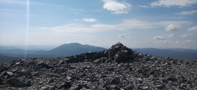
Càrn an Rìgh (1029m) — "the king's cairn" — is a broad, remote Munro standing on the high ground between Glas Tulaichean to the south-east and Beinn Iutharn Mhòr to the east. The hill is rarely climbed in isolation and is almost always paired with Glas Tulaichean or included in a longer round of Beinn Iutharn Mhòr too. The summit cairn has a small stone shelter perched at the top, welcome on the often-windy plateau.
Quick facts
- Height
- 1029m/ 3376ft
- Prominence
- 258 m
- Distance
- 17 km
- Ascent
- 906 m
- Time
- 5–8 hrs
- Grid ref
- NO028772
- Parking
- NO091713
- Nearest city
- Perth· 54km
- Dogs
- Dogs on lead required near livestockDog-friendly guide ↗
Height and prominence cross-checked against the Database of British and Irish Hills (CC BY).
No GPX track yet
Walked this route? Share your track to help other walkers.
Standard route
Stalkers path 40% · Open moorland 40% · Summit plateau 20%
From the Dalmunzie Hotel near Spittal of Glenshee, take the private estate landrover track north-west up Gleann Taitneach almost to the summit of Glas Tulaichean. From there drop north-west into the broad bealach (Mam nan Carn), then climb the long broad south-east shoulder of Càrn an Rìgh. Most parties return over Glas Tulaichean for both Munros. Around 18km with 950m of ascent for the pair.
Terrain
The Dalmunzie estate track is excellent surface for fast access to the higher ground. Once off the track the surface turns to rough heathery hillside, with peat hags in the Mam nan Carn bealach itself. The summit dome of Càrn an Rìgh is broad mossy turf and gravel with a stone shelter at the cairn. Navigation across the broad linking bealach in poor visibility is the main challenge of the round.
In winter
A remote winter Munro day. The Mam nan Carn bealach fills with deep wind-blown snow — slow and tiring under foot. The broad summit dome drifts heavily and offers few navigation landmarks. Phone signal is absent throughout. Dalmunzie estate access can be drifted closed; the A93 to Spittal of Glenshee is gritted but the side road is private. SAIS Southern Cairngorms applies.
This hill is in the Northern Cairngorms SAIS forecast area. Check SAIS forecasts in winter (December–April).
Best time of year
Getting there
- Glasgow3h 33m
- Edinburgh2h 15m
OS maps: OS Landranger 43
Mobile signal: Signal gone above 750m on the remote Glenshee plateau. Spittal of Glenshee has intermittent coverage. Preload mapping before the walk-in.
Current conditions
Daylight Today
- Sunrise
- 04:56
- Sunset
- 21:45
- Civil dawn
- 04:01
- Civil dusk
- 22:40
NOAA Solar Calculator · 23 July 2026
Pair with
Curated multi-hill combinations from Carn an Righ.
Around Carn an Righ on the SCOT network
Getting there, basing yourself, and what to do off the hill.
Getting there: Blair Atholl station
Beinn a Ghlo; Glen Tilt corridor north to the Cairngorms
20km from the hill
tripscot.co.uk
On TripSCOTBase yourself in Pitlochry
Perthshire base — Schiehallion, Beinn a Ghlo, Ben Vrackie
21km from the hill
tripscot.co.uk
On TasteSCOTAfter the hill: Edradour
Pitlochry — until recently Scotland's smallest distillery; charming Perthshire setting
19km from the hill
tastescot.co.uk
Carn an Righ — common questions
- How hard is Carn an Righ?
- We grade Carn an Righ at 4/5, which puts it in challenging territory. The usual route is around 17km with 906m of climbing; allow 5-8 hours. Underfoot: The Dalmunzie estate track is excellent surface for fast access to the higher ground.
- What is Carn an Righ's prominence?
- 258m of prominence. That's the vertical drop from the summit to the col that links Carn an Righ to the next higher ground.
- Where do I park for Carn an Righ?
- Most walkers start from NO091713. Verify the grid reference on an OS map before you set off — space is tight on busy summer weekends.
- When is the best time to climb Carn an Righ?
- May, June, July, August, September, October give the most reliable conditions on Carn an Righ. Beyond that window the high ground turns wintry: carry full mountain kit, be confident navigating, and check the SAIS avalanche forecast for the area.
- Is Carn an Righ dog-friendly?
- Yes, but dogs must be kept on a lead — there is livestock or ground-nesting bird interest on the route.
- Is there mobile signal on Carn an Righ?
- Signal gone above 750m on the remote Glenshee plateau. Spittal of Glenshee has intermittent coverage. Preload mapping before the walk-in.
- Is Carn an Righ safe in winter?
- A remote winter Munro day. The Mam nan Carn bealach fills with deep wind-blown snow — slow and tiring under foot. The broad summit dome drifts heavily and offers few navigation landmarks. Phone signal is absent throughout. Dalmunzie estate access can be drifted closed; the A93 to Spittal of Glenshee is gritted but the side road is private. SAIS Southern Cairngorms applies.
Get the OutdoorSCOT weekly
One email a week — new route, hill and bothy guides, seasonal conditions and the odd hard-won lesson. No spam, unsubscribe in one click.