Munro · Cairngorms
Glas Tulaichean
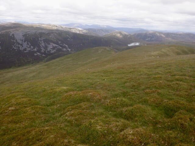
Glas Tulaichean (1051m) is a broad, rounded Munro at the head of Gleann Taitneach above the Spittal of Glenshee. It sits south of the main Cairnwell Munros, on the watershed between the south-flowing Tay and the east-flowing Isla. Usually paired with Càrn an Righ in a long round, or climbed alone via the excellent Dalmunzie stalkers' track — one of the longer and easier approaches to a high Munro. Quiet by Glenshee standards.
Gaelic: “grey-green” · Pronunciation: glass tulaichean
Quick facts
- Height
- 1051m/ 3448ft
- Prominence
- 384 m
- Distance
- 18 km
- Ascent
- 925 m
- Time
- 6–9 hrs
- Grid ref
- NO051760
- Parking
- NO091713
- Nearest city
- Perth· 53km
- Dogs
- Dogs on lead required near livestockDog-friendly guide ↗
Height and prominence cross-checked against the Database of British and Irish Hills (CC BY).
No GPX track yet
Walked this route? Share your track to help other walkers.
Standard route
Stalkers path 45% · Open hillside 35% · Summit plateau 20%
Start from the Dalmunzie Hotel near the Spittal of Glenshee (small charge for parking) and walk up the private estate track that climbs gently north-north-west up Gleann Taitneach. The track curves west onto the south ridge of Glas Tulaichean and ends near the summit — one of the highest landrover tracks in Scotland. From the summit trig pillar most parties extend west to Càrn an Righ. Around 18km with 950m of ascent for the pair; Glas Tulaichean alone is 14km with 740m up.
Terrain
The Dalmunzie estate landrover track is firm and well-graded throughout — an unusually good approach for a remote Munro. The track climbs to almost 1000m on the south ridge. The summit itself is a small flat area with a trig pillar. The descent to the bealach for Càrn an Righ is pathless rough heather. The west flank drops abruptly into Glen Lochsie — keep clear of the edge in mist.
In winter
A reasonably benign winter Munro by Cairngorm standards thanks to the track approach, but the high open plateau is fully exposed to easterly continental winds. Cornicing on the west rim above Glen Lochsie is consistent through the season. The Dalmunzie track itself can be drifted closed. The A93 corridor is gritted but the side road to Dalmunzie is private. SAIS Southern Cairngorms applies.
This hill is in the Northern Cairngorms SAIS forecast area. Check SAIS forecasts in winter (December–April).
Best time of year
Getting there
- Glasgow3h 33m
- Edinburgh2h 13m
OS maps: OS Landranger 43
Mobile signal: Intermittent signal from Spittal of Glenshee car park. Above 800m signal is generally absent. Get maps saved before leaving Blairgowrie.
Current conditions
Daylight Today
- Sunrise
- 04:56
- Sunset
- 21:45
- Civil dawn
- 04:01
- Civil dusk
- 22:40
NOAA Solar Calculator · 23 July 2026
Pair with
Curated multi-hill combinations from Glas Tulaichean.
Around Glas Tulaichean on the SCOT network
Getting there, basing yourself, and what to do off the hill.
Getting there: Pitlochry station
Schiehallion, Ben Vrackie, Beinn a Ghlo, Edradour distillery
20km from the hill
tripscot.co.uk
On TripSCOTBase yourself in Pitlochry
Perthshire base — Schiehallion, Beinn a Ghlo, Ben Vrackie
20km from the hill
tripscot.co.uk
On TasteSCOTAfter the hill: Edradour
Pitlochry — until recently Scotland's smallest distillery; charming Perthshire setting
19km from the hill
tastescot.co.uk
Glas Tulaichean — common questions
- How difficult is Glas Tulaichean?
- Glas Tulaichean carries a 4/5 (challenging) grade on the OutdoorSCOT scale. Count on about 18km, 925m of ascent and a 6-9 hour day on the standard route. Ground conditions: The Dalmunzie estate landrover track is firm and well-graded throughout — an unusually good approach for a remote Munro.
- How much drop does Glas Tulaichean have?
- The drop is 384m: measured from the summit of Glas Tulaichean down to the saddle joining it to higher terrain.
- Where's the parking for Glas Tulaichean?
- Park at NO091713. Double-check the grid reference on an OS map first; informal laybys here fill early in high season.
- What's the best month to climb Glas Tulaichean?
- Aim for May, June, July, August, September, October on Glas Tulaichean. In the remaining months treat it as a winter hill — full kit, solid navigation, and a look at the relevant SAIS avalanche forecast before you go.
- Can dogs go up Glas Tulaichean?
- Dogs are fine on a lead. The route passes livestock or ground-nesting bird habitat, so keep them close throughout.
- Will I get phone signal on Glas Tulaichean?
- Intermittent signal from Spittal of Glenshee car park. Above 800m signal is generally absent. Get maps saved before leaving Blairgowrie.
- Is Glas Tulaichean safe in winter?
- A reasonably benign winter Munro by Cairngorm standards thanks to the track approach, but the high open plateau is fully exposed to easterly continental winds. Cornicing on the west rim above Glen Lochsie is consistent through the season. The Dalmunzie track itself can be drifted closed. The A93 corridor is gritted but the side road to Dalmunzie is private. SAIS Southern Cairngorms applies.
Get the OutdoorSCOT weekly
One email a week — new route, hill and bothy guides, seasonal conditions and the odd hard-won lesson. No spam, unsubscribe in one click.