Munro · Cairngorms
Beinn Iutharn Mhor
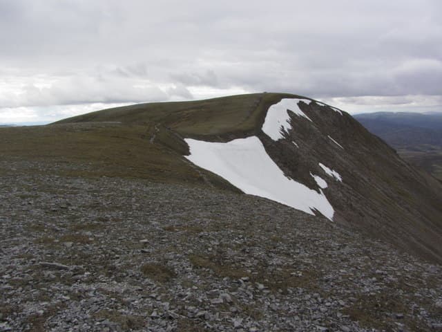
Beinn Iutharn Mhòr (1045m) — "great hill of the edge" — is a broad, remote Munro on the watershed between Glen Ey and Glen Lochsie, deep in the Atholl deer forest country south of Braemar. Together with Càrn Bhac, An Socach (Glenshee) and Càrn an Righ it forms a long round of four somewhat featureless Mounth Munros. The hill is rarely climbed in isolation and the standard approach is a long bike-in from either Glen Ey to the north or Dalmunzie to the south.
Gaelic: “mountain, big” · Pronunciation: bine iutharn vore
Quick facts
- Height
- 1045m/ 3428ft
- Prominence
- 247 m
- Distance
- 18 km
- Ascent
- 920 m
- Time
- 6–9 hrs
- Grid ref
- NO045792
- Parking
- NO091713
- Nearest city
- Perth· 56km
- Dogs
- Dogs on lead required near livestockDog-friendly guide ↗
Height and prominence cross-checked against the Database of British and Irish Hills (CC BY).
No GPX track yet
Walked this route? Share your track to help other walkers.
Standard route
Forest / moorland path 35% · Mountain path 35% · Plateau / boulder field 30%
The Dalmunzie approach offers the most economic single-Munro day. From the Dalmunzie Hotel near Spittal of Glenshee, walk up the estate track north-west to Glas Tulaichean's south ridge, then divert north-east across the broad bealach to climb the south-east shoulder of Beinn Iutharn Mhòr. Most parties combine it with Càrn an Righ. Around 25km with 1100m of ascent for the pair; alternatively a bike-in from Inverey via the Glen Ey track and Altanour Lodge gives a slightly shorter walking distance.
Terrain
The Dalmunzie estate landrover track gives excellent fast going on the approach. Off the track the surface becomes rough heathery moor and the broader bealachs carry heavy peat hag. The south-east shoulder of Iutharn Mhòr is broad mossy turf and gravel. The summit is a small cairn on a wide flat top with few landmarks for navigation. The descent to the bealach for Càrn an Righ crosses peat hags — slow under foot, very slow under snow.
In winter
A remote winter Munro with serious commitment. The long approach in shortened daylight is the main consideration. The broad summit and bealachs drift deeply and the lack of features makes whiteout navigation a real challenge. Phone signal is absent throughout. Dalmunzie track can be drifted closed and the A93 itself sometimes shuts. SAIS Southern Cairngorms applies. Best done on a clear settled day in March/April.
This hill is in the Northern Cairngorms SAIS forecast area. Check SAIS forecasts in winter (December–April).
Best time of year
Getting there
- Glasgow3h 36m
- Edinburgh2h 17m
OS maps: OS Landranger 43
Mobile signal: No steady signal above the trees. The nearest car parks have limited signal (Linn of Dee, Braemar, Cairngorm ski area). Beinn Iutharn Mhor requires offline maps and independent navigation.
Current conditions
Daylight Today
- Sunrise
- 04:56
- Sunset
- 21:45
- Civil dawn
- 04:01
- Civil dusk
- 22:41
NOAA Solar Calculator · 23 July 2026
Around Beinn Iutharn Mhor on the SCOT network
Getting there, basing yourself, and what to do off the hill.
Getting there: Blair Atholl station
Beinn a Ghlo; Glen Tilt corridor north to the Cairngorms
22km from the hill
tripscot.co.uk
On TripSCOTBase yourself in Pitlochry
Perthshire base — Schiehallion, Beinn a Ghlo, Ben Vrackie
23km from the hill
tripscot.co.uk
On TasteSCOTAfter the hill: Edradour
Pitlochry — until recently Scotland's smallest distillery; charming Perthshire setting
22km from the hill
tastescot.co.uk
Beinn Iutharn Mhor — common questions
- How hard is Beinn Iutharn Mhor?
- We grade Beinn Iutharn Mhor at 4/5, which puts it in challenging territory. The usual route is around 18km with 920m of climbing; allow 6-9 hours. Underfoot: The Dalmunzie estate landrover track gives excellent fast going on the approach.
- What is Beinn Iutharn Mhor's prominence?
- 247m of prominence. That's the vertical drop from the summit to the col that links Beinn Iutharn Mhor to the next higher ground.
- Where do I park for Beinn Iutharn Mhor?
- Most walkers start from NO091713. Verify the grid reference on an OS map before you set off — space is tight on busy summer weekends.
- When is the best time to climb Beinn Iutharn Mhor?
- May, June, July, August, September, October give the most reliable conditions on Beinn Iutharn Mhor. Beyond that window the high ground turns wintry: carry full mountain kit, be confident navigating, and check the SAIS avalanche forecast for the area.
- Is Beinn Iutharn Mhor dog-friendly?
- Yes, but dogs must be kept on a lead — there is livestock or ground-nesting bird interest on the route.
- Is there mobile signal on Beinn Iutharn Mhor?
- No steady signal above the trees. The nearest car parks have limited signal (Linn of Dee, Braemar, Cairngorm ski area). Beinn Iutharn Mhor requires offline maps and independent navigation.
- Is Beinn Iutharn Mhor safe in winter?
- A remote winter Munro with serious commitment. The long approach in shortened daylight is the main consideration. The broad summit and bealachs drift deeply and the lack of features makes whiteout navigation a real challenge. Phone signal is absent throughout. Dalmunzie track can be drifted closed and the A93 itself sometimes shuts. SAIS Southern Cairngorms applies. Best done on a clear settled day in March/April.
Get the OutdoorSCOT weekly
One email a week — new route, hill and bothy guides, seasonal conditions and the odd hard-won lesson. No spam, unsubscribe in one click.