Graham · Argyll & Bute
Sgurr Dearg
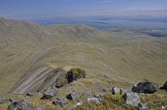
A rust-red, lava-streaked summit in the Morvern peninsula above Lochaline, with crags of weathered basalt giving the hill its name. The view stretches over the Sound of Mull to Ardnamurchan and across to the Small Isles on a good day.
Gaelic: “sharp peak, red” · Pronunciation: skoor jerr-ak
Quick facts
- Height
- 741m/ 2431ft
- Prominence
- 246 m
- Distance
- 14 km
- Ascent
- 608 m
- Time
- 4–7 hrs
- Grid ref
- NM665339
- Parking
- NM693432
- Nearest city
- Oban· 20km
- Dogs
- Dogs on lead required near livestockDog-friendly guide ↗
Height and prominence cross-checked against the Database of British and Irish Hills (CC BY).
No GPX track yet
Walked this route? Share your track to help other walkers.
Standard route
road access 15% · heather hillside 45% · grassy ridge 30% · summit area 10%
Park near the Lochaline road at Achabeg and take the forest tracks west, picking a line up the open south-east shoulder through bracken and onto the rocky summit dome. Pathless above the trees.
Terrain
Sitka forestry tracks low down then steep tussock and bracken; the upper hill has broken basalt outcrops requiring careful line-choice in mist.
In winter
Morvern rarely sees lasting snow but the basalt step-cliffs glaze with verglas after a wet thaw. Daylight constrains options December to February given the long drive from anywhere; few people pass this way.
Best time of year
Getting there
- Glasgow3h 57m
- Edinburgh4h 46m
Ferry access
Oban → Craignure
- Crossing time45 min
- Summer sailingsUp to 8 sailings daily (Apr–Oct)
- Winter sailings4–5 sailings daily (Nov–Mar)
- Book ahead7 days
- Last ferry backCheck CalMac timetable — sailings run until ~21:00 in peak summer
Foot passengers can usually turn up without booking. Book vehicle spaces in advance. The Lochaline → Fishnish crossing (15 min) is shorter but serves east Mull only.
Book on CalMac ↗OS maps: OS Landranger 49
Mobile signal: No coverage in this remote Glen Shiel/Cluanie area
Current conditions
Daylight Today
- Sunrise
- 04:58
- Sunset
- 22:01
- Civil dawn
- 04:01
- Civil dusk
- 22:57
NOAA Solar Calculator · 17 July 2026
Around Sgurr Dearg on the SCOT network
Getting there, basing yourself, and what to do off the hill.
Getting there: Oban station
Argyll ferry hub; Mull, Lismore, Coll, Tiree, Barra connections
20km from the hill
tripscot.co.uk
On TripSCOTBase yourself in Oban
Argyll ferry hub — Mull, Lismore, Coll, Tiree, Barra
20km from the hill
tripscot.co.uk
On TasteSCOTAfter the hill: Oban
Oban town centre — tiny two-still distillery bridging Highland and West Coast styles
20km from the hill
tastescot.co.uk
Sgurr Dearg — common questions
- Is Sgurr Dearg a hard climb?
- Sgurr Dearg is rated 4/5 (challenging) on the OutdoorSCOT scale. The standard route covers about 14km with 608m of ascent and takes most walkers 4-7 hours. Terrain: Sitka forestry tracks low down then steep tussock and bracken; the upper hill has broken basalt outcrops requiring careful line-choice in mist.
- How prominent is Sgurr Dearg?
- Sgurr Dearg has 246m of topographic prominence — the height of its summit above the highest col connecting it to higher ground.
- Where should I park to climb Sgurr Dearg?
- Standard parking is at NM693432. Check the parking grid reference on an OS map before travel; informal laybys can fill on summer weekends.
- When should I climb Sgurr Dearg?
- The standard good-weather months for Sgurr Dearg are May, June, July, August, September. Outside those months, expect winter conditions on the high ground — full mountain kit, navigation skills, and a check of the SAIS avalanche forecast for the relevant region.
- Can I bring my dog up Sgurr Dearg?
- On a lead only — the route crosses ground with livestock or nesting-bird interest.
- What's mobile reception like on Sgurr Dearg?
- No coverage in this remote Glen Shiel/Cluanie area
- How do I get the ferry to Sgurr Dearg?
- Oban → Craignure. Up to 8 sailings daily (Apr–Oct) in summer; 4–5 sailings daily (Nov–Mar) in winter. Book at least 7 days ahead. Foot passengers can usually turn up without booking. Book vehicle spaces in advance. The Lochaline → Fishnish crossing (15 min) is shorter but serves east Mull only.
- Is Sgurr Dearg safe in winter?
- Morvern rarely sees lasting snow but the basalt step-cliffs glaze with verglas after a wet thaw. Daylight constrains options December to February given the long drive from anywhere; few people pass this way.
Get the OutdoorSCOT weekly
One email a week — new route, hill and bothy guides, seasonal conditions and the odd hard-won lesson. No spam, unsubscribe in one click.