Graham · Argyll & Bute
Ben Buie
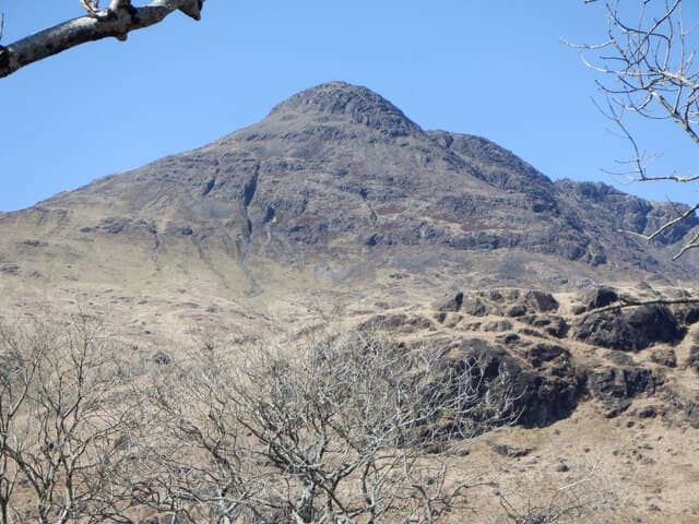
Ben Buie (718m) rises above Loch Spelve at NM60 in the south-east corner of Mull, a peridotite knob that earns its yellow-cream colour from weathered ultramafic rock. Its 515m of clean prominence makes it the most striking summit east of Ben More on the island, and the view from the cairn takes in the Sound of Mull, Lismore lighthouse, Cruachan and the Paps of Jura. Walkers based at Lochbuie or Croggan have it largely to themselves — Ben More steals the visiting crowds.
Quick facts
- Height
- 718.1m/ 2356ft
- Prominence
- 515 m
- Distance
- 13 km
- Ascent
- 589 m
- Time
- 4–6 hrs
- Grid ref
- NM604270
- Parking
- NM614302
- Nearest city
- Oban· 26km
- Dogs
- Dogs on lead required near livestockDog-friendly guide ↗
Height and prominence cross-checked against the Database of British and Irish Hills (CC BY).
No GPX track yet
Walked this route? Share your track to help other walkers.
Standard route
glen path 20% · heather hillside 45% · rocky upper slopes 25% · summit area 10%
From the Lochbuie roadhead near the Loch Spelve foreshore, take the farm track north-west and pick up a stalkers' path climbing the broad south ridge. The route eases over an interim shoulder before the final 200m pull onto the cairned crown. Around 13km return with 589m of ascent. The opposite (northern) approach from Glen More on the A849 is shorter but boggier and pathless.
Terrain
Peridotite gives a distinctive olive-coloured rocky upper hillside with stable boulders and short turf between. Lower flanks carry deer-grass and tussocks typical of Mull. The summit cairn sits on a small flat shoulder with steep ground falling east toward the Spelve cliffs — keep to the shoulder line in poor visibility.
In winter
Mull rarely holds prolonged snow at Graham altitude but Atlantic systems queue up off Tiree, driving sustained 60mph gusts onto the Buie ridge with little shelter. Verglaze on the peridotite boulders is the more common winter hazard than deep snow. The nearest official avalanche forecast (SAIS Lochaber, mainland) doesn't cover Mull; rely on local judgement.
Best time of year
Getting there
- Glasgow3h 58m
- Edinburgh4h 50m
Ferry access
Oban → Craignure
- Crossing time45 min
- Summer sailingsUp to 8 sailings daily (Apr–Oct)
- Winter sailings4–5 sailings daily (Nov–Mar)
- Book ahead7 days
- Last ferry backCheck CalMac timetable — sailings run until ~21:00 in peak summer
Foot passengers can usually turn up without booking. Book vehicle spaces in advance. The Lochaline → Fishnish crossing (15 min) is shorter but serves east Mull only.
Book on CalMac ↗OS maps: OS Landranger 49
Mobile signal: Brief signal on Mull — 1 bar possible on the summit
Current conditions
Daylight Today
- Sunrise
- 04:53
- Sunset
- 22:06
- Civil dawn
- 03:54
- Civil dusk
- 23:04
NOAA Solar Calculator · 13 July 2026
Pair with
Curated multi-hill combinations from Ben Buie.
Around Ben Buie on the SCOT network
Getting there, basing yourself, and what to do off the hill.
Getting there: Oban station
Argyll ferry hub; Mull, Lismore, Coll, Tiree, Barra connections
26km from the hill
tripscot.co.uk
On TripSCOTBase yourself in Oban
Argyll ferry hub — Mull, Lismore, Coll, Tiree, Barra
26km from the hill
tripscot.co.uk
On TasteSCOTAfter the hill: Oban
Oban town centre — tiny two-still distillery bridging Highland and West Coast styles
25km from the hill
tastescot.co.uk
Ben Buie — common questions
- Is Ben Buie a hard climb?
- Ben Buie is rated 4/5 (challenging) on the OutdoorSCOT scale. The standard route covers about 13km with 589m of ascent and takes most walkers 4-6 hours. Ground conditions: Peridotite gives a distinctive olive-coloured rocky upper hillside with stable boulders and short turf between.
- How much drop does Ben Buie have?
- The drop is 515m: measured from the summit of Ben Buie down to the saddle joining it to higher terrain.
- Where's the parking for Ben Buie?
- Park at NM614302. Double-check the grid reference on an OS map first; informal laybys here fill early in high season.
- What's the best month to climb Ben Buie?
- Aim for May, June, July, August, September on Ben Buie. In the remaining months treat it as a winter hill — full kit, solid navigation, and a look at the relevant SAIS avalanche forecast before you go.
- Can dogs go up Ben Buie?
- Dogs are fine on a lead. The route passes livestock or ground-nesting bird habitat, so keep them close throughout.
- Will I get phone signal on Ben Buie?
- Brief signal on Mull — 1 bar possible on the summit
- How do I get the ferry to Ben Buie?
- Oban → Craignure. Up to 8 sailings daily (Apr–Oct) in summer; 4–5 sailings daily (Nov–Mar) in winter. Book at least 7 days ahead. Foot passengers can usually turn up without booking. Book vehicle spaces in advance. The Lochaline → Fishnish crossing (15 min) is shorter but serves east Mull only.
- Is Ben Buie safe in winter?
- Mull rarely holds prolonged snow at Graham altitude but Atlantic systems queue up off Tiree, driving sustained 60mph gusts onto the Buie ridge with little shelter. Verglaze on the peridotite boulders is the more common winter hazard than deep snow. The nearest official avalanche forecast (SAIS Lochaber, mainland) doesn't cover Mull; rely on local judgement.
Get the OutdoorSCOT weekly
One email a week — new route, hill and bothy guides, seasonal conditions and the odd hard-won lesson. No spam, unsubscribe in one click.