Graham · Argyll & Bute
Creach-Beinn (Creach Beinn)
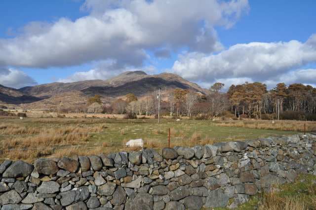
Creach-Beinn (698m) — the hill of plunder, named for cattle reivers who once mustered raids in its shadow — sits at the heart of Morvern in the NM62 square. With 552m of prominence it dominates the peninsula, looking out over Loch Linnhe to Ardgour and across the Sound of Mull to Ben More. The summit is a rocky bump on a long undulating ridge.
Quick facts
- Height
- 698.7m/ 2292ft
- Prominence
- 552 m
- Distance
- 13 km
- Ascent
- 572 m
- Time
- 3–6 hrs
- Grid ref
- NM642276
- Parking
- NM625275
- Nearest city
- Oban· 22km
- Dogs
- Dogs on lead required near livestockDog-friendly guide ↗
Height and prominence cross-checked against the Database of British and Irish Hills (CC BY).
No GPX track yet
Walked this route? Share your track to help other walkers.
Standard route
heather and bog 60% · grass slopes 25% · rocky summit 15%
From the parking lay-by on the B849 west of Lochaline take the forest track north into Coire na Cuile. Where the forestry ends a stalkers' path strikes east up the burn, fading at 400m into open hillside. Climb the south ridge directly: a fine breezy crest of schist and turf.
Terrain
Forest tracks at the start, then the path through Sitka plantation gives way to tussocky boggy ground above the treeline. The summit ridge has occasional schist outcrops but the going is generally cropped grass once over the worst of the bog at 350m.
In winter
Morvern's maritime climate keeps Creach-Beinn snow-free for most of the year, but Atlantic depressions occasionally dump quick wet falls that turn the schist slabs greasy. The exposed ridge becomes very windy in any westerly. Travel here in winter is rarely about snow technique and more about wading through clag and rain.
Best time of year
Getting there
- Glasgow3h 55m
- Edinburgh4h 46m
Ferry access
Oban → Craignure
- Crossing time45 min
- Summer sailingsUp to 8 sailings daily (Apr–Oct)
- Winter sailings4–5 sailings daily (Nov–Mar)
- Book ahead7 days
- Last ferry backCheck CalMac timetable — sailings run until ~21:00 in peak summer
Foot passengers can usually turn up without booking. Book vehicle spaces in advance. The Lochaline → Fishnish crossing (15 min) is shorter but serves east Mull only.
Book on CalMac ↗OS maps: OS Landranger 49
Mobile signal: Poor. Remote Morvern peninsula; very faint on most networks.
Current conditions
Daylight Today
- Sunrise
- 04:58
- Sunset
- 22:00
- Civil dawn
- 04:02
- Civil dusk
- 22:57
NOAA Solar Calculator · 17 July 2026
Around Creach-Beinn (Creach Beinn) on the SCOT network
Getting there, basing yourself, and what to do off the hill.
Getting there: Oban station
Argyll ferry hub; Mull, Lismore, Coll, Tiree, Barra connections
22km from the hill
tripscot.co.uk
On TripSCOTBase yourself in Oban
Argyll ferry hub — Mull, Lismore, Coll, Tiree, Barra
22km from the hill
tripscot.co.uk
On TasteSCOTAfter the hill: Oban
Oban town centre — tiny two-still distillery bridging Highland and West Coast styles
22km from the hill
tastescot.co.uk
Creach-Beinn (Creach Beinn) — common questions
- How hard is Creach-Beinn (Creach Beinn)?
- We grade Creach-Beinn (Creach Beinn) at 3/5, which puts it in moderately challenging territory. The usual route is around 13km with 572m of climbing; allow 3-6 hours. Ground conditions: Forest tracks at the start, then the path through Sitka plantation gives way to tussocky boggy ground above the treeline.
- How much drop does Creach-Beinn (Creach Beinn) have?
- The drop is 552m: measured from the summit of Creach-Beinn (Creach Beinn) down to the saddle joining it to higher terrain.
- Where's the parking for Creach-Beinn (Creach Beinn)?
- Park at NM625275. Double-check the grid reference on an OS map first; informal laybys here fill early in high season.
- What's the best month to climb Creach-Beinn (Creach Beinn)?
- Aim for May, June, July, August, September on Creach-Beinn (Creach Beinn). In the remaining months treat it as a winter hill — full kit, solid navigation, and a look at the relevant SAIS avalanche forecast before you go.
- Can dogs go up Creach-Beinn (Creach Beinn)?
- Dogs are fine on a lead. The route passes livestock or ground-nesting bird habitat, so keep them close throughout.
- Will I get phone signal on Creach-Beinn (Creach Beinn)?
- Poor. Remote Morvern peninsula; very faint on most networks.
- How do I get the ferry to Creach-Beinn (Creach Beinn)?
- Oban → Craignure. Up to 8 sailings daily (Apr–Oct) in summer; 4–5 sailings daily (Nov–Mar) in winter. Book at least 7 days ahead. Foot passengers can usually turn up without booking. Book vehicle spaces in advance. The Lochaline → Fishnish crossing (15 min) is shorter but serves east Mull only.
- Is Creach-Beinn (Creach Beinn) safe in winter?
- Morvern's maritime climate keeps Creach-Beinn snow-free for most of the year, but Atlantic depressions occasionally dump quick wet falls that turn the schist slabs greasy. The exposed ridge becomes very windy in any westerly. Travel here in winter is rarely about snow technique and more about wading through clag and rain.
Get the OutdoorSCOT weekly
One email a week — new route, hill and bothy guides, seasonal conditions and the odd hard-won lesson. No spam, unsubscribe in one click.