Corbett · Argyll & Bute
Dun da Ghaoithe
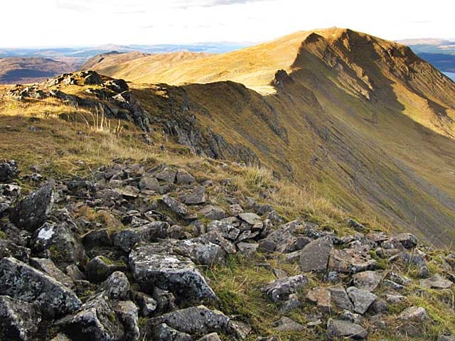
Dùn da Ghaoithe — 'the fort of two winds' — is Mull's main Corbett and the second-highest hill on the island after Ben More. The 766m summit sits at the northern end of a long ridge running south above the ferry route between Craignure and Oban, and gives one of the great viewpoints of the Inner Hebrides: across the Sound of Mull to Morvern and Ardnamurchan, south to Iona and the Treshnish Isles, north to the Cuillin of Skye on clear days, and east across the Firth of Lorn to the mainland. A good half-day walk from a roadside start.
Quick facts
- Height
- 766m/ 2513ft
- Prominence
- 659 m
- Distance
- 13 km
- Ascent
- 800 m
- Time
- 3–5 hrs
- Grid ref
- NM672362
- Parking
- NM724367
- Nearest city
- Oban· 20km
- Dogs
- Dogs on lead required near livestockDog-friendly guide ↗
Height and prominence cross-checked against the Database of British and Irish Hills (CC BY).
No GPX track yet
Walked this route? Share your track to help other walkers.
Standard route
woodland path 15% · heather hillside 45% · rocky upper slopes 30% · summit area 10%
Park at a layby on the A849 a short way north-west of Craignure (NM724367 area). Cross fields toward the obvious east-facing slope of the hill, climbing onto the broad south-east shoulder. The line follows the ridge north-west, picking up a vague path at the masts on Maol nan Damh, then continuing along the spine to the summit cairn of Dùn da Ghaoithe. Reverse the route to descend. Allow 5–6 hours for the round trip from the A849.
Terrain
Initial fields and rough pasture — gates and stiles. Above the in-bye land the ridge is broad grass and heather with peat hags and a few small rocky outcrops. The summit area is broad and flat with a substantial cairn. The southern half of the ridge is on Forestry and Land Scotland ground; the upper section is open hill.
In winter
A maritime hill with intermittent winter snow cover; when present, the wide ridge gives a fine winter walk with no avalanche issues. Wind on the exposed ridge can be ferocious — Mull catches the full Atlantic weather. Oban–Craignure sailings run through the winter, although heavy weather sometimes pauses the timetable; consult CalMac before committing to a date.
Best time of year
Getting there
- Glasgow3h 58m
- Edinburgh4h 46m
Ferry access
Oban → Craignure
- Crossing time45 min
- Summer sailingsUp to 8 sailings daily (Apr–Oct)
- Winter sailings4–5 sailings daily (Nov–Mar)
- Book ahead7 days
- Last ferry backCheck CalMac timetable — sailings run until ~21:00 in peak summer
Foot passengers can usually turn up without booking. Book vehicle spaces in advance. The Lochaline → Fishnish crossing (15 min) is shorter but serves east Mull only.
Book on CalMac ↗OS maps: OS Landranger 49
Mobile signal: Patchy on the lower fields; better on the upper ridge given clear sight of the Oban-area masts; reliable around Craignure
Current conditions
Daylight Today
- Sunrise
- 04:52
- Sunset
- 22:06
- Civil dawn
- 03:53
- Civil dusk
- 23:05
NOAA Solar Calculator · 13 July 2026
Pair with
Curated multi-hill combinations from Dun da Ghaoithe.
Around Dun da Ghaoithe on the SCOT network
Getting there, basing yourself, and what to do off the hill.
Getting there: Oban station
Argyll ferry hub; Mull, Lismore, Coll, Tiree, Barra connections
20km from the hill
tripscot.co.uk
On TripSCOTBase yourself in Oban
Argyll ferry hub — Mull, Lismore, Coll, Tiree, Barra
20km from the hill
tripscot.co.uk
On TasteSCOTAfter the hill: Oban
Oban town centre — tiny two-still distillery bridging Highland and West Coast styles
19km from the hill
tastescot.co.uk
Dun da Ghaoithe — common questions
- Is Dun da Ghaoithe a hard climb?
- Dun da Ghaoithe is rated 2/5 (moderate) on the OutdoorSCOT scale. The standard route covers about 13km with 800m of ascent and takes most walkers 3-5 hours. Terrain: Initial fields and rough pasture — gates and stiles.
- How prominent is Dun da Ghaoithe?
- Dun da Ghaoithe has 659m of topographic prominence — the height of its summit above the highest col connecting it to higher ground.
- Where should I park to climb Dun da Ghaoithe?
- Standard parking is at NM724367. Check the parking grid reference on an OS map before travel; informal laybys can fill on summer weekends.
- When should I climb Dun da Ghaoithe?
- The standard good-weather months for Dun da Ghaoithe are May, June, July, August, September. Outside those months, expect winter conditions on the high ground — full mountain kit, navigation skills, and a check of the SAIS avalanche forecast for the relevant region.
- Can I bring my dog up Dun da Ghaoithe?
- On a lead only — the route crosses ground with livestock or nesting-bird interest.
- What's mobile reception like on Dun da Ghaoithe?
- Patchy on the lower fields; better on the upper ridge given clear sight of the Oban-area masts; reliable around Craignure
- How do I get the ferry to Dun da Ghaoithe?
- Oban → Craignure. Up to 8 sailings daily (Apr–Oct) in summer; 4–5 sailings daily (Nov–Mar) in winter. Book at least 7 days ahead. Foot passengers can usually turn up without booking. Book vehicle spaces in advance. The Lochaline → Fishnish crossing (15 min) is shorter but serves east Mull only.
- Is Dun da Ghaoithe safe in winter?
- A maritime hill with intermittent winter snow cover; when present, the wide ridge gives a fine winter walk with no avalanche issues. Wind on the exposed ridge can be ferocious — Mull catches the full Atlantic weather. Oban–Craignure sailings run through the winter, although heavy weather sometimes pauses the timetable; consult CalMac before committing to a date.
Get the OutdoorSCOT weekly
One email a week — new route, hill and bothy guides, seasonal conditions and the odd hard-won lesson. No spam, unsubscribe in one click.