Graham · Argyll & Bute
Corra-bheinn
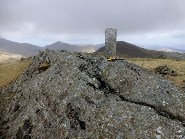
Corra-bheinn (704m) — the steep hill — at NM57 stands in the central spine of Mull above Glen More, between Ben More to the west and Beinn Talaidh to the east. A rocky outcrop crowns the summit with a view that spans the whole island: Iona offshore, the Treshnish chain to the north, Jura's Paps to the south, and on a rare clear day the entire mainland Cruachan group.
Quick facts
- Height
- 704.8m/ 2312ft
- Prominence
- 317 m
- Distance
- ~13 km
- Ascent
- ~577 m
- Time
- 4–6 hrs
- Grid ref
- NM573321
- Parking
- NM581320
- Nearest city
- Oban· 29km
- Dogs
- Dogs on lead required near livestockDog-friendly guide ↗
Height and prominence cross-checked against the Database of British and Irish Hills (CC BY).
No GPX track yet
Walked this route? Share your track to help other walkers.
Standard route
heather bog 55% · grass and deer sedge 30% · rocky summit 15%
From the Glen More road (A849) at NM581320, climb directly north up the steep south slope on faint trods through bracken and bog. The upper ground firms onto basalt outcrops and short turf. 13km return on the standard line, 577m of ascent — short in distance but steep. Pair with Ben Talaidh across the glen for a fuller Mull spine day.
Terrain
Bracken thick on the lower slopes hides boulders and turned-ankle traps — long trousers help in summer. Above 400m the going firms onto stable basalt with intermittent rock ribs. The summit outcrop is a small flat platform; the surrounding hills look much higher than they are from this vantage.
In winter
Mull rarely holds prolonged snow at Graham height but maritime gales drive horizontal sleet onto the south slope with sustained intensity. Verglas glazing the basalt outcrops is the dominant winter hazard rather than deep pack. Mainland Lochaber bulletins are the nearest formal reference. Midwinter daylight at this latitude runs to about seven and a half hours.
Kit for this: the winter Munro kit list · which boots take crampons
Best time of year
Getting there
- Glasgow3h 5m
- Edinburgh4h 55m
Ferry access
Oban → Craignure
- Crossing time45 min
- Summer sailingsUp to 8 sailings daily (Apr–Oct)
- Winter sailings4–5 sailings daily (Nov–Mar)
- Book ahead7 days
- Last ferry backCheck CalMac timetable — sailings run until ~21:00 in peak summer
Foot passengers can usually turn up without booking. Book vehicle spaces in advance. The Lochaline → Fishnish crossing (15 min) is shorter but serves east Mull only.
Book on CalMac ↗OS maps: OS Landranger 48
Mobile signal: Brief signal in Glen More — patchy on the slope; better on the summit toward Craignure.
Current conditions
Daylight Today
- Sunrise
- 07:53
- Sunset
- 18:27
- Civil dawn
- 07:15
- Civil dusk
- 19:05
NOAA Solar Calculator · 14 October 2026
Around Corra-bheinn on the SCOT network
Getting there, basing yourself, and what to do off the hill.
Getting there: Oban station
Argyll ferry hub; Mull, Lismore, Coll, Tiree, Barra connections
28km from the hill
tripscot.co.uk
On TripSCOTBase yourself in Tobermory
Mull base — Ben More, Treshnish, ferry to Iona
24km from the hill
tripscot.co.uk
On TasteSCOTAfter the hill: Tobermory
Mull — colourful harbour-front distillery making both unpeated and peated (Ledaig) whisky
24km from the hill
tastescot.co.uk
Corra-bheinn — common questions
- What difficulty is Corra-bheinn?
- On the OutdoorSCOT scale, Corra-bheinn comes in at 4/5 — challenging. Expect roughly 13km and 577m of ascent on the usual route — 4-6 hours for most parties. Underfoot: Bracken thick on the lower slopes hides boulders and turned-ankle traps — long trousers help in summer.
- What is Corra-bheinn's prominence?
- 317m of prominence. That's the vertical drop from the summit to the col that links Corra-bheinn to the next higher ground.
- Where do I park for Corra-bheinn?
- Most walkers start from NM581320. Verify the grid reference on an OS map before you set off — space is tight on busy summer weekends.
- When is the best time to climb Corra-bheinn?
- May, June, July, August, September give the most reliable conditions on Corra-bheinn. Beyond that window the high ground turns wintry: carry full mountain kit, be confident navigating, and check the SAIS avalanche forecast for the area.
- Is Corra-bheinn dog-friendly?
- Yes, but dogs must be kept on a lead — there is livestock or ground-nesting bird interest on the route.
- Is there mobile signal on Corra-bheinn?
- Brief signal in Glen More — patchy on the slope; better on the summit toward Craignure.
- How do I get the ferry to Corra-bheinn?
- Oban → Craignure. Up to 8 sailings daily (Apr–Oct) in summer; 4–5 sailings daily (Nov–Mar) in winter. Book at least 7 days ahead. Foot passengers can usually turn up without booking. Book vehicle spaces in advance. The Lochaline → Fishnish crossing (15 min) is shorter but serves east Mull only.
- Is Corra-bheinn safe in winter?
- Mull rarely holds prolonged snow at Graham height but maritime gales drive horizontal sleet onto the south slope with sustained intensity. Verglas glazing the basalt outcrops is the dominant winter hazard rather than deep pack. Mainland Lochaber bulletins are the nearest formal reference. Midwinter daylight at this latitude runs to about seven and a half hours.
Get the OutdoorSCOT weekly
One email a week — new route, hill and bothy guides, seasonal conditions and the odd hard-won lesson. No spam, unsubscribe in one click.