Donald · Galloway
Lamachan Hill
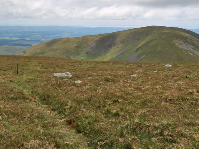
South of Loch Trool, Lamachan Hill anchors a wild moorland group facing the Merrick range across Glentrool. A solitary boulder sitting half-sunk in the grass marks its top, with a panoramic view down to Wigtown Bay and out over the inner Solway.
Quick facts
- Height
- 716.7m/ 2351ft
- Prominence
- 453 m
- Distance
- 13 km
- Ascent
- 587 m
- Time
- 3–6 hrs
- Grid ref
- NX435769
- Parking
- NX449786
- Nearest city
- Dumfries· 54km
- Dogs
- Dogs on lead required near livestockDog-friendly guide ↗
Height and prominence cross-checked against the Database of British and Irish Hills (CC BY).
No GPX track yet
Walked this route? Share your track to help other walkers.
Standard route
heather moorland 50% · granite boulders 30% · grass moorland 20%
From the Bruce's Stone car park, cross the bridge at Caldons and head up by Glenhead and the Buchan Burn before climbing onto Curleywee, then traverse west onto Lamachan. A pleasant if rough circuit returns by Mulldonoch.
Terrain
Old quarry path through young plantation, then wet heather and granite slabs. Once on the broad summit dome the ground is dry, springy, and remarkably pleasant — Galloway at its best.
In winter
A south-west exposure makes for early thaws and heavy rain rather than reliable freeze. When cold does arrive the granite slabs stay icy long after the heather has cleared. Bring spikes for the descent line to Bruce's Stone.
Best time of year
Getting there
- Glasgow2h 54m
- Edinburgh3h 42m
OS maps: OS Landranger 77
Mobile signal: Variable. EE hit and miss; coverage limited in this Galloway interior location.
Current conditions
Daylight Today
- Sunrise
- 05:01
- Sunset
- 21:47
- Civil dawn
- 04:09
- Civil dusk
- 22:39
NOAA Solar Calculator · 17 July 2026
Pair with
Curated multi-hill combinations from Lamachan Hill.
Around Lamachan Hill on the SCOT network
Getting there, basing yourself, and what to do off the hill.
Getting there: Ayr station
Ayrshire coast; Galloway approach via bus/car
46km from the hill
tripscot.co.uk
On TripSCOTBase yourself in Kirkcudbright
Galloway base — Solway coast, Galloway Forest, Mull of Galloway Trail
36km from the hill
tripscot.co.uk
On TasteSCOTAfter the hill: Bladnoch
Wigtown — Galloway's only distillery; Scotland's most southerly
23km from the hill
tastescot.co.uk
Lamachan Hill — common questions
- Is Lamachan Hill a hard climb?
- Lamachan Hill is rated 3/5 (moderately challenging) on the OutdoorSCOT scale. The standard route covers about 13km with 587m of ascent and takes most walkers 3-6 hours. Underfoot: Old quarry path through young plantation, then wet heather and granite slabs.
- What is Lamachan Hill's prominence?
- 453m of prominence. That's the vertical drop from the summit to the col that links Lamachan Hill to the next higher ground.
- Where do I park for Lamachan Hill?
- Most walkers start from NX449786. Verify the grid reference on an OS map before you set off — space is tight on busy summer weekends.
- When is the best time to climb Lamachan Hill?
- April, May, June, July, August, September, October give the most reliable conditions on Lamachan Hill. Beyond that window the high ground turns wintry: carry full mountain kit, be confident navigating, and check the SAIS avalanche forecast for the area.
- Is Lamachan Hill dog-friendly?
- Yes, but dogs must be kept on a lead — there is livestock or ground-nesting bird interest on the route.
- Is there mobile signal on Lamachan Hill?
- Variable. EE hit and miss; coverage limited in this Galloway interior location.
- Is Lamachan Hill safe in winter?
- A south-west exposure makes for early thaws and heavy rain rather than reliable freeze. When cold does arrive the granite slabs stay icy long after the heather has cleared. Bring spikes for the descent line to Bruce's Stone.
Get the OutdoorSCOT weekly
One email a week — new route, hill and bothy guides, seasonal conditions and the odd hard-won lesson. No spam, unsubscribe in one click.