Donald · Southern Uplands
Green Lowther
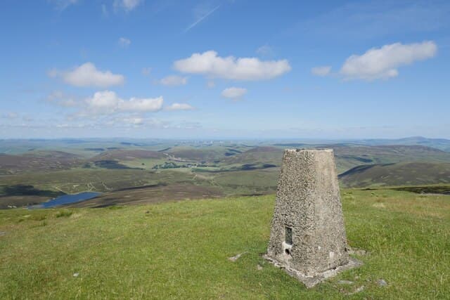
The actual high point of the Lowthers, slightly higher than its more celebrated twin Lowther Hill, Green Lowther carries Civil Aviation Authority radar masts and a cluster of low concrete shelters. The drive up the access road from Wanlockhead makes this the easiest 2400-foot top in Scotland.
Quick facts
- Height
- 732m/ 2402ft
- Prominence
- 424 m
- Distance
- 14 km
- Ascent
- 600 m
- Time
- 4–6 hrs
- Grid ref
- NS900120
- Parking
- NS994154
- Nearest city
- Dumfries· 37km
- Dogs
- Dogs on lead required near livestockDog-friendly guide ↗
Height and prominence cross-checked against the Database of British and Irish Hills (CC BY).
No GPX track yet
Walked this route? Share your track to help other walkers.
Standard route
grass moorland 75% · heather slopes 20% · summit area 5%
From Wanlockhead — the highest village in Scotland — follow the radar service road to Lowther Hill then walk the level ridge south-east to Green Lowther's trig pillar. Returning the same way takes just over two hours.
Terrain
Service tarmac most of the way to the radar dome and then a stony track east. Easy walking on flat sheep pasture between the two summits; off the track the ground is short heath and dry peat.
In winter
The CAA grit the access road right up to the radar station, which makes Green Lowther one of the few Donalds you can reach in trainers on a winter weekday — at least until you step off the tarmac. The plateau picks up plenty of drifting snow.
Best time of year
Getting there
- Glasgow1h 28m
- Edinburgh2h 42m
OS maps: OS Landranger 71, OS Landranger 78
Mobile signal: Excellent summit coverage; strong on all networks. Near the Lowther Hills radar station.
Current conditions
Daylight Today
- Sunrise
- 04:51
- Sunset
- 21:51
- Civil dawn
- 03:56
- Civil dusk
- 22:46
NOAA Solar Calculator · 13 July 2026
Pair with
Curated multi-hill combinations from Green Lowther.
On a long-distance route
Green Lowther sits within 5km of these named long-distance walks — useful for trail-pack rest days or section extensions.
Around Green Lowther on the SCOT network
Getting there, basing yourself, and what to do off the hill.
Green Lowther — common questions
- Is Green Lowther a hard climb?
- Green Lowther is rated 3/5 (moderately challenging) on the OutdoorSCOT scale. The standard route covers about 14km with 600m of ascent and takes most walkers 4-6 hours. Terrain: Service tarmac most of the way to the radar dome and then a stony track east.
- How prominent is Green Lowther?
- Green Lowther has 424m of topographic prominence — the height of its summit above the highest col connecting it to higher ground.
- Where should I park to climb Green Lowther?
- Standard parking is at NS994154. Check the parking grid reference on an OS map before travel; informal laybys can fill on summer weekends.
- When should I climb Green Lowther?
- The standard good-weather months for Green Lowther are April, May, June, July, August, September, October. Outside those months, expect winter conditions on the high ground — full mountain kit, navigation skills, and a check of the SAIS avalanche forecast for the relevant region.
- Can I bring my dog up Green Lowther?
- On a lead only — the route crosses ground with livestock or nesting-bird interest.
- What's mobile reception like on Green Lowther?
- Excellent summit coverage; strong on all networks. Near the Lowther Hills radar station.
- Is Green Lowther safe in winter?
- The CAA grit the access road right up to the radar station, which makes Green Lowther one of the few Donalds you can reach in trainers on a winter weekday — at least until you step off the tarmac. The plateau picks up plenty of drifting snow.
Get the OutdoorSCOT weekly
One email a week — new route, hill and bothy guides, seasonal conditions and the odd hard-won lesson. No spam, unsubscribe in one click.