Donald · Southern Uplands
Lousie Wood Law (Louise Wood Law)
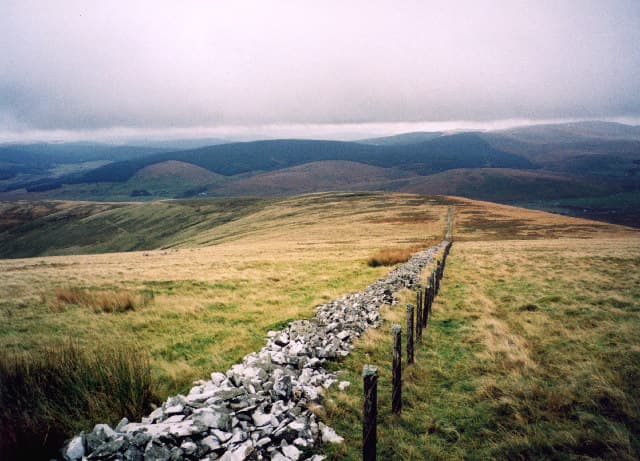
Lousie Wood Law (619m) is a grassy whaleback in the upper Clyde valley between Crawfordjohn and Abington, a hill better known for its silence than its drama. A cairn caps the broad summit and the ground falls gently in all directions. The hill is part of the empty country between the Lowther Hills and the Tweedsmuirs — high pastoral ground criss-crossed by old drove roads from Carstairs to Sanquhar.
Quick facts
- Height
- 619m/ 2031ft
- Prominence
- 123 m
- Distance
- ~12 km
- Ascent
- ~464 m
- Time
- 3–5 hrs
- Grid ref
- NS932152
- Parking
- NS926146
- Nearest city
- Dumfries· 39km
- Dogs
- Dogs on lead required near livestockDog-friendly guide ↗
Height and prominence cross-checked against the Database of British and Irish Hills (CC BY).
No GPX track yet
Walked this route? Share your track to help other walkers.
Standard route
grass moorland 80% · heather patches 15% · summit area 5%
A short approach climbs from the minor road at NS945178 east of Crawfordjohn, following an estate track south-west onto open hill before drifting up the broad grassy north-east ridge — 12km with 464m of ascent if extended over neighbouring tops. The track is good; the open hill is cropped grass with intermittent quad lines. The cairn is small but visible against the open sky from some distance.
Terrain
Wide pastoral grass underfoot, with the occasional stretch of peat hag and rushy bog where the watershed broadens. Old hill fences and the remains of drove roads carve straight lines across the slopes — useful for keeping a bearing. The ground is open access and lightly stocked with sheep year-round.
In winter
Lousie Wood Law's low-key terrain hides the seriousness of upper Clyde weather — easterly cold continentals bring deep cold and the saturated pasture freezes into ankle-twisting tussock. There are no crag features to fix a position on in cloud and the broad summit dome can swallow walkers in whiteout. The Lowther radar dome is the only visual anchor on the southern horizon.
Kit for this: the winter Munro kit list · which boots take crampons
Best time of year
Getting there
- Glasgow1h 26m
- Edinburgh2h 36m
OS maps: OS Landranger 71, OS Landranger 78
Current conditions
Daylight Today
- Sunrise
- 07:42
- Sunset
- 18:19
- Civil dawn
- 07:05
- Civil dusk
- 18:56
NOAA Solar Calculator · 14 October 2026
Around Lousie Wood Law (Louise Wood Law) on the SCOT network
Getting there, basing yourself, and what to do off the hill.
Lousie Wood Law (Louise Wood Law) — common questions
- Is Lousie Wood Law (Louise Wood Law) a hard climb?
- Lousie Wood Law (Louise Wood Law) is rated 3/5 (moderately challenging) on the OutdoorSCOT scale. The standard route covers about 12km with 464m of ascent and takes most walkers 3-5 hours. Terrain: Wide pastoral grass underfoot, with the occasional stretch of peat hag and rushy bog where the watershed broadens.
- How prominent is Lousie Wood Law (Louise Wood Law)?
- Lousie Wood Law (Louise Wood Law) has 123m of topographic prominence — the height of its summit above the highest col connecting it to higher ground.
- Where should I park to climb Lousie Wood Law (Louise Wood Law)?
- Standard parking is at NS926146. Check the parking grid reference on an OS map before travel; informal laybys can fill on summer weekends.
- When should I climb Lousie Wood Law (Louise Wood Law)?
- The standard good-weather months for Lousie Wood Law (Louise Wood Law) are March, April, May, June, July, August, September, October, November. Outside those months, expect winter conditions on the high ground — full mountain kit, navigation skills, and a check of the SAIS avalanche forecast for the relevant region.
- Can I bring my dog up Lousie Wood Law (Louise Wood Law)?
- On a lead only — the route crosses ground with livestock or nesting-bird interest.
- Is Lousie Wood Law (Louise Wood Law) safe in winter?
- Lousie Wood Law's low-key terrain hides the seriousness of upper Clyde weather — easterly cold continentals bring deep cold and the saturated pasture freezes into ankle-twisting tussock. There are no crag features to fix a position on in cloud and the broad summit dome can swallow walkers in whiteout. The Lowther radar dome is the only visual anchor on the southern horizon.
Get the OutdoorSCOT weekly
One email a week — new route, hill and bothy guides, seasonal conditions and the odd hard-won lesson. No spam, unsubscribe in one click.