Donald · Southern Uplands
East Mount Lowther
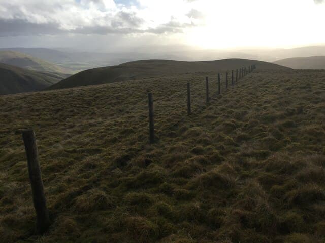
East Mount Lowther (631m) overlooks the lead-mining village of Wanlockhead — Scotland's highest — and is one of the most accessible Donalds in the country. A topograph viewpoint indicator on the summit names a panorama that reaches from the Galloway Hills to the Pentlands. The hill sits within the Lowther Hills group alongside its taller neighbour Lowther Hill with its prominent radar dome.
Quick facts
- Height
- 631m/ 2070ft
- Prominence
- 76 m
- Distance
- 12 km
- Ascent
- 473 m
- Time
- 3–5 hrs
- Grid ref
- NS878099
- Parking
- NS881105
- Nearest city
- Dumfries· 35km
- Dogs
- Dogs on lead required near livestockDog-friendly guide ↗
Height and prominence cross-checked against the Database of British and Irish Hills (CC BY).
No GPX track yet
Walked this route? Share your track to help other walkers.
Standard route
grass moorland 75% · heather slopes 20% · summit area 5%
From the car park at the Museum of Lead Mining in Wanlockhead a clear path strikes south-east up the grassy slopes to East Mount Lowther — 12km with 473m of ascent if continued onto Lowther Hill. The going is on cropped sheep grass with a stile and faint path the whole way. The topograph is a fine perch for a lunch stop and an easy retreat point in deteriorating weather.
Terrain
Short grass cropped by Blackface sheep covers the entire route — the easiest underfoot of any Lowther Hill. A clear path runs from Wanlockhead and stiled fences give natural waypoints. The radar service road on Lowther Hill is a useful escape route in bad weather, though it adds distance to the descent.
In winter
Sitting above the highest village in Scotland, East Mount Lowther catches early and late snow that may close the Mennock Pass below. The cropped grass turns to bullet-hard ice under hard frost and the topograph offers no shelter from the wind that funnels over from Lowther Hill. The radar dome is a visual catching feature even in poor weather.
Best time of year
Getting there
- Glasgow1h 29m
- Edinburgh2h 46m
OS maps: OS Landranger 71, OS Landranger 78
Mobile signal: Excellent coverage topside; strong on all networks. Close to Lowther Hills radar station.
Current conditions
Daylight Today
- Sunrise
- 04:51
- Sunset
- 21:51
- Civil dawn
- 03:56
- Civil dusk
- 22:45
NOAA Solar Calculator · 13 July 2026
On a long-distance route
East Mount Lowther sits within 5km of these named long-distance walks — useful for trail-pack rest days or section extensions.
Around East Mount Lowther on the SCOT network
Getting there, basing yourself, and what to do off the hill.
East Mount Lowther — common questions
- Is East Mount Lowther a hard climb?
- East Mount Lowther is rated 3/5 (moderately challenging) on the OutdoorSCOT scale. The standard route covers about 12km with 473m of ascent and takes most walkers 3-5 hours. Ground conditions: Short grass cropped by Blackface sheep covers the entire route — the easiest underfoot of any Lowther Hill.
- How much drop does East Mount Lowther have?
- The drop is 76m: measured from the summit of East Mount Lowther down to the saddle joining it to higher terrain.
- Where's the parking for East Mount Lowther?
- Park at NS881105. Double-check the grid reference on an OS map first; informal laybys here fill early in high season.
- What's the best month to climb East Mount Lowther?
- Aim for March, April, May, June, July, August, September, October, November on East Mount Lowther. In the remaining months treat it as a winter hill — full kit, solid navigation, and a look at the relevant SAIS avalanche forecast before you go.
- Can dogs go up East Mount Lowther?
- Dogs are fine on a lead. The route passes livestock or ground-nesting bird habitat, so keep them close throughout.
- Will I get phone signal on East Mount Lowther?
- Excellent coverage topside; strong on all networks. Close to Lowther Hills radar station.
- Is East Mount Lowther safe in winter?
- Sitting above the highest village in Scotland, East Mount Lowther catches early and late snow that may close the Mennock Pass below. The cropped grass turns to bullet-hard ice under hard frost and the topograph offers no shelter from the wind that funnels over from Lowther Hill. The radar dome is a visual catching feature even in poor weather.
Get the OutdoorSCOT weekly
One email a week — new route, hill and bothy guides, seasonal conditions and the odd hard-won lesson. No spam, unsubscribe in one click.