Graham · Southern Uplands
Well Hill
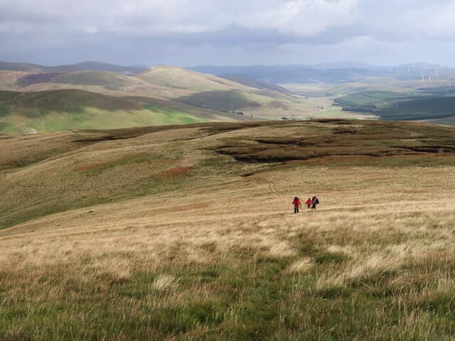
Well Hill (606m) is a grassy Lowther Graham at NS91, set on the boundary between South Lanarkshire and Dumfries and Galloway above the lead-mining village of Wanlockhead. The high point is a fence junction beside a small cairn, with the ground rolling away in long pastoral curves toward Lowther Hill's radome to the north-east and the upper reaches of the Mennock Pass to the south. The hill sees few walkers despite easy roadside access.
Quick facts
- Height
- 606m/ 1988ft
- Prominence
- 200 m
- Distance
- 12 km
- Ascent
- 454 m
- Time
- 3–5 hrs
- Grid ref
- NS913064
- Parking
- NS916059
- Nearest city
- Dumfries· 31km
- Dogs
- Dogs on lead required near livestockDog-friendly guide ↗
Height and prominence cross-checked against the Database of British and Irish Hills (CC BY).
No GPX track yet
Walked this route? Share your track to help other walkers.
Standard route
grass moorland 80% · heather patches 15% · summit area 5%
A direct line from the layby at NS916059 climbs the south ridge through old sheep drains, crossing the watershed fence onto the broad summit pasture. The full traverse to neighbouring Cold Moss extends the day to around 12km with 454m of climb, but the summit alone is reachable in under an hour each way. There is no constructed path — follow the fence line up the open hill and the navigation looks after itself.
Terrain
Almost entirely short grass and rushes throughout, with sheep paths threading the lower flanks and the boundary fence providing a handrail for the whole climb. A few peat groughs cut the upper ridge but they are easily turned. The watershed plateau is broad enough that a compass bearing is sensible if the cloud is down — the fence is the safest line of all.
In winter
For a hill this low Well Hill catches a surprising amount of east-coast snow, the upper pasture sometimes lying white for weeks at a time. Drifts pile against the boundary fence and bury the smaller cairns. With the SAIS region not covering the Southern Uplands, judgement falls to the walker — but the angle is gentle and the avalanche risk minimal compared with the Highland glens.
Best time of year
Getting there
- Glasgow2h 36m
- Edinburgh2h 48m
OS maps: OS Landranger 71, OS Landranger 78
Mobile signal: Signal is good; EE works well. Prominent Southern Uplands viewpoint.
Current conditions
Daylight Today
- Sunrise
- 04:51
- Sunset
- 21:50
- Civil dawn
- 03:56
- Civil dusk
- 22:45
NOAA Solar Calculator · 13 July 2026
Around Well Hill on the SCOT network
Getting there, basing yourself, and what to do off the hill.
Well Hill — common questions
- How difficult is Well Hill?
- Well Hill carries a 3/5 (moderately challenging) grade on the OutdoorSCOT scale. Count on about 12km, 454m of ascent and a 3-5 hour day on the standard route. Terrain: Almost entirely short grass and rushes throughout, with sheep paths threading the lower flanks and the boundary fence providing a handrail for the whole climb.
- How prominent is Well Hill?
- Well Hill has 200m of topographic prominence — the height of its summit above the highest col connecting it to higher ground.
- Where should I park to climb Well Hill?
- Standard parking is at NS916059. Check the parking grid reference on an OS map before travel; informal laybys can fill on summer weekends.
- When should I climb Well Hill?
- The standard good-weather months for Well Hill are March, April, May, June, July, August, September, October, November. Outside those months, expect winter conditions on the high ground — full mountain kit, navigation skills, and a check of the SAIS avalanche forecast for the relevant region.
- Can I bring my dog up Well Hill?
- On a lead only — the route crosses ground with livestock or nesting-bird interest.
- What's mobile reception like on Well Hill?
- Signal is good; EE works well. Prominent Southern Uplands viewpoint.
- Is Well Hill safe in winter?
- For a hill this low Well Hill catches a surprising amount of east-coast snow, the upper pasture sometimes lying white for weeks at a time. Drifts pile against the boundary fence and bury the smaller cairns. With the SAIS region not covering the Southern Uplands, judgement falls to the walker — but the angle is gentle and the avalanche risk minimal compared with the Highland glens.
Get the OutdoorSCOT weekly
One email a week — new route, hill and bothy guides, seasonal conditions and the odd hard-won lesson. No spam, unsubscribe in one click.