Donald · Borders
Gathersnow Hill
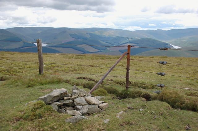
Gathersnow Hill sits at the head of the Holms Water on the eastern arm of the Culter Fell range. True to its name, snow lingers in the corrie north of the cairn long after the surrounding hills have cleared. A weathered fence corner doubles as a windbreak.
Quick facts
- Height
- 689.5m/ 2262ft
- Prominence
- 211 m
- Distance
- 13 km
- Ascent
- 565 m
- Time
- 3–6 hrs
- Grid ref
- NT058256
- Parking
- NT057266
- Nearest city
- Dumfries· 50km
- Dogs
- Dogs on lead required near livestockDog-friendly guide ↗
Height and prominence cross-checked against the Database of British and Irish Hills (CC BY).
No GPX track yet
Walked this route? Share your track to help other walkers.
Standard route
grass moorland 80% · heather patches 15% · summit area 5%
The standard approach is from Coulter village by way of Culter Fell, traversing south along the watershed for an in-out tag. About 18km return with 750m of climb if linked with Culter Fell.
Terrain
Short turf and bilberry on the rounded top, with deeper heather on the eastern flank towards Glenholm. The Culter Fell to Gathersnow ridge is wide and forgiving underfoot.
In winter
Long-lying snow patches are the namesake here — drifts in the north-east hollow can persist into May. Whiteout disorientation on the broad top is a real risk; the fence north back to Culter Fell is the safest bail line.
Best time of year
Getting there
- Glasgow1h 27m
- Edinburgh1h 15m
OS maps: OS Landranger 72
Mobile signal: Good signal throughout; count on EE. Fine views across Pentlands and Moorfoot.
Current conditions
Daylight Today
- Sunrise
- 04:49
- Sunset
- 21:51
- Civil dawn
- 03:54
- Civil dusk
- 22:46
NOAA Solar Calculator · 13 July 2026
Pair with
Curated multi-hill combinations from Gathersnow Hill.
Around Gathersnow Hill on the SCOT network
Getting there, basing yourself, and what to do off the hill.
Gathersnow Hill — common questions
- How difficult is Gathersnow Hill?
- Gathersnow Hill carries a 3/5 (moderately challenging) grade on the OutdoorSCOT scale. Count on about 13km, 565m of ascent and a 3-6 hour day on the standard route. Terrain: Short turf and bilberry on the rounded top, with deeper heather on the eastern flank towards Glenholm.
- How prominent is Gathersnow Hill?
- Gathersnow Hill has 211m of topographic prominence — the height of its summit above the highest col connecting it to higher ground.
- Where should I park to climb Gathersnow Hill?
- Standard parking is at NT057266. Check the parking grid reference on an OS map before travel; informal laybys can fill on summer weekends.
- When should I climb Gathersnow Hill?
- The standard good-weather months for Gathersnow Hill are March, April, May, June, July, August, September, October, November. Outside those months, expect winter conditions on the high ground — full mountain kit, navigation skills, and a check of the SAIS avalanche forecast for the relevant region.
- Can I bring my dog up Gathersnow Hill?
- On a lead only — the route crosses ground with livestock or nesting-bird interest.
- What's mobile reception like on Gathersnow Hill?
- Good signal throughout; count on EE. Fine views across Pentlands and Moorfoot.
- Is Gathersnow Hill safe in winter?
- Long-lying snow patches are the namesake here — drifts in the north-east hollow can persist into May. Whiteout disorientation on the broad top is a real risk; the fence north back to Culter Fell is the safest bail line.
Get the OutdoorSCOT weekly
One email a week — new route, hill and bothy guides, seasonal conditions and the odd hard-won lesson. No spam, unsubscribe in one click.