Graham · Southern Uplands
Tinto
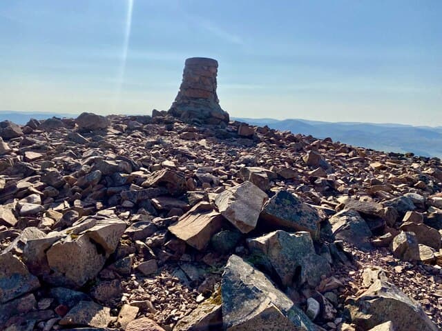
Tinto (711m) is the great red hill of Clydesdale at NS95, rising in solitary splendour from rolling farmland between Lanark and Biggar. Its Bronze Age summit cairn — one of the largest in Scotland at around 6m high and 45m across — has been a landmark for four millennia. Views on a clear day reach from Goatfell on Arran to the Cheviots, from the Cumbrian Lakes to the Pentlands. Few Scottish hills are so widely loved by their local communities.
Quick facts
- Height
- 711.6m/ 2335ft
- Prominence
- 443 m
- Distance
- 13 km
- Ascent
- 583 m
- Time
- 3–6 hrs
- Grid ref
- NS953343
- Parking
- NS964374
- Nearest
- Glasgow· Glasgow 47km
- Dogs
- Dogs on lead required near livestockDog-friendly guide ↗
Height and prominence cross-checked against the Database of British and Irish Hills (CC BY).
No GPX track yet
Walked this route? Share your track to help other walkers.
Standard route
grassy path 30% · moorland path 40% · stony summit path 20% · summit area 10%
From the Tinto Hill car park at Fallburn (NS964374), the public path strikes south-east up the broad north ridge, gaining height steadily on a well-worn stone surface. A clear shoulder at Totherin Hill marks the halfway point before the final pull to the summit cairn. 13km out-and-back, 583m climbed — the most-walked hill route in the Southern Uplands.
Terrain
The eroded main path has been substantially repaired with imported aggregate, giving solid footing for the entire ascent. The northern flank carries cropped sheep turf either side of the trail. Watch for foot-twisting hidden burns where springs emerge through the path. The summit cairn is unmistakable in any visibility.
In winter
Tinto's red felsite holds verglas readily and the open shoulder catches drifting snow in every direction. The relevant SAIS Southern Uplands forecast applies. Whiteout on the broad summit dome is genuinely disorienting; the path is usually visible as a line of darker ground, but if buried, compass-and-pacing back to the shoulder of Totherin is essential.
Best time of year
Getting there
- Glasgow1h 8m
- Edinburgh1h 11m
OS maps: OS Landranger 72
Mobile signal: Excellent signal — Tinto Hill is one of the most prominent radio relay points in central Scotland
Current conditions
Daylight Today
- Sunrise
- 04:49
- Sunset
- 21:52
- Civil dawn
- 03:54
- Civil dusk
- 22:47
NOAA Solar Calculator · 13 July 2026
Pair with
Curated multi-hill combinations from Tinto.
Around Tinto on the SCOT network
Getting there, basing yourself, and what to do off the hill.
Tinto — common questions
- How difficult is Tinto?
- Tinto carries a 3/5 (moderately challenging) grade on the OutdoorSCOT scale. Count on about 13km, 583m of ascent and a 3-6 hour day on the standard route. Ground conditions: The eroded main path has been substantially repaired with imported aggregate, giving solid footing for the entire ascent.
- How much drop does Tinto have?
- The drop is 443m: measured from the summit of Tinto down to the saddle joining it to higher terrain.
- Where's the parking for Tinto?
- Park at NS964374 near Glasgow. Double-check the grid reference on an OS map first; informal laybys here fill early in high season.
- What's the best month to climb Tinto?
- Aim for April, May, June, July, August, September, October on Tinto. In the remaining months treat it as a winter hill — full kit, solid navigation, and a look at the relevant SAIS avalanche forecast before you go.
- Can dogs go up Tinto?
- Dogs are fine on a lead. The route passes livestock or ground-nesting bird habitat, so keep them close throughout.
- Will I get phone signal on Tinto?
- Excellent signal — Tinto Hill is one of the most prominent radio relay points in central Scotland
- Is Tinto safe in winter?
- Tinto's red felsite holds verglas readily and the open shoulder catches drifting snow in every direction. The relevant SAIS Southern Uplands forecast applies. Whiteout on the broad summit dome is genuinely disorienting; the path is usually visible as a line of darker ground, but if buried, compass-and-pacing back to the shoulder of Totherin is essential.
Get the OutdoorSCOT weekly
One email a week — new route, hill and bothy guides, seasonal conditions and the odd hard-won lesson. No spam, unsubscribe in one click.