Donald · Borders
Hudderstone
Hudderstone (626m) is an outlier of the Culter Fell group, a rounded grassy summit on the watershed between Coulter Water and the headwaters of the Medwin. The top is featureless bare ground amid cropped grass and offers wide views across the upper Clyde valley to the Pentlands. It is most often climbed as a satellite of Culter Fell rather than as a primary objective.
Quick facts
- Height
- 626m/ 2054ft
- Prominence
- 111 m
- Distance
- 12 km
- Ascent
- 470 m
- Time
- 3–5 hrs
- Grid ref
- NT022271
- Parking
- NT036255
- Nearest city
- Dumfries· 51km
- Dogs
- Dogs on lead required near livestockDog-friendly guide ↗
Height and prominence cross-checked against the Database of British and Irish Hills (CC BY).
No GPX track yet
Walked this route? Share your track to help other walkers.
Standard route
grass moorland 80% · heather patches 15% · summit area 5%
A clean line begins at Coulter Reservoir at NT037289 and follows the access track along the loch before climbing south on the broad pasture ridge over Hillshaw Head to Hudderstone — 12km with 470m of ascent. The reservoir track makes for a fast walk-in and the upper ridge is on close-cropped grass with intermittent quad tracks. The summit may be combined with Coulter Fell for a longer round.
Terrain
Smooth sheep-grazed pasture all the way once off the reservoir track. The summit ridge is broad and rolling with intermittent peat hags where the grass thins. A march fence runs along the watershed and offers reliable navigation from Hillshaw Head onward. Open access land throughout, with no significant boundary issues.
In winter
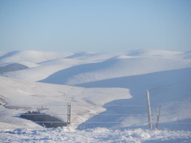
The upper Clyde catchment funnels Atlantic depressions hard against these hills and Hudderstone's broad top fills with drifted snow that softens to slush in mild interludes. The reservoir access track usually remains walkable, but the open plateau ices over in dry frost. No crag features means cornicing is not a concern, but compass discipline matters in cloud.
Best time of year
Getting there
- Glasgow1h 22m
- Edinburgh1h 15m
OS maps: OS Landranger 72
Mobile signal: Strong summit reception; EE behaves well. Southern Uplands minor summit.
Current conditions
Daylight Today
- Sunrise
- 04:49
- Sunset
- 21:51
- Civil dawn
- 03:54
- Civil dusk
- 22:46
NOAA Solar Calculator · 13 July 2026
Around Hudderstone on the SCOT network
Getting there, basing yourself, and what to do off the hill.
Hudderstone — common questions
- How hard is Hudderstone?
- We grade Hudderstone at 3/5, which puts it in moderately challenging territory. The usual route is around 12km with 470m of climbing; allow 3-5 hours. Terrain: Smooth sheep-grazed pasture all the way once off the reservoir track.
- How prominent is Hudderstone?
- Hudderstone has 111m of topographic prominence — the height of its summit above the highest col connecting it to higher ground.
- Where should I park to climb Hudderstone?
- Standard parking is at NT036255. Check the parking grid reference on an OS map before travel; informal laybys can fill on summer weekends.
- When should I climb Hudderstone?
- The standard good-weather months for Hudderstone are March, April, May, June, July, August, September, October, November. Outside those months, expect winter conditions on the high ground — full mountain kit, navigation skills, and a check of the SAIS avalanche forecast for the relevant region.
- Can I bring my dog up Hudderstone?
- On a lead only — the route crosses ground with livestock or nesting-bird interest.
- What's mobile reception like on Hudderstone?
- Strong summit reception; EE behaves well. Southern Uplands minor summit.
- Is Hudderstone safe in winter?
- The upper Clyde catchment funnels Atlantic depressions hard against these hills and Hudderstone's broad top fills with drifted snow that softens to slush in mild interludes. The reservoir access track usually remains walkable, but the open plateau ices over in dry frost. No crag features means cornicing is not a concern, but compass discipline matters in cloud.
Get the OutdoorSCOT weekly
One email a week — new route, hill and bothy guides, seasonal conditions and the odd hard-won lesson. No spam, unsubscribe in one click.