Sub-Marilyn · Glen Coe & Lochaber
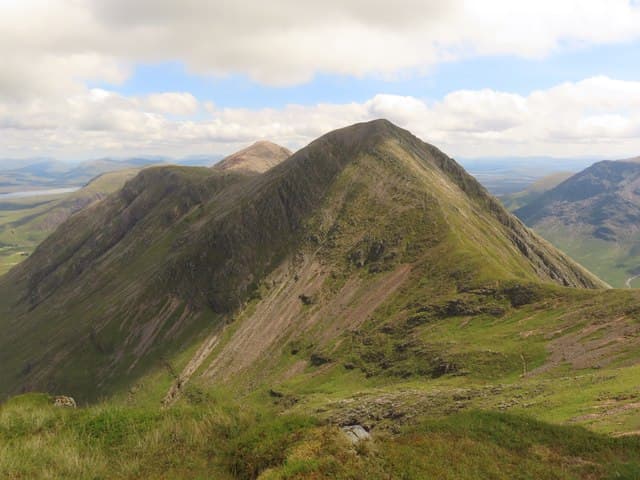
Stob na Doire
Stob na Doire — the peak of the grove — is the 1010m central top of the Buachaille Etive Mor ridge in upper Glen Etive at NN 207 532. Although overshadowed by Stob Dearg at the north-east end, it is the most graceful of the four tops on the Buachaille's long crest. The summit gives a remarkable view down the full sweep of Glen Etive to Loch Etive.
Quick facts
- Height
- 1010.5m/ 3315ft
- Prominence
- 144 m
- Grid ref
- NN 20759 53261
- Nearest city
- Fort William· 23km
- Dogs
- Dogs on lead required near livestockDog-friendly guide ↗
Sub-Marilyn: 144m of drop — misses the 150m Marilyn cut by 6m. We keep it on the list as a near-miss.
Height and prominence cross-checked against the Database of British and Irish Hills (CC BY).
No GPX track yet
Walked this route? Share your track to help other walkers.
Standard route
heather and bog 65% · grass slopes 25% · rocky summit 10%
The hill is usually traversed as part of the Buachaille Etive Mor ridge walk from Altnafeadh in Glen Coe. Approach by the Coire na Tulaich path to Stob Dearg, then follow the ridge south-west over Stob na Doire to the cairn — exposed scrambling on the descent west to the Bealach Fhaolain.
Terrain
Rocky ridge with sections of grade 1 scrambling between the tops, narrow in places with significant drops on either side. Mostly bare rock and gravel on the crest; the descent steps west from Stob na Doire are loose.
In winter
A full winter mountaineering objective: the Buachaille ridge demands axe, crampons and the ability to move efficiently on snow-covered rock. Cornices form on the east lip. Treat as a serious alpine-style day below 700m freezing levels.
This hill is in the Glen Coe SAIS forecast area. Check SAIS forecasts in winter (December–April).
Best time of year
Getting there
- Glasgow3h 39m
- Edinburgh5h 49m
OS maps: OS Landranger 41, OS Explorer 384
Mobile signal: Poor. Signal completely absent; a GPS tracker is advised for this remote hill.
Current conditions
Daylight Today
- Sunrise
- 05:16
- Sunset
- 21:36
- Civil dawn
- 04:25
- Civil dusk
- 22:27
NOAA Solar Calculator · 30 July 2026
Around Stob na Doire on the SCOT network
Getting there, basing yourself, and what to do off the hill.
Getting there: Bridge of Orchy station
Black Mount; Beinn Dorain, Beinn an Dothaidh, Beinn Achaladair, Beinn a Chreachain
16km from the hill
tripscot.co.uk
On TripSCOTBase yourself in Fort William
Ben Nevis base, West Highland Line, gateway to Lochaber
23km from the hill
tripscot.co.uk
On TasteSCOTAfter the hill: Ben Nevis Distillery
Fort William — Lochaber distillery at the foot of the Ben; long-aged Japanese-owned classics
24km from the hill
tastescot.co.uk
Stob na Doire — common questions
- How difficult is Stob na Doire?
- Stob na Doire carries a 3/5 (moderately challenging) grade on the OutdoorSCOT scale. Underfoot: Rocky ridge with sections of grade 1 scrambling between the tops, narrow in places with significant drops on either side.
- What is Stob na Doire's prominence?
- 144m of prominence. That's the vertical drop from the summit to the col that links Stob na Doire to the next higher ground. That leaves it 6m short of the 150m drop a Marilyn needs — DoBIH classes it a sub-Marilyn, a near-miss rather than a full Marilyn.
- When is the best time to climb Stob na Doire?
- April, May, June, September give the most reliable conditions on Stob na Doire. Beyond that window the high ground turns wintry: carry full mountain kit, be confident navigating, and check the SAIS avalanche forecast for the area.
- Is Stob na Doire dog-friendly?
- Yes, but dogs must be kept on a lead — there is livestock or ground-nesting bird interest on the route.
- Is there mobile signal on Stob na Doire?
- Poor. Signal completely absent; a GPS tracker is advised for this remote hill.
- Is Stob na Doire safe in winter?
- A full winter mountaineering objective: the Buachaille ridge demands axe, crampons and the ability to move efficiently on snow-covered rock. Cornices form on the east lip. Treat as a serious alpine-style day below 700m freezing levels.
Get the OutdoorSCOT weekly
One email a week — new route, hill and bothy guides, seasonal conditions and the odd hard-won lesson. No spam, unsubscribe in one click.