Marilyn · Glen Coe & Lochaber
An Grianan
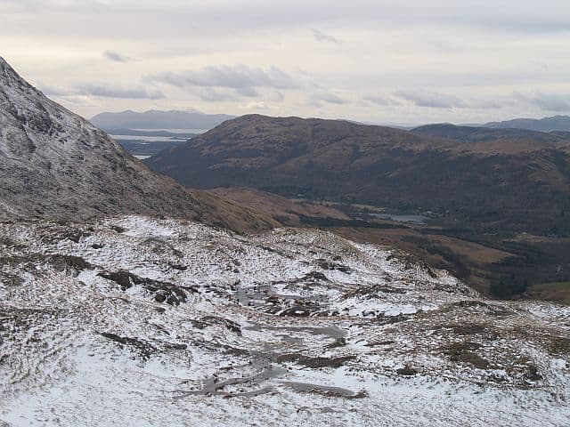
An Grianan — the sunny place — is a 549m hill on the south side of upper Glen Etive at NN 075 478. Like other "grianan" tops in the Highlands the name implies an east- or south-facing aspect favoured for shielings. From the cairn the long arm of Loch Etive stretches south-west towards Bonawe and the Connel narrows.
Quick facts
- Height
- 549m/ 1801ft
- Prominence
- 179 m
- Grid ref
- NN 07516 47822
- Nearest city
- Fort William· 26km
- Dogs
- Dogs on lead required near livestockDog-friendly guide ↗
Height and prominence cross-checked against the Database of British and Irish Hills (CC BY).
No GPX track yet
Walked this route? Share your track to help other walkers.
Standard route
heather moorland 60% · grass slopes 30% · rocky summit 10%
From the Glen Etive road near Coileitir, cross the river at the public bridge and climb the long south-east ridge through bracken and birch onto open hill. There is no continuous path; route-find around small crag bands to reach the summit.
Terrain
Atlantic oakwood and bracken on the lower hill, then heather, blaeberry and small crag bands on the ridge. The summit is a windswept patch of close-cropped grass with one weather-bleached cairn.
In winter
A west-facing ridge that catches plenty of low cloud and rain; snow rarely lasts long below 500m but the upper crags ice up quickly. The Glen Etive road can be impassable to ordinary cars after a major snowfall — check before driving in.
This hill is in the Glen Coe SAIS forecast area. Check SAIS forecasts in winter (December–April).
Best time of year
Getting there
- Glasgow3h 57m
- Edinburgh5h 17m
OS maps: OS Landranger 50, OS Explorer 384
Mobile signal: Patchy. EE fitful up top; better toward Loch Etive.
Current conditions
Daylight Today
- Sunrise
- 05:17
- Sunset
- 21:37
- Civil dawn
- 04:26
- Civil dusk
- 22:28
NOAA Solar Calculator · 30 July 2026
Around An Grianan on the SCOT network
Getting there, basing yourself, and what to do off the hill.
Getting there: Loch Awe station
East shore Loch Awe; Ben Cruachan; Kilchurn Castle
21km from the hill
tripscot.co.uk
On TripSCOTBase yourself in Fort William
Ben Nevis base, West Highland Line, gateway to Lochaber
26km from the hill
tripscot.co.uk
On TasteSCOTAfter the hill: Oban
Oban town centre — tiny two-still distillery bridging Highland and West Coast styles
28km from the hill
tastescot.co.uk
An Grianan — common questions
- How difficult is An Grianan?
- An Grianan carries a 2/5 (moderate) grade on the OutdoorSCOT scale. Ground conditions: Atlantic oakwood and bracken on the lower hill, then heather, blaeberry and small crag bands on the ridge.
- How much drop does An Grianan have?
- The drop is 179m: measured from the summit of An Grianan down to the saddle joining it to higher terrain. Passing the 150m-drop threshold on all sides is exactly what makes it a Marilyn.
- What's the best month to climb An Grianan?
- Aim for March, April, May, June, July, August, September, October on An Grianan. In the remaining months treat it as a winter hill — full kit, solid navigation, and a look at the relevant SAIS avalanche forecast before you go.
- Can dogs go up An Grianan?
- Dogs are fine on a lead. The route passes livestock or ground-nesting bird habitat, so keep them close throughout.
- Will I get phone signal on An Grianan?
- Patchy. EE fitful up top; better toward Loch Etive.
- Is An Grianan safe in winter?
- A west-facing ridge that catches plenty of low cloud and rain; snow rarely lasts long below 500m but the upper crags ice up quickly. The Glen Etive road can be impassable to ordinary cars after a major snowfall — check before driving in.
Get the OutdoorSCOT weekly
One email a week — new route, hill and bothy guides, seasonal conditions and the odd hard-won lesson. No spam, unsubscribe in one click.