Sub-Marilyn · Glen Coe & Lochaber
Meall Ban
Meall Ban — the fair-coloured rounded hill — is a 654m summit on the Benderloch peninsula at NM 996 498, between Loch Creran and Loch Etive. The pale quartz that breaks the summit slopes gives the hill its Gaelic name. From the cairn the Firth of Lorn stretches west to Mull and the Lismore lighthouse.
Gaelic: “rounded hill, fair” · Pronunciation: myowl bahn
Quick facts
- Height
- 654m/ 2146ft
- Prominence
- 145 m
- Grid ref
- NM 99658 49867
- Nearest city
- Oban· 24km
- Dogs
- Dogs on lead required near livestockDog-friendly guide ↗
Sub-Marilyn: 145m of drop — misses the 150m Marilyn cut by 5m. We keep it on the list as a near-miss.
Height and prominence cross-checked against the Database of British and Irish Hills (CC BY).
No GPX track yet
Walked this route? Share your track to help other walkers.
Standard route
heather moorland 65% · grass slopes 25% · rocky summit 10%
Begin at the small lay-by near Barcaldine Forest north of the A828, follow the forestry road up to the high col, then strike east onto open hill and climb a faint quad trace to the rocky summit dome.
Terrain
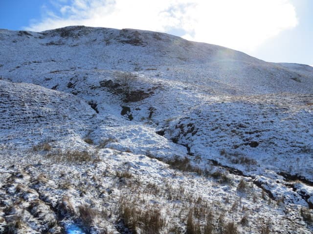
Sitka spruce and gravel forest road on the lower hill, then open moor of deer-grass and broken quartz outcrops. The summit area is wind-pruned grass with scattered white stones.
In winter
A west-coast hill where snowfall is mostly wet and ephemeral; the quartz outcrops can become slick after a freeze-thaw. Verglas on the rocks is the main risk; carry crampons only on a true Arctic spell.
This hill is in the Glen Coe SAIS forecast area. Check SAIS forecasts in winter (December–April).
Best time of year
Getting there
- Glasgow3h 15m
- Edinburgh6h 37m
OS maps: OS Landranger 49, OS Explorer 376, OS Explorer 384
Mobile signal: Poor. Nothing dependable; EE gives out in remote Breadalbane glens.
Current conditions
Daylight Today
- Sunrise
- 05:18
- Sunset
- 21:37
- Civil dawn
- 04:27
- Civil dusk
- 22:28
NOAA Solar Calculator · 30 July 2026
Around Meall Ban on the SCOT network
Getting there, basing yourself, and what to do off the hill.
Getting there: Oban station
Argyll ferry hub; Mull, Lismore, Coll, Tiree, Barra connections
24km from the hill
tripscot.co.uk
On TripSCOTBase yourself in Oban
Argyll ferry hub — Mull, Lismore, Coll, Tiree, Barra
24km from the hill
tripscot.co.uk
On TasteSCOTAfter the hill: Oban
Oban town centre — tiny two-still distillery bridging Highland and West Coast styles
24km from the hill
tastescot.co.uk
Meall Ban — common questions
- Is Meall Ban a hard climb?
- Meall Ban is rated 2/5 (moderate) on the OutdoorSCOT scale. Underfoot: Sitka spruce and gravel forest road on the lower hill, then open moor of deer-grass and broken quartz outcrops.
- What is Meall Ban's prominence?
- 145m of prominence. That's the vertical drop from the summit to the col that links Meall Ban to the next higher ground. That leaves it 5m short of the 150m drop a Marilyn needs — DoBIH classes it a sub-Marilyn, a near-miss rather than a full Marilyn.
- When is the best time to climb Meall Ban?
- March, April, May, June, July, August, September, October give the most reliable conditions on Meall Ban. Beyond that window the high ground turns wintry: carry full mountain kit, be confident navigating, and check the SAIS avalanche forecast for the area.
- Is Meall Ban dog-friendly?
- Yes, but dogs must be kept on a lead — there is livestock or ground-nesting bird interest on the route.
- Is there mobile signal on Meall Ban?
- Poor. Nothing dependable; EE gives out in remote Breadalbane glens.
- Is Meall Ban safe in winter?
- A west-coast hill where snowfall is mostly wet and ephemeral; the quartz outcrops can become slick after a freeze-thaw. Verglas on the rocks is the main risk; carry crampons only on a true Arctic spell.
Get the OutdoorSCOT weekly
One email a week — new route, hill and bothy guides, seasonal conditions and the odd hard-won lesson. No spam, unsubscribe in one click.