Sub-Marilyn · Glen Coe & Lochaber
Meall na Duibhe
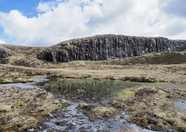
Meall na Duibhe — the dark-coloured top — is a 571m Marilyn in NN-square Lochaber, lying west of Loch Treig above the Lairig Leacach pass. The summit gathers views east across the loch to Stob Coire Easain and north toward the Grey Corries skyline.
Gaelic: “rounded hill, of the, black” · Pronunciation: myowl na doo-ya
Quick facts
- Height
- 571.4m/ 1875ft
- Prominence
- 149 m
- Grid ref
- NN 22654 62313
- Nearest city
- Fort William· 17km
- Dogs
- Dogs on lead required near livestockDog-friendly guide ↗
Sub-Marilyn: 149m of drop — misses the 150m Marilyn cut by 1m. We keep it on the list as a near-miss.
Height and prominence cross-checked against the Database of British and Irish Hills (CC BY).
No GPX track yet
Walked this route? Share your track to help other walkers.
Standard route
heather moorland 65% · grass slopes 25% · rocky summit 10%
Most parties walk in from the Corriechoille road end above Spean Bridge, taking the old Lairig Leacach stalking path south past the bothy before breaking out west across the burn onto the hill's open east flank. There is no path on the upper slope, just rough grass to the cairn.
Terrain
Built stalkers track for the first few kilometres of the Lairig Leacach, then pathless heather and crowberry over loose schist. The Allt Leachdach can run hard after rain — cross at the bothy rather than higher up.
In winter
A respectable 571m hill close enough to the Lochaber Munros to share their weather. Cornices form on the east shoulder above the lairig; the summit dome is windscoured but the descent line can hold deep windslab in places.
This hill is in the Glen Coe SAIS forecast area. Check SAIS forecasts in winter (December–April).
Best time of year
Getting there
- Glasgow3h 47m
- Edinburgh5h 51m
OS maps: OS Landranger 41, OS Explorer 384, OS Explorer 392
Mobile signal: Poor. A blanket dead zone on this Breadalbane summit.
Current conditions
Daylight Today
- Sunrise
- 05:16
- Sunset
- 21:37
- Civil dawn
- 04:24
- Civil dusk
- 22:28
NOAA Solar Calculator · 30 July 2026
Around Meall na Duibhe on the SCOT network
Getting there, basing yourself, and what to do off the hill.
Getting there: Corrour station
Highest mainline station; Loch Ossian, Ben Alder, Aonach Beag (Alder)
14km from the hill
tripscot.co.uk
On TripSCOTBase yourself in Fort William
Ben Nevis base, West Highland Line, gateway to Lochaber
17km from the hill
tripscot.co.uk
On TasteSCOTAfter the hill: Ben Nevis Distillery
Fort William — Lochaber distillery at the foot of the Ben; long-aged Japanese-owned classics
17km from the hill
tastescot.co.uk
Meall na Duibhe — common questions
- How hard is Meall na Duibhe?
- We grade Meall na Duibhe at 2/5, which puts it in moderate territory. Terrain: Built stalkers track for the first few kilometres of the Lairig Leacach, then pathless heather and crowberry over loose schist.
- How prominent is Meall na Duibhe?
- Meall na Duibhe has 149m of topographic prominence — the height of its summit above the highest col connecting it to higher ground. That leaves it 1m short of the 150m drop a Marilyn needs — DoBIH classes it a sub-Marilyn, a near-miss rather than a full Marilyn.
- When should I climb Meall na Duibhe?
- The standard good-weather months for Meall na Duibhe are March, April, May, June, July, August, September, October. Outside those months, expect winter conditions on the high ground — full mountain kit, navigation skills, and a check of the SAIS avalanche forecast for the relevant region.
- Can I bring my dog up Meall na Duibhe?
- On a lead only — the route crosses ground with livestock or nesting-bird interest.
- What's mobile reception like on Meall na Duibhe?
- Poor. A blanket dead zone on this Breadalbane summit.
- Is Meall na Duibhe safe in winter?
- A respectable 571m hill close enough to the Lochaber Munros to share their weather. Cornices form on the east shoulder above the lairig; the summit dome is windscoured but the descent line can hold deep windslab in places.
Get the OutdoorSCOT weekly
One email a week — new route, hill and bothy guides, seasonal conditions and the odd hard-won lesson. No spam, unsubscribe in one click.