Marilyn · Glen Coe & Lochaber
Meall Mor
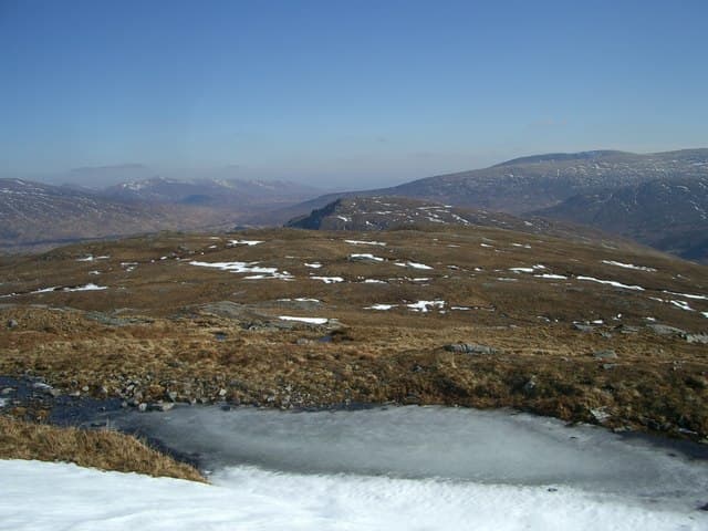
This Meall Mor is a 721m Marilyn in NN-square Lochaber, set on the watershed between Loch Ossian and the upper Spean a few kilometres north-west of Corrour station. The summit is one of the lonelier tops in central Scotland, looking out to the Aonachs in the west and the Grey Corries to the north.
Gaelic: “rounded hill, big” · Pronunciation: myowl more
Quick facts
- Height
- 721m/ 2365ft
- Grid ref
- NN 28057 70547
- Nearest city
- Fort William· 18km
- Dogs
- Dogs on lead required near livestockDog-friendly guide ↗
No GPX track yet
Walked this route? Share your track to help other walkers.
Standard route
blanket bog 50% · heather moorland 35% · grassy summit 15%
The classic line is the train approach from Glasgow to Corrour station, then a long walk west past Loch Ossian along the south shore before turning north onto the hill. There is no path of any kind on the slope itself; the route is map-and-compass work over peat hags and short heather.
Terrain
A textbook stretch of central-Highland blanket bog with cotton grass, sphagnum and stranded hags — the kind that swallow a boot whole in a wet spring. The upper dome is firmer ground of bilberry and gravel.
In winter
Above 700m the hill catches genuine winter weather and the bogs freeze into ankle-grabbing trenches under thin snow. The train access window is the main planning constraint; missed return services mean a night out.
This hill is in the Glen Coe SAIS forecast area. Check SAIS forecasts in winter (December–April).
Best time of year
Getting there
- Glasgow3h 49m
- Edinburgh5h 44m
OS maps: OS Landranger 41, OS Explorer 385W, OS Explorer 392
Mobile signal: Poor. Remote Lochaber/Rannoch area; very limited coverage.
Current conditions
Daylight Today
- Sunrise
- 04:28
- Sunset
- 22:16
- Civil dawn
- 03:22
- Civil dusk
- 23:23
NOAA Solar Calculator · 27 June 2026
Around Meall Mor on the SCOT network
Getting there, basing yourself, and what to do off the hill.
Getting there: Corrour station
Highest mainline station; Loch Ossian, Ben Alder, Aonach Beag (Alder)
9km from the hill
tripscot.co.uk
On TripSCOTBase yourself in Fort William
Ben Nevis base, West Highland Line, gateway to Lochaber
18km from the hill
tripscot.co.uk
On TasteSCOTAfter the hill: Ben Nevis Distillery
Fort William — Lochaber distillery at the foot of the Ben; long-aged Japanese-owned classics
17km from the hill
tastescot.co.uk
Meall Mor — common questions
- How hard is Meall Mor?
- Meall Mor is rated 2/5 (moderate) on the OutdoorSCOT scale. Terrain: A textbook stretch of central-Highland blanket bog with cotton grass, sphagnum and stranded hags — the kind that swallow a boot whole in a wet spring.
- When is the best time to climb Meall Mor?
- The standard good-weather months for Meall Mor are April, May, June, September. Outside those months, expect winter conditions on the high ground — full mountain kit, navigation skills, and a check of the SAIS avalanche forecast for the relevant region.
- Can I bring my dog up Meall Mor?
- Yes, but dogs must be kept on a lead — there is livestock or ground-nesting bird interest on the route.
- Is there mobile signal on Meall Mor?
- Poor. Remote Lochaber/Rannoch area; very limited coverage.
- Is Meall Mor safe in winter?
- Above 700m the hill catches genuine winter weather and the bogs freeze into ankle-grabbing trenches under thin snow. The train access window is the main planning constraint; missed return services mean a night out.
Get the OutdoorSCOT weekly
One email a week — new route, hill and bothy guides, seasonal conditions and the odd hard-won lesson. No spam, unsubscribe in one click.