Sub-Marilyn · Glen Coe & Lochaber
Meall an t-Suidhe
Meall an t-Suidhe — the seat-shaped hill — is a 711m Marilyn in NN-square Lochaber, the broad spur immediately north-west of Ben Nevis above the village of Achintee. Despite living in the giant's shadow, the top gives a superlative view of Nevis's northern cliffs and the Carn Mor Dearg arete.
Quick facts
- Height
- 711m/ 2333ft
- Prominence
- 146 m
- Grid ref
- NN 13943 72985
- Nearest city
- Fort William· 3km
- Dogs
- Dogs on lead required near livestockDog-friendly guide ↗
Sub-Marilyn: 146m of drop — misses the 150m Marilyn cut by 4m. We keep it on the list as a near-miss.
Height and prominence cross-checked against the Database of British and Irish Hills (CC BY).
No GPX track yet
Walked this route? Share your track to help other walkers.
Standard route
mountain path 40% · grass slopes 35% · rocky hillside 25%
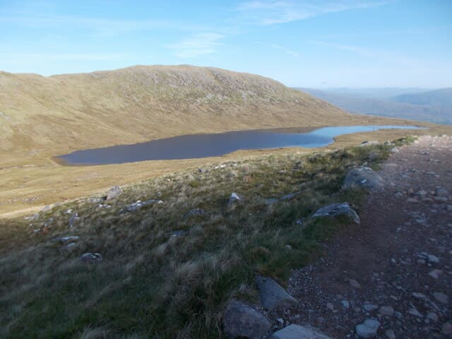
Follow the Ben Nevis mountain track from the Glen Nevis visitor centre as far as the "halfway lochan" (Lochan Meall an t-Suidhe), then leave the path and contour west-north-west onto open grass, climbing the gentle dome to a wee cairn. Many parties combine the diversion with a Ben Nevis ascent.
Terrain
Made path with stone-pitched stairs as far as the lochan, then short cropped grass and patches of bilberry on the broad spur. The slope above the lochan is gentle and dry compared with the main Ben Nevis track.
In winter
Cornices form on the eastern edge above the lochan; the dome itself is generally windswept but can ice up. Crampons and axe are essential in full winter conditions — the proximity of the busy Ben Nevis track sometimes deceives walkers into under-equipping.
This hill is in the Glen Coe SAIS forecast area. Check SAIS forecasts in winter (December–April).
Best time of year
Getting there
- Glasgow3h 13m
- Edinburgh5h 18m
OS maps: OS Landranger 41, OS Explorer 392
Mobile signal: Decent up top; EE works well. The sitting hill beside Ben Nevis — great views.
Current conditions
Daylight Today
- Sunrise
- 05:16
- Sunset
- 21:38
- Civil dawn
- 04:24
- Civil dusk
- 22:29
NOAA Solar Calculator · 30 July 2026
Around Meall an t-Suidhe on the SCOT network
Getting there, basing yourself, and what to do off the hill.
Base yourself in Fort William
Ben Nevis base, West Highland Line, gateway to Lochaber
3km from the hill
tripscot.co.uk
On TasteSCOTAfter the hill: Ben Nevis Distillery
Fort William — Lochaber distillery at the foot of the Ben; long-aged Japanese-owned classics
4km from the hill
tastescot.co.uk
Meall an t-Suidhe — common questions
- How hard is Meall an t-Suidhe?
- We grade Meall an t-Suidhe at 2/5, which puts it in moderate territory. Ground conditions: Made path with stone-pitched stairs as far as the lochan, then short cropped grass and patches of bilberry on the broad spur.
- How much drop does Meall an t-Suidhe have?
- The drop is 146m: measured from the summit of Meall an t-Suidhe down to the saddle joining it to higher terrain. That leaves it 4m short of the 150m drop a Marilyn needs — DoBIH classes it a sub-Marilyn, a near-miss rather than a full Marilyn.
- What's the best month to climb Meall an t-Suidhe?
- Aim for April, May, June, September on Meall an t-Suidhe. In the remaining months treat it as a winter hill — full kit, solid navigation, and a look at the relevant SAIS avalanche forecast before you go.
- Can dogs go up Meall an t-Suidhe?
- Dogs are fine on a lead. The route passes livestock or ground-nesting bird habitat, so keep them close throughout.
- Will I get phone signal on Meall an t-Suidhe?
- Decent up top; EE works well. The sitting hill beside Ben Nevis — great views.
- Is Meall an t-Suidhe safe in winter?
- Cornices form on the eastern edge above the lochan; the dome itself is generally windswept but can ice up. Crampons and axe are essential in full winter conditions — the proximity of the busy Ben Nevis track sometimes deceives walkers into under-equipping.
Get the OutdoorSCOT weekly
One email a week — new route, hill and bothy guides, seasonal conditions and the odd hard-won lesson. No spam, unsubscribe in one click.