Marilyn · Glen Coe & Lochaber
Meall an t-Slamain
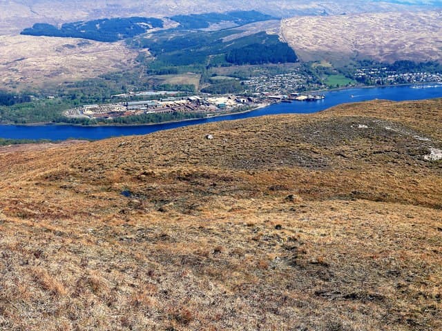
Meall an t-Slamain rises directly above the Corran Ferry on the west shore of Loch Linnhe, a 467m hill that gives one of the most accessible summit views in Ardgour. The Gaelic name relates to slippery or marshy ground. The reward at the top is a remarkable panorama: Ben Nevis dominates to the north, the Mamores fill the east, and Loch Linnhe stretches away south.
Quick facts
- Height
- 467m/ 1532ft
- Prominence
- 200 m
- Grid ref
- NN 07105 73934
- Nearest city
- Fort William· 3km
- Dogs
- Dogs on lead required near livestockDog-friendly guide ↗
Height and prominence cross-checked against the Database of British and Irish Hills (CC BY).
No GPX track yet
Walked this route? Share your track to help other walkers.
Standard route
heather and bog 60% · rocky slopes 25% · grass slopes 15%
From the Ardgour side of the Corran Ferry, follow the lane south to the forest edge, then climb open hillside west to gain the broad ridge. The summit cairn is unmistakable. A relaxed half-day at two to three hours return.
Terrain
Boggy heathery ground throughout — true to the hill's name. Some forestry to negotiate at the start. The summit ridge itself is firmer, with short turf and scattered rocks.
In winter
Low altitude means snow rarely lingers, but the wet ground freezes into hard hummocks that need care. Useful as a winter-day starter when nearby Glencoe and the Mamores are out of condition.
This hill is in the Glen Coe SAIS forecast area. Check SAIS forecasts in winter (December–April).
Best time of year
Getting there
- Glasgow3h 25m
- Edinburgh6h 34m
OS maps: OS Landranger 41, OS Explorer 391, OS Explorer 392
Mobile signal: Poor. No coverage start to finish; remote Ardgour glen has no infrastructure.
Current conditions
Daylight Today
- Sunrise
- 05:16
- Sunset
- 21:38
- Civil dawn
- 04:25
- Civil dusk
- 22:30
NOAA Solar Calculator · 30 July 2026
Around Meall an t-Slamain on the SCOT network
Getting there, basing yourself, and what to do off the hill.
Base yourself in Fort William
Ben Nevis base, West Highland Line, gateway to Lochaber
3km from the hill
tripscot.co.uk
On TasteSCOTAfter the hill: Ben Nevis Distillery
Fort William — Lochaber distillery at the foot of the Ben; long-aged Japanese-owned classics
6km from the hill
tastescot.co.uk
Meall an t-Slamain — common questions
- How difficult is Meall an t-Slamain?
- Meall an t-Slamain carries a 1/5 (easy) grade on the OutdoorSCOT scale. Underfoot: Boggy heathery ground throughout — true to the hill's name.
- What is Meall an t-Slamain's prominence?
- 200m of prominence. That's the vertical drop from the summit to the col that links Meall an t-Slamain to the next higher ground. That drop is what qualifies it as a Marilyn — a hill with at least 150m of descent on every side.
- When is the best time to climb Meall an t-Slamain?
- March, April, May, June, July, August, September, October give the most reliable conditions on Meall an t-Slamain. Beyond that window the high ground turns wintry: carry full mountain kit, be confident navigating, and check the SAIS avalanche forecast for the area.
- Is Meall an t-Slamain dog-friendly?
- Yes, but dogs must be kept on a lead — there is livestock or ground-nesting bird interest on the route.
- Is there mobile signal on Meall an t-Slamain?
- Poor. No coverage start to finish; remote Ardgour glen has no infrastructure.
- Is Meall an t-Slamain safe in winter?
- Low altitude means snow rarely lingers, but the wet ground freezes into hard hummocks that need care. Useful as a winter-day starter when nearby Glencoe and the Mamores are out of condition.
Get the OutdoorSCOT weekly
One email a week — new route, hill and bothy guides, seasonal conditions and the odd hard-won lesson. No spam, unsubscribe in one click.