Marilyn · Glen Coe & Lochaber
Doire Ban
Doire Ban — the fair-coloured grove — is a 566m Marilyn in NN-square Lochaber, set on the steep ground above the south shore of Loch Arkaig west of Achnacarry. The summit looks down into the wooded narrows of Mile Dorcha (the Dark Mile) and across to the Locheil Forest on the far side of the loch.
Gaelic: “fair” · Pronunciation: doire bahn
Quick facts
- Height
- 566m/ 1857ft
- Prominence
- 161 m
- Grid ref
- NN 09058 64370
- Nearest city
- Fort William· 10km
- Dogs
- Dogs on lead required near livestockDog-friendly guide ↗
Height and prominence cross-checked against the Database of British and Irish Hills (CC BY).
No GPX track yet
Walked this route? Share your track to help other walkers.
Standard route
heather and bog 65% · grass slopes 25% · rocky summit 10%
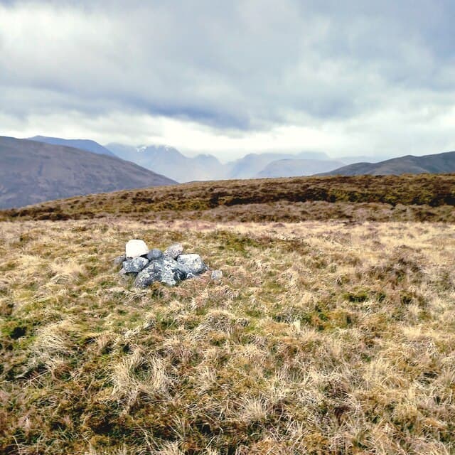
Most walkers start from the lay-bys along the B8005 between Bunarkaig and Clunes, climbing through old oak and birch (the doire of the name) onto a rough hillside above the lochside road. The upper slope is pathless tussock and outcrop with a small cairn perched on a knoll of bare schist.
Terrain
Steep wooded approach through oak and birch with hazel coppice and bracken low down. Above the treeline the slope is short heather, mossy outcrop and patches of bare rock — wet under the canopy after rain.
In winter
A sheltered Atlantic hill that holds snow only in genuinely cold spells. The main winter danger is wind-thrown trees blocking the lochside road; check before driving in. Microspikes useful for icy bracken on the descent.
This hill is in the Glen Coe SAIS forecast area. Check SAIS forecasts in winter (December–April).
Best time of year
Getting there
- Glasgow3h 11m
- Edinburgh5h 24m
OS maps: OS Landranger 41, OS Explorer 392
Mobile signal: Very poor. No mobile coverage; personal locator beacon recommended.
Current conditions
Daylight Today
- Sunrise
- 05:16
- Sunset
- 21:38
- Civil dawn
- 04:25
- Civil dusk
- 22:29
NOAA Solar Calculator · 30 July 2026
Around Doire Ban on the SCOT network
Getting there, basing yourself, and what to do off the hill.
Getting there: Fort William station
Ben Nevis, Mamores, Aonachs, Knoydart ferry connection
10km from the hill
tripscot.co.uk
On TripSCOTBase yourself in Fort William
Ben Nevis base, West Highland Line, gateway to Lochaber
10km from the hill
tripscot.co.uk
On TasteSCOTAfter the hill: Ben Nevis Distillery
Fort William — Lochaber distillery at the foot of the Ben; long-aged Japanese-owned classics
12km from the hill
tastescot.co.uk
Doire Ban — common questions
- How hard is Doire Ban?
- We grade Doire Ban at 2/5, which puts it in moderate territory. Ground conditions: Steep wooded approach through oak and birch with hazel coppice and bracken low down.
- How much drop does Doire Ban have?
- The drop is 161m: measured from the summit of Doire Ban down to the saddle joining it to higher terrain. Passing the 150m-drop threshold on all sides is exactly what makes it a Marilyn.
- What's the best month to climb Doire Ban?
- Aim for March, April, May, June, July, August, September, October on Doire Ban. In the remaining months treat it as a winter hill — full kit, solid navigation, and a look at the relevant SAIS avalanche forecast before you go.
- Can dogs go up Doire Ban?
- Dogs are fine on a lead. The route passes livestock or ground-nesting bird habitat, so keep them close throughout.
- Will I get phone signal on Doire Ban?
- Very poor. No mobile coverage; personal locator beacon recommended.
- Is Doire Ban safe in winter?
- A sheltered Atlantic hill that holds snow only in genuinely cold spells. The main winter danger is wind-thrown trees blocking the lochside road; check before driving in. Microspikes useful for icy bracken on the descent.
Get the OutdoorSCOT weekly
One email a week — new route, hill and bothy guides, seasonal conditions and the odd hard-won lesson. No spam, unsubscribe in one click.