Sub-Marilyn · Central Highlands
Cnoc Fraing
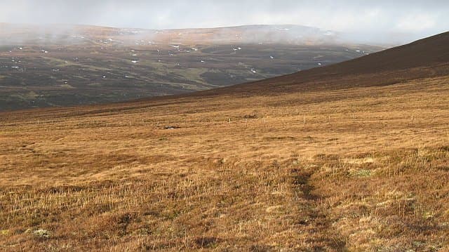
Cnoc Fraing translates roughly as the French hillock, an oddly cosmopolitan name for a 745m bulge of peat-hag and heather lost in the eastern Monadhliath above Strathdearn. It sits west of the A9 between Tomatin and Slochd, its summit a quiet vantage over the Findhorn headwaters and the empty country running south to the Cairngorms.
Quick facts
- Height
- 745.6m/ 2446ft
- Prominence
- 144 m
- Grid ref
- NH 80629 14378
- Nearest city
- Inverness· 34km
- Dogs
- Dogs on lead required near livestockDog-friendly guide ↗
Sub-Marilyn: 144m of drop — misses the 150m Marilyn cut by 6m. We keep it on the list as a near-miss.
Height and prominence cross-checked against the Database of British and Irish Hills (CC BY).
No GPX track yet
Walked this route? Share your track to help other walkers.
Standard route
heather moorland 65% · grass slopes 25% · rocky summit 10%
Most parties start from the dead-end road into Coignafearn or from a forestry track off the old A9 near Tomatin, then strike up across long peat ramps and tussock to a flat summit cairn. There is no path of any kind on the upper hill and the navigation in mist can be unexpectedly tricky given how featureless the plateau is. Allow 3 to 5 hours depending on start point.
Terrain
A classic eastern Monadhliath surface: deep peat groughs, knee-high heather and patches of cotton-grass bog that drain badly even in summer. The rock barely shows except in a few small breaks of granite gravel near the top. Gaiters and a willingness to weave around hags help.
In winter
At 745m the summit holds firm snow from December into April most years and the plateau wind-scours into hard slabs that can mask the deeper hags below. Whiteout navigation here is genuinely serious because there are no edges or burns to fix on. Microspikes for the icy peat in early winter, full axe and crampons once the cornicing builds along the eastern lip.
This hill is in the Creag Meagaidh SAIS forecast area. Check SAIS forecasts in winter (December–April).
Best time of year
Getting there
- Glasgow4h 33m
- Edinburgh4h 50m
OS maps: OS Landranger 35, OS Explorer 417
Mobile signal: Poor. No signal; nearest EE coverage near the coast or A835.
Current conditions
Daylight Today
- Sunrise
- 05:09
- Sunset
- 21:36
- Civil dawn
- 04:17
- Civil dusk
- 22:28
NOAA Solar Calculator · 30 July 2026
Around Cnoc Fraing on the SCOT network
Getting there, basing yourself, and what to do off the hill.
Getting there: Aviemore station
Cairngorm plateau; Lairig Ghru; Speyside Way; Glenmore
9km from the hill
tripscot.co.uk
On TripSCOTBase yourself in Aviemore
Cairngorms base — Strathspey valley, ski centre, train
9km from the hill
tripscot.co.uk
On TasteSCOTAfter the hill: Tomatin
Tomatin — large Highland distillery just off the A9, south of Inverness
16km from the hill
tastescot.co.uk
Cnoc Fraing — common questions
- How hard is Cnoc Fraing?
- We grade Cnoc Fraing at 2/5, which puts it in moderate territory. Terrain: A classic eastern Monadhliath surface: deep peat groughs, knee-high heather and patches of cotton-grass bog that drain badly even in summer.
- How prominent is Cnoc Fraing?
- Cnoc Fraing has 144m of topographic prominence — the height of its summit above the highest col connecting it to higher ground. That leaves it 6m short of the 150m drop a Marilyn needs — DoBIH classes it a sub-Marilyn, a near-miss rather than a full Marilyn.
- When should I climb Cnoc Fraing?
- The standard good-weather months for Cnoc Fraing are April, May, June, September. Outside those months, expect winter conditions on the high ground — full mountain kit, navigation skills, and a check of the SAIS avalanche forecast for the relevant region.
- Can I bring my dog up Cnoc Fraing?
- On a lead only — the route crosses ground with livestock or nesting-bird interest.
- What's mobile reception like on Cnoc Fraing?
- Poor. No signal; nearest EE coverage near the coast or A835.
- Is Cnoc Fraing safe in winter?
- At 745m the summit holds firm snow from December into April most years and the plateau wind-scours into hard slabs that can mask the deeper hags below. Whiteout navigation here is genuinely serious because there are no edges or burns to fix on. Microspikes for the icy peat in early winter, full axe and crampons once the cornicing builds along the eastern lip.
Get the OutdoorSCOT weekly
One email a week — new route, hill and bothy guides, seasonal conditions and the odd hard-won lesson. No spam, unsubscribe in one click.