Donald · Borders
Windlestraw Law
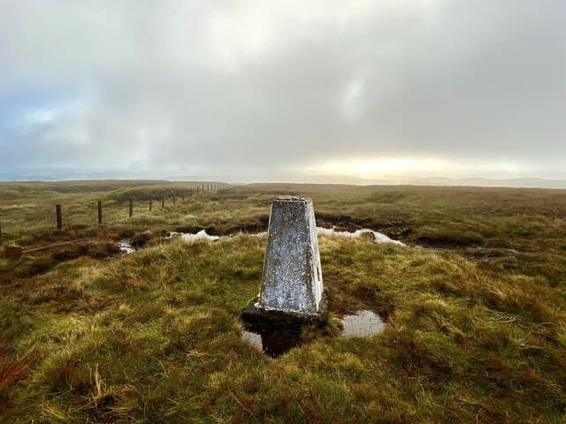
Windlestraw Law is the high point of the Moorfoot Hills — a great rolling stretch of moor between Innerleithen and the Edinburgh fringes. A fence-junction with a small cairn marks the top, set in a plain of bog cotton and short heather.
Quick facts
- Height
- 659.2m/ 2163ft
- Prominence
- 460 m
- Distance
- 13 km
- Ascent
- 540 m
- Time
- 3–6 hrs
- Grid ref
- NT371430
- Parking
- NT332368
- Nearest city
- Edinburgh· 33km
- Dogs
- Dogs on lead required near livestockDog-friendly guide ↗
Height and prominence cross-checked against the Database of British and Irish Hills (CC BY).
No GPX track yet
Walked this route? Share your track to help other walkers.
Standard route
grass moorland 80% · heather patches 15% · summit area 5%
The neatest approach climbs the south ridge from Innerleithen, gaining the watershed fence and following it east to the cairn. About 12km return with 540m of climb.
Terrain
Peaty top with hidden runnels — slow going in the wet. The watershed fence runs all the way across the plateau and is essential navigation in cloud.
In winter
Drifts heap against the watershed fence in westerlies; in easterlies the top scours bare. Modest height but real exposure on the plateau.
Best time of year
Getting there
- Glasgow2h 43m
- Edinburgh1h 47m
OS maps: OS Landranger 73
Mobile signal: Solid summit coverage; EE is dependable. Clear views across the Moorfoot Hills.
Current conditions
Daylight Today
- Sunrise
- 04:52
- Sunset
- 21:45
- Civil dawn
- 03:58
- Civil dusk
- 22:39
NOAA Solar Calculator · 17 July 2026
On a long-distance route
Windlestraw Law sits within 5km of these named long-distance walks — useful for trail-pack rest days or section extensions.
Around Windlestraw Law on the SCOT network
Getting there, basing yourself, and what to do off the hill.
Windlestraw Law — common questions
- Is Windlestraw Law a hard climb?
- Windlestraw Law is rated 3/5 (moderately challenging) on the OutdoorSCOT scale. The standard route covers about 13km with 540m of ascent and takes most walkers 3-6 hours. Terrain: Peaty top with hidden runnels — slow going in the wet.
- How prominent is Windlestraw Law?
- Windlestraw Law has 460m of topographic prominence — the height of its summit above the highest col connecting it to higher ground.
- Where should I park to climb Windlestraw Law?
- Standard parking is at NT332368. Check the parking grid reference on an OS map before travel; informal laybys can fill on summer weekends.
- When should I climb Windlestraw Law?
- The standard good-weather months for Windlestraw Law are March, April, May, June, July, August, September, October, November. Outside those months, expect winter conditions on the high ground — full mountain kit, navigation skills, and a check of the SAIS avalanche forecast for the relevant region.
- Can I bring my dog up Windlestraw Law?
- On a lead only — the route crosses ground with livestock or nesting-bird interest.
- What's mobile reception like on Windlestraw Law?
- Solid summit coverage; EE is dependable. Clear views across the Moorfoot Hills.
- Is Windlestraw Law safe in winter?
- Drifts heap against the watershed fence in westerlies; in easterlies the top scours bare. Modest height but real exposure on the plateau.
Get the OutdoorSCOT weekly
One email a week — new route, hill and bothy guides, seasonal conditions and the odd hard-won lesson. No spam, unsubscribe in one click.