Donald · Borders
Bowbeat Hill
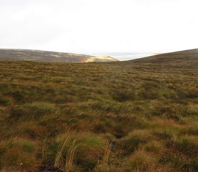
Bowbeat Hill (626m) is the highest point of the Moorfoots, a rolling heather plateau rising south of Edinburgh between Eddleston and Heriot. The summit is unmarked among the turbines of the Bowbeat Wind Farm — the first commercial windfarm in the Borders, commissioned in 2002. The hill's broad back is crossed by service roads that have transformed access since the turbines arrived.
Quick facts
- Height
- 626m/ 2054ft
- Prominence
- 78 m
- Distance
- 12 km
- Ascent
- 470 m
- Time
- 3–5 hrs
- Grid ref
- NT292469
- Parking
- NT303475
- Nearest city
- Edinburgh· 27km
- Dogs
- Dogs on lead required near livestockDog-friendly guide ↗
Height and prominence cross-checked against the Database of British and Irish Hills (CC BY).
No GPX track yet
Walked this route? Share your track to help other walkers.
Standard route
grass moorland 75% · heather patches 20% · summit area 5%
The simplest approach uses the Bowbeat wind-farm access track from Portmore Loch at NT253500, walked south-west to gain the plateau in roughly 12km return with 470m of ascent. The graded service road climbs steadily through felled forestry onto the heather moor and circles among the turbine bases. The true summit lies a short distance off the track in heather; a GPS helps to fix the exact spot.
Terrain
The wind-farm service road is hard-graded gravel and gives an unusually fast approach for a Moorfoot summit. Off the road the ground is deep heather and bog typical of the plateau, with the turbine bases acting as oversized cairns. Forestry clearance has changed the lower landscape — the OS map may be ahead of or behind the actual fell.
In winter
Bowbeat is fully exposed to easterly haar that rolls off the North Sea, freezing onto turbine blades and the rough heather alike. The service road clears quickly in mild weather but ices severely on shaded sections under hard frost. Falling ice from blades is a genuine seasonal hazard close to the turbine bases — keep a respectful distance after thaw events.
Best time of year
Getting there
- Glasgow2h 43m
- Edinburgh1h 39m
OS maps: OS Landranger 73
Mobile signal: Reliable up top; EE reliable. Fine Moorfoot Hills viewpoint.
Current conditions
Daylight Today
- Sunrise
- 04:46
- Sunset
- 21:50
- Civil dawn
- 03:50
- Civil dusk
- 22:46
NOAA Solar Calculator · 13 July 2026
Around Bowbeat Hill on the SCOT network
Getting there, basing yourself, and what to do off the hill.
Bowbeat Hill — common questions
- What difficulty is Bowbeat Hill?
- On the OutdoorSCOT scale, Bowbeat Hill comes in at 3/5 — moderately challenging. Expect roughly 12km and 470m of ascent on the usual route — 3-5 hours for most parties. Underfoot: The wind-farm service road is hard-graded gravel and gives an unusually fast approach for a Moorfoot summit.
- What is Bowbeat Hill's prominence?
- 78m of prominence. That's the vertical drop from the summit to the col that links Bowbeat Hill to the next higher ground.
- Where do I park for Bowbeat Hill?
- Most walkers start from NT303475. Verify the grid reference on an OS map before you set off — space is tight on busy summer weekends.
- When is the best time to climb Bowbeat Hill?
- March, April, May, June, July, August, September, October, November give the most reliable conditions on Bowbeat Hill. Beyond that window the high ground turns wintry: carry full mountain kit, be confident navigating, and check the SAIS avalanche forecast for the area.
- Is Bowbeat Hill dog-friendly?
- Yes, but dogs must be kept on a lead — there is livestock or ground-nesting bird interest on the route.
- Is there mobile signal on Bowbeat Hill?
- Reliable up top; EE reliable. Fine Moorfoot Hills viewpoint.
- Is Bowbeat Hill safe in winter?
- Bowbeat is fully exposed to easterly haar that rolls off the North Sea, freezing onto turbine blades and the rough heather alike. The service road clears quickly in mild weather but ices severely on shaded sections under hard frost. Falling ice from blades is a genuine seasonal hazard close to the turbine bases — keep a respectful distance after thaw events.
Get the OutdoorSCOT weekly
One email a week — new route, hill and bothy guides, seasonal conditions and the odd hard-won lesson. No spam, unsubscribe in one click.