Donald · Borders
Whitehope Law
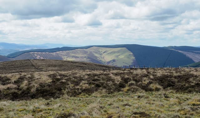
Whitehope Law (623m) sits deep in the eastern Moorfoots above the Heriot Water, a deep heather dome rising from the headwaters of the Gala. A small heap of stones beside the march fence marks the summit. The hill links to Bowbeat Hill along a broad watershed and sees few visitors outside the August grouse season — the high ground feels remote despite its proximity to Edinburgh.
Quick facts
- Height
- 623m/ 2044ft
- Prominence
- 66 m
- Distance
- 12 km
- Ascent
- 467 m
- Time
- 3–5 hrs
- Grid ref
- NT330445
- Parking
- NT332453
- Nearest city
- Edinburgh· 30km
- Dogs
- Dogs on lead required near livestockDog-friendly guide ↗
Height and prominence cross-checked against the Database of British and Irish Hills (CC BY).
No GPX track yet
Walked this route? Share your track to help other walkers.
Standard route
grass moorland 80% · heather patches 15% · summit area 5%
The most direct approach starts from Heriot at NT400535 and follows the estate track south up the Heriot Cleugh before climbing the broad north ridge. The walk runs roughly 12km with 467m of ascent. The estate track makes a steady walk-in and a march fence guides the final ascent. The summit cairn is small and easily missed if the fence is your only handrail.
Terrain
Deep heather characterises the upper slopes — leg-tiring in summer when the stems lock around boots, and a slow grind through patches of bog underneath. The march fence is well-maintained and serves as a continuous handrail across the plateau. Grouse butts and stone shooting markers provide secondary waypoints.
In winter
The Moorfoot heather flattens under snow into deceptively walkable slopes that hide bog holes and watercourses. Easterly haar can grey out the plateau for days, and the fence becomes more important than the map. Sub-zero conditions freeze the bog into solid ground — often the best time of year to cross this kind of moor.
Best time of year
Getting there
- Glasgow2h 49m
- Edinburgh1h 43m
OS maps: OS Landranger 73
Mobile signal: Strong summit reception; count on EE. Fine Tweeddale moorland viewpoint.
Current conditions
Daylight Today
- Sunrise
- 04:46
- Sunset
- 21:50
- Civil dawn
- 03:50
- Civil dusk
- 22:46
NOAA Solar Calculator · 13 July 2026
Around Whitehope Law on the SCOT network
Getting there, basing yourself, and what to do off the hill.
Whitehope Law — common questions
- What difficulty is Whitehope Law?
- On the OutdoorSCOT scale, Whitehope Law comes in at 3/5 — moderately challenging. Expect roughly 12km and 467m of ascent on the usual route — 3-5 hours for most parties. Ground conditions: Deep heather characterises the upper slopes — leg-tiring in summer when the stems lock around boots, and a slow grind through patches of bog underneath.
- How much drop does Whitehope Law have?
- The drop is 66m: measured from the summit of Whitehope Law down to the saddle joining it to higher terrain.
- Where's the parking for Whitehope Law?
- Park at NT332453. Double-check the grid reference on an OS map first; informal laybys here fill early in high season.
- What's the best month to climb Whitehope Law?
- Aim for March, April, May, June, July, August, September, October, November on Whitehope Law. In the remaining months treat it as a winter hill — full kit, solid navigation, and a look at the relevant SAIS avalanche forecast before you go.
- Can dogs go up Whitehope Law?
- Dogs are fine on a lead. The route passes livestock or ground-nesting bird habitat, so keep them close throughout.
- Will I get phone signal on Whitehope Law?
- Strong summit reception; count on EE. Fine Tweeddale moorland viewpoint.
- Is Whitehope Law safe in winter?
- The Moorfoot heather flattens under snow into deceptively walkable slopes that hide bog holes and watercourses. Easterly haar can grey out the plateau for days, and the fence becomes more important than the map. Sub-zero conditions freeze the bog into solid ground — often the best time of year to cross this kind of moor.
Get the OutdoorSCOT weekly
One email a week — new route, hill and bothy guides, seasonal conditions and the odd hard-won lesson. No spam, unsubscribe in one click.