Donald · Borders
Whitehope Heights
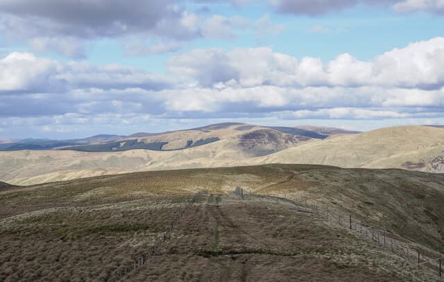
Whitehope Heights (637m) is a rolling top in the Tweedsmuir massif above the Devil's Beef Tub, looking down on the A701 watershed between the Tweed and Annan. A small cairn marks the highest point of a broad grassy crown that links Annanhead Hill and Great Hill in an obvious skyline. Few walkers visit for its own sake; most pass over on round trips taking in Hart Fell or Chalk Rig Edge.
Quick facts
- Height
- 637m/ 2090ft
- Prominence
- 109 m
- Distance
- 12 km
- Ascent
- 478 m
- Time
- 3–5 hrs
- Grid ref
- NT095139
- Parking
- NT103145
- Nearest city
- Dumfries· 40km
- Dogs
- Dogs on lead required near livestockDog-friendly guide ↗
Height and prominence cross-checked against the Database of British and Irish Hills (CC BY).
No GPX track yet
Walked this route? Share your track to help other walkers.
Standard route
grass moorland 80% · heather patches 15% · summit area 5%
Begin at the Devil's Beef Tub viewpoint on the A701 at NT060128 and follow the Annandale Way fence northwards over Annanhead Hill before drifting east onto Whitehope Heights — roughly 12km return with 478m of ascent. The going is on close-cropped sheep grass with shallow peat hags near the summit. The escarpment dropping into the Beef Tub itself is steep and undercut — keep clear of the edge in mist.
Terrain
Smooth grazed grass and short rush make this a comfortable walk underfoot, but the broad summit plateau has limited fix-points. The fence line from Annanhead is reliable; once away from it the going gets tussocky and rolling. The Beef Tub rim is the dominant terrain feature and a useful eastern handrail throughout.
In winter
The A701 watershed catches drifting snow that can plug the road for days, and Whitehope Heights sees this same weather first-hand. Cornices build along the steep Beef Tub headwall; verglas forms on the cropped grass after thaw–freeze cycles. SAIS Southern Uplands forecasts cover this ground when conditions warrant. Stick to the fence and stay back from the rim.
Best time of year
Getting there
- Glasgow2h 43m
- Edinburgh1h 29m
OS maps: OS Landranger 78
Mobile signal: Decent up top; EE behaves well. Smooth Tweeddale viewpoint.
Current conditions
Daylight Today
- Sunrise
- 04:55
- Sunset
- 21:45
- Civil dawn
- 04:02
- Civil dusk
- 22:38
NOAA Solar Calculator · 17 July 2026
Around Whitehope Heights on the SCOT network
Getting there, basing yourself, and what to do off the hill.
Whitehope Heights — common questions
- How difficult is Whitehope Heights?
- Whitehope Heights carries a 3/5 (moderately challenging) grade on the OutdoorSCOT scale. Count on about 12km, 478m of ascent and a 3-5 hour day on the standard route. Underfoot: Smooth grazed grass and short rush make this a comfortable walk underfoot, but the broad summit plateau has limited fix-points.
- What is Whitehope Heights's prominence?
- 109m of prominence. That's the vertical drop from the summit to the col that links Whitehope Heights to the next higher ground.
- Where do I park for Whitehope Heights?
- Most walkers start from NT103145. Verify the grid reference on an OS map before you set off — space is tight on busy summer weekends.
- When is the best time to climb Whitehope Heights?
- March, April, May, June, July, August, September, October, November give the most reliable conditions on Whitehope Heights. Beyond that window the high ground turns wintry: carry full mountain kit, be confident navigating, and check the SAIS avalanche forecast for the area.
- Is Whitehope Heights dog-friendly?
- Yes, but dogs must be kept on a lead — there is livestock or ground-nesting bird interest on the route.
- Is there mobile signal on Whitehope Heights?
- Decent up top; EE behaves well. Smooth Tweeddale viewpoint.
- Is Whitehope Heights safe in winter?
- The A701 watershed catches drifting snow that can plug the road for days, and Whitehope Heights sees this same weather first-hand. Cornices build along the steep Beef Tub headwall; verglas forms on the cropped grass after thaw–freeze cycles. SAIS Southern Uplands forecasts cover this ground when conditions warrant. Stick to the fence and stay back from the rim.
Get the OutdoorSCOT weekly
One email a week — new route, hill and bothy guides, seasonal conditions and the odd hard-won lesson. No spam, unsubscribe in one click.