Donald · Borders
Cape Law
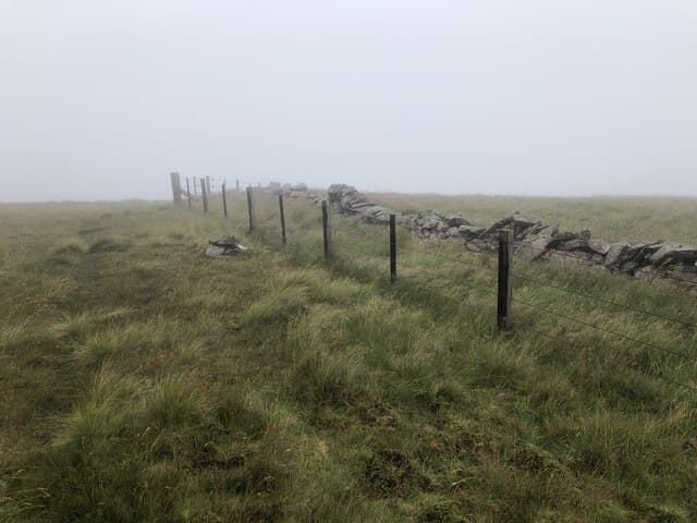
Cape Law links the Hart Fell massif to the Moffat watershed near Talla Reservoir, an angular fence corner at its top giving the only orientation point. The interior of the Moffats opens out from here in a long lonely panorama.
Quick facts
- Height
- 722m/ 2369ft
- Prominence
- 93 m
- Distance
- 13 km
- Ascent
- 592 m
- Time
- 3–6 hrs
- Grid ref
- NT131150
- Parking
- NT138134
- Nearest city
- Dumfries· 42km
- Dogs
- Dogs on lead required near livestockDog-friendly guide ↗
Height and prominence cross-checked against the Database of British and Irish Hills (CC BY).
No GPX track yet
Walked this route? Share your track to help other walkers.
Standard route
grass moorland 80% · heather patches 15% · summit area 5%
Walkers usually reach it from Hart Fell via Whitehope Knowe, or up the long shoulder from Talla Linnfoots. There are no paths — the fence line between the Borders and Dumfries does the navigating for you.
Terrain
Acid grassland on a flat, peat-laced summit. Some peat hags along the watershed but never deep. The fence is rebuilt in places with new posts; old stiles still cling to the wire here and there.
In winter
Sees plenty of snow showers but rarely deep cover; the watershed wind keeps the tops scoured. The combination of low cloud and easterly drift can put visibility down to a few yards on this dead-flat top.
Best time of year
Getting there
- Glasgow2h 45m
- Edinburgh1h 26m
OS maps: OS Landranger 78
Mobile signal: Reliable up top; count on EE. Pentland fringe viewpoint.
Current conditions
Daylight Today
- Sunrise
- 04:49
- Sunset
- 21:49
- Civil dawn
- 03:54
- Civil dusk
- 22:44
NOAA Solar Calculator · 13 July 2026
Around Cape Law on the SCOT network
Getting there, basing yourself, and what to do off the hill.
Cape Law — common questions
- How difficult is Cape Law?
- Cape Law carries a 3/5 (moderately challenging) grade on the OutdoorSCOT scale. Count on about 13km, 592m of ascent and a 3-6 hour day on the standard route. Ground conditions: Acid grassland on a flat, peat-laced summit.
- How much drop does Cape Law have?
- The drop is 93m: measured from the summit of Cape Law down to the saddle joining it to higher terrain.
- Where's the parking for Cape Law?
- Park at NT138134. Double-check the grid reference on an OS map first; informal laybys here fill early in high season.
- What's the best month to climb Cape Law?
- Aim for April, May, June, July, August, September, October on Cape Law. In the remaining months treat it as a winter hill — full kit, solid navigation, and a look at the relevant SAIS avalanche forecast before you go.
- Can dogs go up Cape Law?
- Dogs are fine on a lead. The route passes livestock or ground-nesting bird habitat, so keep them close throughout.
- Will I get phone signal on Cape Law?
- Reliable up top; count on EE. Pentland fringe viewpoint.
- Is Cape Law safe in winter?
- Sees plenty of snow showers but rarely deep cover; the watershed wind keeps the tops scoured. The combination of low cloud and easterly drift can put visibility down to a few yards on this dead-flat top.
Get the OutdoorSCOT weekly
One email a week — new route, hill and bothy guides, seasonal conditions and the odd hard-won lesson. No spam, unsubscribe in one click.