Donald · Southern Uplands
Moorbrock Hill
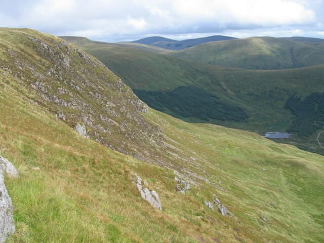
Moorbrock Hill rises east of the Cairnsmore of Carsphairn group, looking down on the Water of Ken and across to Windy Standard's wind turbines. A patch of bare peaty ground marks the highest spot on a long heathery whaleback.
Quick facts
- Height
- 651.4m/ 2137ft
- Prominence
- 113 m
- Distance
- 13 km
- Ascent
- 534 m
- Time
- 3–6 hrs
- Grid ref
- NX620983
- Parking
- NX614992
- Nearest city
- Dumfries· 42km
- Dogs
- Dogs on lead required near livestockDog-friendly guide ↗
Height and prominence cross-checked against the Database of British and Irish Hills (CC BY).
No GPX track yet
Walked this route? Share your track to help other walkers.
Standard route
heather moorland 60% · grass moorland 30% · rocky summit 10%
From the Carsphairn road, take the Brockloch track east and follow open heather onto the ridge. About 13km return with 520m of climb. About 13 km, 534 m of ascent, allow 3.5 hours.
Terrain
Long approach through deep heather and broken peat. The ridge itself firms up into close-cropped grass.
In winter
Wind drives snow off the windward face and piles it deep against the boundary wall on the south flank. SAIS Southern Uplands occasionally flags drift slab here.
Best time of year
Getting there
- Glasgow2h 36m
- Edinburgh2h 6m
OS maps: OS Landranger 77
Mobile signal: Mixed. EE sporadic up top; coverage limited in central Galloway.
Current conditions
Daylight Today
- Sunrise
- 04:59
- Sunset
- 21:47
- Civil dawn
- 04:06
- Civil dusk
- 22:40
NOAA Solar Calculator · 17 July 2026
Around Moorbrock Hill on the SCOT network
Getting there, basing yourself, and what to do off the hill.
Moorbrock Hill — common questions
- How difficult is Moorbrock Hill?
- Moorbrock Hill carries a 3/5 (moderately challenging) grade on the OutdoorSCOT scale. Count on about 13km, 534m of ascent and a 3-6 hour day on the standard route. Underfoot: Long approach through deep heather and broken peat.
- What is Moorbrock Hill's prominence?
- 113m of prominence. That's the vertical drop from the summit to the col that links Moorbrock Hill to the next higher ground.
- Where do I park for Moorbrock Hill?
- Most walkers start from NX614992. Verify the grid reference on an OS map before you set off — space is tight on busy summer weekends.
- When is the best time to climb Moorbrock Hill?
- March, April, May, June, July, August, September, October, November give the most reliable conditions on Moorbrock Hill. Beyond that window the high ground turns wintry: carry full mountain kit, be confident navigating, and check the SAIS avalanche forecast for the area.
- Is Moorbrock Hill dog-friendly?
- Yes, but dogs must be kept on a lead — there is livestock or ground-nesting bird interest on the route.
- Is there mobile signal on Moorbrock Hill?
- Mixed. EE sporadic up top; coverage limited in central Galloway.
- Is Moorbrock Hill safe in winter?
- Wind drives snow off the windward face and piles it deep against the boundary wall on the south flank. SAIS Southern Uplands occasionally flags drift slab here.
Get the OutdoorSCOT weekly
One email a week — new route, hill and bothy guides, seasonal conditions and the odd hard-won lesson. No spam, unsubscribe in one click.