Donald · Southern Uplands
Cairnsmore of Carsphairn
Big rounded Galloway hill that dominates the village of Carsphairn above the A713. The view across to the Galloway Forest Park is exceptional on a clear day, and the upland sheep ground gives easy walking despite the height.
Quick facts
- Height
- 797m/ 2615ft
- Prominence
- 582 m
- Distance
- ~12 km
- Ascent
- ~620 m
- Time
- 3–5 hrs
- Grid ref
- NX594980
- Parking
- NX573940
- Nearest
- Castle Douglas· Dumfries 44km
- Dogs
- Dogs on lead required near livestockDog-friendly guide ↗
Height and prominence cross-checked against the Database of British and Irish Hills (CC BY).
No GPX track yet
Walked this route? Share your track to help other walkers.
Standard route
heather moorland 60% · grass slopes 25% · rocky summit 15%
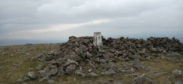
Standard route from Green Well of Scotland car park, then by the wall line between Willieanna and Dunool onto the south-west ridge. A clear estate track runs much of the way before the final pathless pull onto the wide cairned summit.
Terrain
Path through open hillside. Some bog. Pathless near the summit.
In winter
Gentle terrain by Highland standards but cold winds and limited shelter.
Kit for this: the winter Munro kit list · which boots take crampons
Best time of year
Getting there
- Glasgow2h 55m
- Edinburgh2h 25m
OS maps: OS Explorer 328
Mobile signal: Strong summit reception; EE behaves well. Prominent northern Galloway viewpoint.
Current conditions
Daylight Today
- Sunrise
- 07:44
- Sunset
- 18:22
- Civil dawn
- 07:07
- Civil dusk
- 18:59
NOAA Solar Calculator · 14 October 2026
Pair with
Curated multi-hill combinations from Cairnsmore of Carsphairn.
Around Cairnsmore of Carsphairn on the SCOT network
Getting there, basing yourself, and what to do off the hill.
Cairnsmore of Carsphairn — common questions
- How hard is Cairnsmore of Carsphairn?
- We grade Cairnsmore of Carsphairn at 2/5, which puts it in moderate territory. The usual route is around 12km with 620m of climbing; allow 3-5 hours. Terrain: Path through open hillside.
- How prominent is Cairnsmore of Carsphairn?
- Cairnsmore of Carsphairn has 582m of topographic prominence — the height of its summit above the highest col connecting it to higher ground.
- Where should I park to climb Cairnsmore of Carsphairn?
- Standard parking is at NX573940 near Castle Douglas. Check the parking grid reference on an OS map before travel; informal laybys can fill on summer weekends.
- When should I climb Cairnsmore of Carsphairn?
- The standard good-weather months for Cairnsmore of Carsphairn are April, May, June, July, August, September, October. Outside those months, expect winter conditions on the high ground — full mountain kit, navigation skills, and a check of the SAIS avalanche forecast for the relevant region.
- Can I bring my dog up Cairnsmore of Carsphairn?
- On a lead only — the route crosses ground with livestock or nesting-bird interest.
- What's mobile reception like on Cairnsmore of Carsphairn?
- Strong summit reception; EE behaves well. Prominent northern Galloway viewpoint.
- Is Cairnsmore of Carsphairn safe in winter?
- Gentle terrain by Highland standards but cold winds and limited shelter.
Get the OutdoorSCOT weekly
One email a week — new route, hill and bothy guides, seasonal conditions and the odd hard-won lesson. No spam, unsubscribe in one click.